- Lake Cerrillos
-
Lago Cerrillos 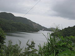
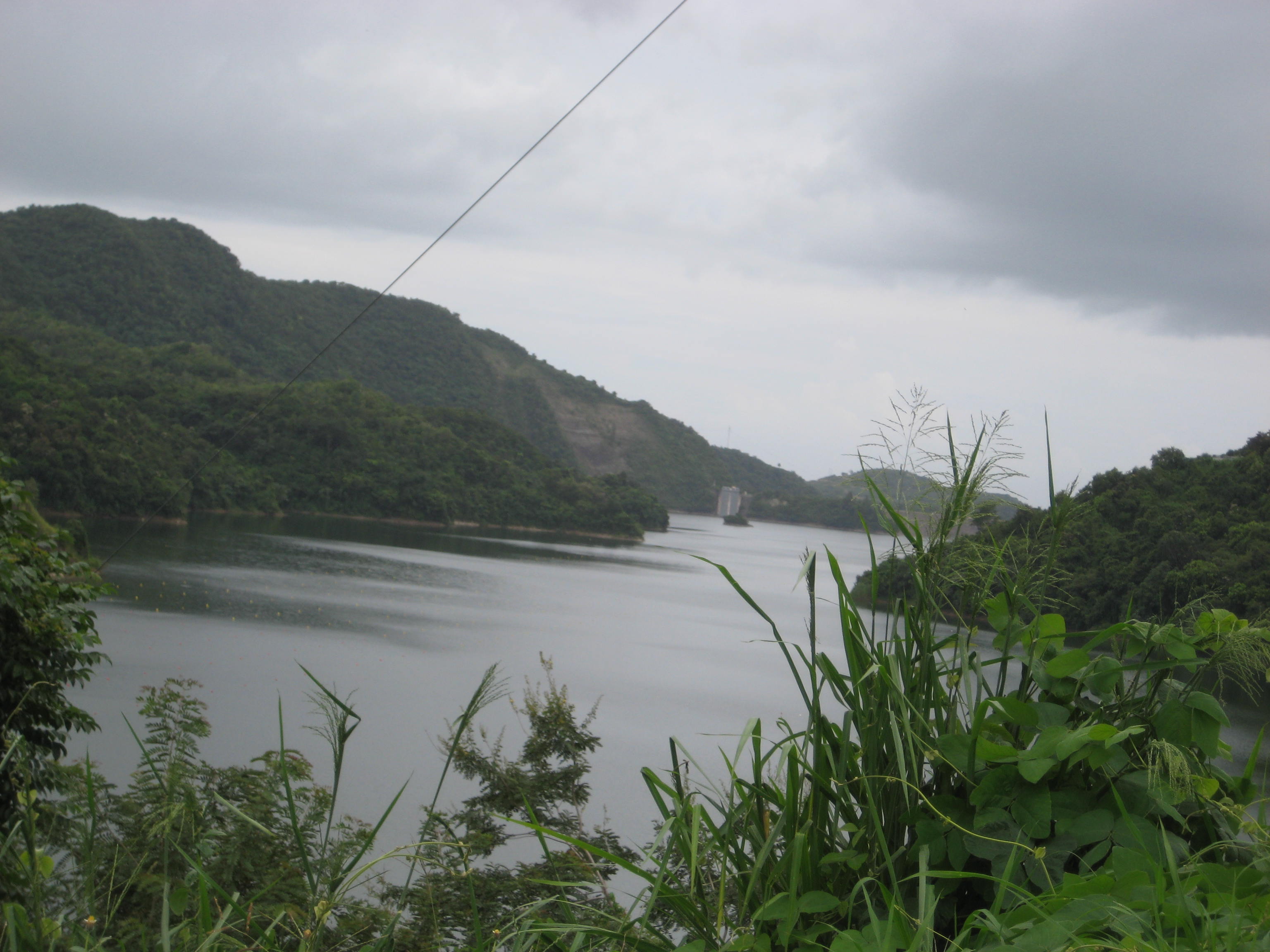
Lake Cerrillos facing south, in the distance Cerrillos Dam Location Barrio Maraguez, Ponce Coordinates 18°34′44.19″N 66°34′44.19″W / 18.5789417°N 66.5789417°WCoordinates: 18°34′44.19″N 66°34′44.19″W / 18.5789417°N 66.5789417°W Lake type artificial reservoir Basin countries Puerto Rico Water volume 47,900 acre feet (59,100,000 m3) Settlements Ponce Lake Cerrillos (Spanish: Lago Cerrillos) is a man-made lake located in barrio Maraguez, Ponce, Puerto Rico.[1] The lake was finished in 1992 by the U.S. Army Corps of Engineers.[2] The main purposes of the reservoir are flood control, water supply, and recreation. There is a variety of fish available for fishing such as lobinas, tucunares, chopas, barbudos y tilapias.[3] The 1993 Central American and Caribbean Games that were held in Ponce staged the canoeing competitions in this lake.[4] It was used in the 2010 Central American and Caribbean Games for the sports of Canoeing, Rowing.[5]
Contents
Dam
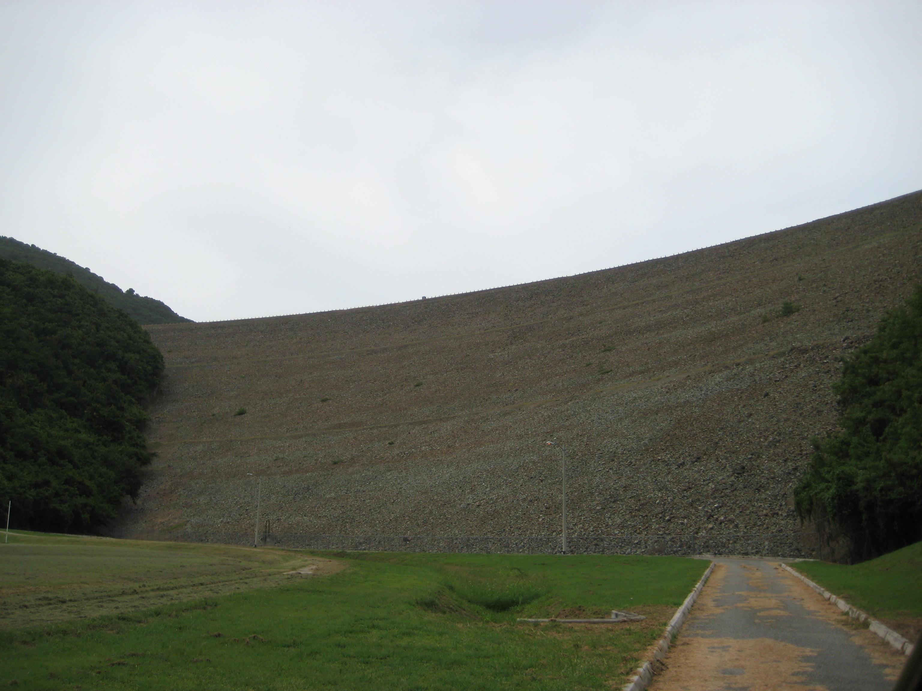
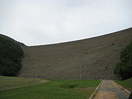 Lake Cerrillos Dam, as viewed from the Luis A. Wito Morales Park
The Lake Cerrillos Dam is located about four miles (6 km) northeast of Ponce. Construction of the dam started in 1984. After its completion in 1992, it still took a few more years for the initial filling of the reservoir.[6] Lake Cerrillos Dam has a total capacity of 59 million cubic meters. In lieu of flood gates, it provides more than 80,000 cubic meters of water daily to the local population through a 434 meters long by 6 meters in diameter tunnel at the dam base.[7]
The dam is 323 feet (98 m) high by 1,555 feet (474 m) wide (Over 1/4 mile).[8] The Dam is located 9.5 miles (15.3 km) from the coast of Ponce, at 323 feet (98 m) above sea level. It provides a volume of 47,900 acre feet (59,100,000 m3) for flood control, as well as an estimated 22,000,000 US gallons per day (83,000 m3/d) of drinking water.[9]
Park
 Cerrillos park
A recreational park was built as part of the development. The park includes two ramps that may be used to launch boats, kayaks, canoes etc. There are also a few nature trails. Open kiosks with barbecue facilities intended for family and friend gatherings are also part of the park.[10] There are five recreational areas: Campo de Recreo, El Atracadero, Bella Mirada, El Mirador, and Alto Balcón. This area was desinated as a state forest under an Executive Order and it consists of more than 200 cuerdas of land.[11]
2010 Central American and Caribbean Games
In 2010 Lake Cerrillos facilities were further improved to accommodate the rowing, canoeing and kayak games of the 2010 Central American and Caribbean Games hosted in the city of Mayaguez. The improvements were made at a cost of $350,000.[12]
See also
- Cerrillos River
References
- ^ Let'sGoToPonce: Insider's Guide to Southern Puerto Rico. Lake Cerrillos. Rerieved November 23, 2009.
- ^ "USGS Lago Cerrillos". USGS. http://pr.water.usgs.gov/public/rt/pr_lakes/lake_50113950.html. Retrieved 2010-05-19.
- ^ "Lago Cerrillos". lobinapr. http://www.lobinapr.com/lobina/lagos/lagos_photos/cerrillo/cerrillo.htm. Retrieved 2010-05-19.
- ^ Lake Cerrillos Dam. Travel-Ponce.
- ^ "Lago Cerrillos". Mayagüez 2010. http://www.mayaguez2010.com/es/instalaciones/deportivas/294-lago-cerrillos.html. Retrieved 2010-05-19.
- ^ Lake Cerrillos Dam. Travel-Ponce.
- ^ Lake Cerrillos Dam. Travel-Ponce.
- ^ Website of the Municipality of Ponce. By Visit Ponce. Descubrelo > Recursos Naturales.
- ^ Government of Puerto Rico. Departmento de Recursos Naturales y Ambientales. Press Release. DRNA inaugura facilidades para competencias de los XXI Juegos Centroamericanos y del Caribe. January 2010.
- ^ Lake Cerrillos Dam. Travel-Ponce.
- ^ Government of Puerto Rico. Departmento de Recursos Naturales y Ambientales. Press Release. DRNA inaugura facilidades para competencias de los XXI Juegos Centroamericanos y del Caribe. January 2010.
- ^ Government of Puerto Rico. Departmento de Recursos Naturales y Ambientales. Press Release. DRNA inaugura facilidades para competencias de los XXI Juegos Centroamericanos y del Caribe. January 2010.
Venues of the 2010 Central American and Caribbean Games in Mayagüez, Puerto Rico Venues in Mayagüez Estadio Centro Americano de Mayagüez · RUM Natatorium · Palacio de Recreación y Deportes · Isidoro García Stadium · El Mani Pavilion · Coliseo Rafael A. Mangual · RUM Racquetball Courts · Santiago Llorens Stadium · RUM Tennis CourtsVenues in Porta del Sol Raymond Dalmau Coliseum · Arquelio Torres Coliseum · Miura Brothers Stadium · Canena Marquez Stadium · Relin Sosa Athletic Track · Aguada Stadium · Hormigueros Gymnastics Pavilion · Aguada Coliseum · Wilfredo Toro Field · Dr. Juan Sanchez Acevedo Coliseum · Julio Rivera Lopez Stadium · Buga Abreu Coliseum · Balneario de Rincón · Archery Facilities Altos de Samán · Balneario de Boqueron · Cabo Rojo Beach Volleyball Courts · Coliseo Rebekah ColbergVenues elsewhere in Puerto Rico Bolera Caribe · Lake Cerrillos · La Sebastina · Yldefonso Sola Morales Stadium · Guayama Convention Center · Albergue OlímpicoVenues outside Puerto Rico Categories:- Lakes of Puerto Rico
- Ponce, Puerto Rico
- 2010 Central American and Caribbean Games venues

Wikimedia Foundation. 2010.