- Condorrat
-
Coordinates: 55°56′18″N 4°01′30″W / 55.93833°N 4.025°W
Condorrat
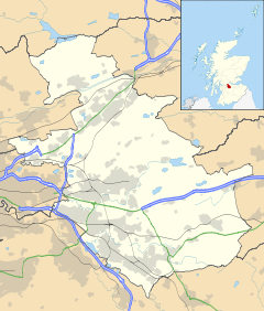
 Condorrat shown within North Lanarkshire
Population (2001 census) OS grid reference NS7373 Council area North Lanarkshire Lieutenancy area Lanarkshire Country Scotland Sovereign state United Kingdom Post town GLASGOW Postcode district G67 Dialling code 01236 Police Strathclyde Fire Strathclyde Ambulance Scottish EU Parliament Scotland UK Parliament Cumbernauld, Kilsyth and Kirkintilloch East Scottish Parliament Cumbernauld and Kilsyth List of places: UK • Scotland • Condorrat is a village on the eastern edges of Dunbartonshire in Scotland. The village origins dates to around the 17th century. Over the past few decades it has been subsumed by the new town of Cumbernauld.
Up until 1975 Condorrat sat within Cumbernauld Burgh and Dunbartonshire County. Upon local government re-organisation in 1975 it found itself part of Cumbernauld & Kilsyth District Council and Strathclyde Regional Council. Finally, in 1995, it was placed within the boundaries of the newly created North Lanarkshire Council.
The area's name coming from the Gaelic "Comh Dobhair Alt", which means the joint river place (the river Luggie meets the Moss Water in the area).[citation needed]
A Dalshannon Farm was located in the area, and it now gives its name to another part of Cumbernauld, Dalshannon, to the West of Condorrat.
Condorrat is the birthplace of the 19th century nationalist figure John Baird, a leading participant in the Radical War of 1820. A plaque is mounted outside the house in which he was born (Airdrie Road).
Condorrat was a weaving community and some of the early single storey houses still exist in the row known as Braehead Cottages - now much modernised. At the west end of the village is Dalshannon Farm which is a very good example of a long house of the 17th century. The longhouse has since been raised in height and a 2 storey block added to the NW corner.
Coordinates: 55°56′06″N 4°01′16″W / 55.935°N 4.02111°W
Categories:- Cumbernauld
- Villages in North Lanarkshire
- West of Scotland geography stubs
Wikimedia Foundation. 2010.

