- Coolmine
-
 Coolmine Station - geograph.ie - 573777.jpg
Coolmine (Cúl Mhín in Irish) is a residential area in West Dublin, Ireland.
Contents
Location and access
Coolmine is located between the suburban centres of Blanchardstown and Clonsilla, in the Dublin 15 postcode. It is roughly 15 kilometres from Dublin city centre. It is a townland in the civil parish of Castleknock which is in turn part of the Barony of Castleknock. The barony (an old administrative division) is one of seven and a half comprising County Dublin and stretches from Cabra to Blanchardstown (from east to west) and from Finglas to Chapelizod (from north to south)[1].
Transport
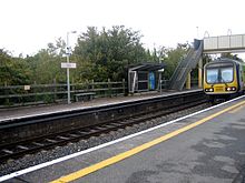
Public transport in Coolmine is provided by Dublin Bus, Urbus and a commuter train station on the Western Suburban Maynooth line. Coolmine railway station was opened on 2 July 1990.[2] The Dublin Bus routes are: 37 38/A/B/C. The privately owned URBus serves Swords via Dublin Airport and may be accessed at nearby Castleknock railway station..
The Navan Road / N3 is the main road artery. The interchange presently under construction will provide for auxiliary lanes between the M1 and N3 junction. The NRA anticipates completion in Q4 2010.[3]
Sport
Coolmine Sports Complex has been the main swimming and gymnastic facility since 1975. It has recently opened floodlit astroturf football pitches. Currently these are the only such facilities available in the area. Coolmine Swimming Club is located here as are Coolmine Karate Club, Taekwondo, Judo, Jujitsu and Coolmine Gymnastics Club.
See also
External links
- Coolmine Community School
- Coolmine Rugby Football Club
- Coolmine Drama Circle
- Coolmine Celtic Football Club
- Blanchardstown Shopping Centre
- Coolmine SC
References
- ^ Note - Townlands in the Barony of Castleknock: Baile an Aba/Abbotstown, Baile an Ásaigh/Ashtown, Baile an Chairpintéaraigh/Carpenterstown, Baile an Déanaigh/Deanestown, Baile an Diosualaigh/Diswellstown, Baile an Huntaigh/Huntstown, Baile an Phóirtéaraigh/Porterstown, Baile Bhlainséir/Blanchardstown, Baile Mhistéil/Mitchelstown, Baile Pheiléid/Pelletstown, Baile Scriobail/Scribblestown, Baile Sheáin/Johnstown, An Chabrach/Cabra(gh), Caisleán Cnucha/Castleknock (incl. part of Phoenix Park), Ceapach/Cappoge or Cappagh, Cnoc na gCaorach/Sheephill, An Chorr Dhubh/Corduff, Dún Sinche/Dunsink, Páirc Anna/Annfield, Snugborough/Snugborough, Steach Gob/Astagob - Placenames Database of Ireland http://www.logainm.ie/Do.aspx?parentID=835&typeID=BF&placeID=17266
- ^ "Coolmine station". Railscot - Irish Railways. http://www.railscot.co.uk/Ireland/Irish_railways.pdf. Retrieved 2007-08-31.
- ^ NRA - N3 / M50 upgrade http://www.nra.ie/RoadSchemeActivity/FingalCountyCouncil/M50UpgradePhase2PPPContract/SchemeName,16458,en.html
Coordinates: 53°23′04″N 6°23′40″W / 53.384489°N 6.394485°W
Categories:- County Dublin geography stubs
- Locations in Dublin (city)
- Articles on towns and villages in Ireland possibly missing Irish place names

Wikimedia Foundation. 2010.