- Tatoi Airport
-
Tatoi Airport
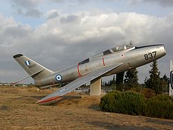
Αεροδρόμιο ΤατοϊουIATA: none – ICAO: LGTT Summary Airport type Public/Military Owner Hellenic Air Force Location Tatoi, Decelea Elevation AMSL 785 ft / 239 m Coordinates 38°06′32.14″N 23°47′01.81″E / 38.1089278°N 23.7838361°E Runways Direction Length Surface ft m 03/21 5,789 1,764 Asphalt Tatoi Airport (ICAO: LGTT) is an airport located north of Athens, in Decelea. It started operating in 1918 and now it has a single runway of 1764m (without counting the 347m. threshold). The airport is used by the Hellenic Air Force and is the base of Dekeleia Aeroclub. It has also been usen used from many other aeroclubs of Attica. Moreover, Hellenic's Air Force museum is situated at the airport with many old and vintage aircraft.
Accidents and incidents
On 27 December 1991, Hellenic Air Force Douglas C-47B KK171 was damaged beyond repair in an accident at Tatoi Air Base. One of the six crew was killed.[1]
References
- ^ "KK171 Accident description". Aviation Safety Network. http://aviation-safety.net/database/record.php?id=1991227-1. Retrieved 24 June 2010.
External links
- LGTT World Aero Data:LGTT
- Dekeleia Aeroclub website
- Airliners.gr Tatoi
 Media related to Dekelia Air Base at Wikimedia Commons
Categories:- Airports in Greece
- Hellenic Air Force bases
- Attica
- European airport stubs
- Greece geography stubs
Wikimedia Foundation. 2010.

