- Dines Green
-
Coordinates: 52°11′33″N 2°15′15″W / 52.192403°N 2.254086°W
Dines Green 
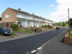
Brookside Road
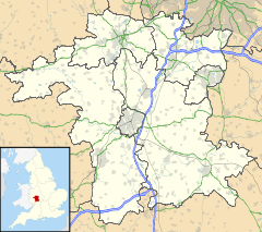
 Dines Green shown within Worcestershire
Population 3,002 [1] OS grid reference SO826551 - London 104 miles (167 km)[2] District Worcester Shire county Worcestershire Region West Midlands Country England Sovereign state United Kingdom Post town WORCESTER Postcode district WR2 Dialling code 01905 Police West Mercia Fire Hereford and Worcester Ambulance West Midlands EU Parliament West Midlands List of places: UK • England • Worcestershire Dines Green is a suburb of Worcester in England, and lies in the St John ward in the west of the city .[3] Initially developed as council housing, the estate now consists of a mix of council and privately owned homes: 49% of households were renting from the council or another landlord as of the 2001 Census.[1]
Contents
History
Formerly farming land, Dines Green was built in the late 1950s by the building contractor Spicers[4] and consisted of a mix of semi-detached homes and large blocks of flats. Worcester City Council at the time wanted uniformity in the front gardens of houses on the estate, turfing over any deviations from this uniformity.[5] The vast majority of the semi detached homes were built using precast concrete; these homes were updated in the 1980s with the concrete being stripped away and replaced with brick. The blocks of flats that were built using pre cast concrete were demolished (also in the 1980s) and new “apartments” built in their place.
The original residents of Dines Green were working class families at the lower end of the social scale. Employment amongst the residents was high though and centred upon mostly unskilled positions and qualified tradesman. The 2001 census found little change: 42% of adults had no qualifications, but unemployment was close to the city average.[1]
When Dines Green was built a small play area for children was provided, but it was lost together with other small grassed areas during the 1980s restoration of the estate.
2007 Worcestershire Flooding
Further information: 2007 United Kingdom floodsDuring the widespread flooding throughout 2007 in Worcestershire, the Dines Green area was hit by water running off the nearby fields and flooding peoples homes.[6] As a result of the flooding, many of the telephone cables in the area were affected, resulting in residents receiving the wrong calls.[7] Flooding was also reported in the area in June 1955.[8]
Amenities
There are a number of shops in Dines Green including a post office. The local church, St Michaels Anglican Church[9] was constructed with much of the estate surrounding it in the early 1960s.[10]
Education
Dines Green Primary School is located on the estate, catering for 169 pupils.[11] Every year the school holds a traditional May Day parade.[12] Following ofsted reports, the school was placed in special measures in 1997 and 2002, however the school was later reassessed in 2006 as being good.[13]
Transport
First have traditionally operated the majority of bus services in Worcester, including the Dines Green estate. Red Diamond are due to start operations in competition with First from 1 September 2009, including a new night bus service on the estate.[14] First used to operate a night service to Dines Green in 2002.[15]
Number From To Via Operator Notes 30 Dines Green Worcester First
Red Diamond (from 1 September 2009)[16][17]
[18]N30 Dines Green Worcester Red Diamond (from 1 September 2009) Night bus.[19] See also: List of bus routes in WorcestershireExpansion
As part of the South Worcestershire Joint Core Strategy plan, Dines Green has been earmarked to receive 3,500 extra homes. The construction will include primary and secondary schools, alongside extra shops and leisure facilities.[20] A £100 million northern link road was planned to link the area to Barbourne, however in 2008 this plan was cancelled due to fears of increased commuting.[21]
Sport
Nathan Baker is a professional footballer who was born in Dines Green. He is currently playing at Premier League side Aston Villa, but has also played on loan at Lincoln City in Coca-Cola League Two.
References
- ^ a b c 2001 Census Profile - Dines Green. Worcestershire County Council Research and Intelligence Unit.
- ^ "Gazetteer (how far)". GENUKI. http://www.genuki.org.uk/cgi-bin/howfar?FROMGR=SO826551. Retrieved 2009-07-14.
- ^ Office for National Statistics. "Information on: St John (Ward)". Neighbourhood.statistics.gov.uk. http://www.neighbourhood.statistics.gov.uk/dissemination/LeadAreaMetadata.do;jsessionid=ac1f930d30d686b8ce394f5a4ca3b1dfb5f278a98c98?a=3&b=6102128&c=St+John&d=14&g=499850&i=1001x1003&m=0&r=1&s=1247582418484&enc=1&areaId=6102128&nsjs=true&nsck=true&nssvg=false&nswid=1491. Retrieved 2009-07-14.
- ^ The City of Worcester. Littlebury. 1953. p. 217. http://books.google.com/books?lr=&ei=UnxcSpmoCJHAzgSRmpmWBw&id=jMc0AAAAIAAJ&dq=%22Dines+Green%22&q=Spicers#search_anchor. Retrieved 14 July 2009.
- ^ Lejeune, Anthony (1956). Anthology. A. Deutsch. p. 82. http://books.google.co.uk/books?ei=d4xcSqXXBqnWzATIrJwT&id=Wy1KAAAAMAAJ&q=Worcester+City+Council. Retrieved 14 July 2009.
- ^ "FLOODS: Dines Green homes latest to be hit by flash flooding (From Bromsgrove Advertiser)". Bromsgroveadvertiser.co.uk. 2007-07-20. http://www.bromsgroveadvertiser.co.uk/search/1562180.FLOODS__Dines_Green_homes_latest_to_be_hit_by_flash_flooding/. Retrieved 2009-07-14.
- ^ "More homes affected by phones chaos (From Worcester News)". Worcesternews.co.uk. 2007-08-03. http://www.worcesternews.co.uk/news/1595102.more_homes_affected_by_phones_chaos/. Retrieved 2009-07-14.
- ^ "Go-ahead finally given for Earls Court homes (From Hereford Times)". Herefordtimes.com. 2007-12-01. http://www.herefordtimes.com/news/1873647.goahead_finally_given_for_earls_court_homes/. Retrieved 2009-07-14.
- ^ "St Michaels, Dines Green Worcester". Eden.co.uk. http://www.eden.co.uk/churches/worcester/st_michaels__dines_green_9176.html. Retrieved 2009-07-14.
- ^ "Our Project". Cofe-rushwick-dinesgreen.org.uk. http://cofe-rushwick-dinesgreen.org.uk/our_project_12.html. Retrieved 2009-07-14.
- ^ "Worcester, Dines Green Primary School". Ofsted. http://www.ofsted.gov.uk/oxedu_providers/full/(urn)/116751. Retrieved 2009-07-14.
- ^ "Children enjoy May Day parade (From Worcester News)". Worcesternews.co.uk. 2009-05-02. http://www.worcesternews.co.uk/news/local/4337398.Children_enjoy_May_Day_parade/. Retrieved 2009-07-14.
- ^ "COMMENT: Well done to all at Dines Green School (From Bromsgrove Advertiser)". Bromsgroveadvertiser.co.uk. 2009-06-01. http://www.bromsgroveadvertiser.co.uk/search/4406467.COMMENT__Well_done_to_all_at_Dines_Green_School/. Retrieved 2009-07-14.
- ^ "Rotala's Diamond Bus and First to go head-to-head in Worcester | TXNews". TransportXtra. 2009-08-06. http://www.transportxtra.com/magazines/new_transit/news/?ID=17157. Retrieved 2009-08-16.
- ^ mikewal1947. "First Midland Red Bus Service News". http://myweb.tiscali.co.uk/worcesterfolk/FMRArchive.htm. Retrieved 2009-08-16.
- ^ First service 30 timetable (before 1 September 2009)
- ^ First service 30 timetable (from 1 September 2009)
- ^ Diamond service 30/N30 timetable (from 1 September 2009)
- ^ Diamond service 30/N30 timetable (from 1 September 2009)
- ^ "EXCLUSIVE: Plans for two decades of change in city (From Worcester News)". Worcesternews.co.uk. 2008-06-07. http://www.worcesternews.co.uk/news/2325964.exclusive_plans_for_two_decades_of_change_in_city/. Retrieved 2009-07-14.
- ^ "Northern link road would be negative for the city (From Worcester News)". Worcesternews.co.uk. 2008-06-21. http://www.worcesternews.co.uk/news/3173650.Northern_link_road_would_be_negative_for_the_city/. Retrieved 2009-07-14.
External links
Categories:- Geography of Worcester
Wikimedia Foundation. 2010.

