Corrachadh Mòr

Corrachadh Mòr
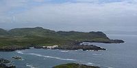
Corrachadh Mòr to the right and Mull in the distance as seen from the Ardnamurchan Point lighthouse

Corrachadh Mòr ETRS89 (56°42′56.20328″N 6°13′40.59731″W / 56.7156120222°N 6.2279436972°W / 56.7156120222; -6.2279436972; grid reference NM414662) is a small hillock on the Ardnamurchan peninsula in Lochaber, Highland, Scotland, notable for adjoining the most westerly point on the island of Great Britain. It is about 36 kilometres (22 mi) further west than Land's End in Cornwall.

Depending on which coordinates are used, this headland is 30.78 metres or 42.81 metres west of Ardnamurchan Point (about a kilometre to the north). The latter is commonly, but incorrectly, described as being the most westerly point on the peninsula.

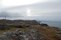
Corrachadh Mòr as seen from the Ardnamurchan Point lighthouse, in a photograph taken at local noon, when the sun lies due south of the location. Using this as a datum, the westerly extension of Corrachadh Mòr with respect to Ardnamurchan Point is clearly seen.

Corrachadh Mòr means 'great, tapering field' in the Scottish Gaelic.

See also


Wikimedia Foundation. 2010.

Игры ⚽ Нужно сделать НИР?

Look at other dictionaries:

  • Corrachadh Mor — Blick auf Corrachadh Mòr (rechts) vom Ardnamurchan Leuchtturm aus, im Hintergrund die Insel Mull. Corrachadh Mòr ist ein kleiner Hügel am Ende einer Landzunge auf der Halbinsel Ardnamurchan, Schottland. Er liegt etwas südlich des Point of… …   Deutsch Wikipedia

  • Corrachadh Mòr — Blick auf Corrachadh Mòr (rechts) vom Ardnamurchan Leuchtturm aus, im Hintergrund die Insel Mull. Corrachadh Mòr ist ein kleiner Hügel am Ende einer Landzunge auf der Halbinsel Ardnamurchan, Schottland. Er liegt etwas südlich des Point of… …   Deutsch Wikipedia

  • Extreme points of the United Kingdom — This is a list of the extreme points of the United Kingdom: the points that are farther north, south, east or west than any other location. Traditionally the extent of the island of Great Britain has stretched from Land s End to John o Groats… …   Wikipedia

  • Rubha Aird nam Murchan — Point of Ardnamurchan Der Point of Ardnamurchan (schottisch gälisch: Rubha Aird nam Murchan) auf der Halbinsel Ardnamurchan liegt in der Nähe des westlichsten Punktes der Insel Großbritannien auf rund 6° 14′ westlicher Länge. Somit liegt er… …   Deutsch Wikipedia

  • Taigh Solais Aird nam Murchan — Ardnamurchan Leuchtturm Taigh Solais Aird nam Murchan Leuchtturm Ardnamurchan Ort: Halbinsel Ardnamurchan …   Deutsch Wikipedia

  • Geographie de l'Ecosse — Géographie de l Écosse Carte topographique de l Écosse Bien que l Écosse soit un pays relativement petit, avec une superficie de 78 772 km², sa géographie est elle très variée, allant des lowlands ruraux aux highlands désertiques, et des grandes… …   Wikipédia en Français

  • Géographie De L'Écosse — Carte topographique de l Écosse Bien que l Écosse soit un pays relativement petit, avec une superficie de 78 772 km², sa géographie est elle très variée, allant des lowlands ruraux aux highlands désertiques, et des grandes villes aux îles… …   Wikipédia en Français

  • Géographie de l'Écosse — Carte topographique de l Écosse Bien que l Écosse soit un pays relativement petit, avec une superficie de 78 772 km², sa géographie est elle très variée, allant des lowlands ruraux aux highlands désertiques, et des grandes villes aux îles… …   Wikipédia en Français

  • Géographie de l'écosse — Carte topographique de l Écosse Bien que l Écosse soit un pays relativement petit, avec une superficie de 78 772 km², sa géographie est elle très variée, allant des lowlands ruraux aux highlands désertiques, et des grandes villes aux îles… …   Wikipédia en Français

  • Geografía de Escocia — Mapa de Escocia. Aunque Escocia sea un país relativamente pequeño, ya que ocupa una superficie de 78.772 km², posee una geografía sumamente variada, que abarca desde las lowlands rurales a las highlands desértica, o de las grandes ciudades a las… …   Wikipedia Español

Share the article and excerpts

Direct link
Do a right-click on the link above
and select “Copy Link”