Day River

Day River
Hát Giang, sông Gián Khẩu
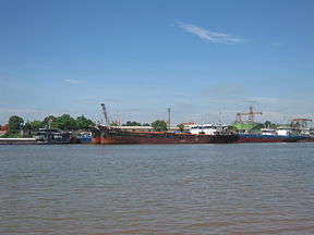
250px
Day River through Ninh Phúc Port
Origin Đan Phượng
Mouth Đáy Mouth, Kim Sơn
Basin countries Vietnam
Location Hà Nội, Hòa Bình, Hà Nam, Ninh Bình and Nam Định
Length 240 km (150 mi)
Mouth elevation 0

The Day River (Vietnamese: Sông Đáy) is a river in Vietnam. It was formerly known as Sông Hát or Hát Giang. The river is a distributary of the Red River, draining into the Gulf of Tonkin.

The river has a length of 240 km[1] and has a drainage basin of more than 7,500 km²[2], flowing through Hanoi, and the provinces of Hòa Bình, Hà Nam, Ninh Bình and Nam Định.

References

  1. ^ http://www.rfa.org/vietnamese/in_depth/2007/04/28/VnpressReview_NNguyen/
  2. ^ http://www.nea.gov.vn/Sukien_Noibat/Luuvuc_Song/tintuc.htm


Wikimedia Foundation. 2010.

Игры ⚽ Нужно решить контрольную?

Look at other dictionaries:

  • John Day River — Geobox River name = John Day River native name = other name = other name1 = image size = image caption = country = United States country1 = state = Oregon state1 = region = region1 = district = district1 = city = city1 = length imperial = 281… …   Wikipedia

  • North Fork John Day River — Coordinates: 44°45′22″N 119°38′19″W / 44.75611°N 119.63861°W / 44.75611; 119.63861 …   Wikipedia

  • South Fork John Day River — Geobox | River name = South Fork John Day River category = River image size = image caption = South Fork John Day River at Dayville etymology = John Day, fur trapper country = United States country state = Oregon district type = County district …   Wikipedia

  • Middle Fork John Day River — Coordinates: 44°54′59″N 119°18′08″W / 44.91639°N 119.30222°W / 44.91639; 119.30222 …   Wikipedia

  • John Day River (northwestern Oregon) — The John Day River is a tributary of the Columbia River, approximately 15 mi (24 km) long, in northwestern Oregon in the United States. The river is one of two tributaries of the Columbia in Oregon to bear the name John Day River . The other John …   Wikipedia

  • Bridge Creek (John Day River) — Geobox | River name = Bridge Creek category = Creek image size = image caption = Bridge Creek in the Painted Hills etymology = A small bridge made of juniper logs that mining prospectors built over the creek in about 1862.cite book | last =… …   Wikipedia

  • John Day River — Sp Džòno Dėjaus ùpė Ap John Day River L JAV (Oregonas) …   Pasaulio vietovardžiai. Internetinė duomenų bazė

  • River Thames — Thames redirects here. For other uses, see Thames (disambiguation). Coordinates: 51°29′56″N 0°36′31″E / 51.4989°N 0.6087°E / 5 …   Wikipedia

  • river — river1 riverless, adj. riverlike, adj. /riv euhr/, n. 1. a natural stream of water of fairly large size flowing in a definite course or channel or series of diverging and converging channels. 2. a similar stream of something other than water: a… …   Universalium

  • River FM — Infobox Radio Station name = River FM city = area = West Lothian branding = slogan = airdate = 1 September 2003 frequency = 103.4. MHz, 107.7 MHz format = Contemporary power = erp = class = callsign meaning = owner = Kingdom Radio Group website …   Wikipedia

Share the article and excerpts

Direct link
Do a right-click on the link above
and select “Copy Link”