- Bicol River
Geobox River
name = Bicol River
native_name =
other_name =
other_name1 =
other_name2 =
image_size =
image_caption =
country = flagicon|PhilippinesPhilippines
region =Bicol Region
district =
district1 =
city =Naga City
city1 =Iriga City
length = 94
length_round = 2
watershed = 3770
watershed_round = 2
discharge_location =San Miguel Bay
discharge = 165
discharge_round =2
discharge_max = 205
discharge_max_round = 2
discharge_min = 123
discharge1_location =
discharge1 =
source_name =Lake Bato
source_location =Albay
source_district =
source_region =Bicol Region
source_lat_d = 13
source_lat_m = 19
source_lat_s = 55
source_lat_NS = N
source_long_d = 123
source_long_m = 21
source_long_s = 32
source_long_EW = E
source_elevation = 6
source_length =
mouth_name = Mouth of the Bicol River
mouth_location = Between Cabusao and Calabanga,Camarines Sur
mouth_district =
mouth_region =Bicol Region
mouth_lat_d = 13
mouth_lat_m = 43
mouth_lat_s = 00
mouth_lat_NS = N
mouth_long_d = 123
mouth_long_m = 06
mouth_long_s = 25
mouth_long_EW =E
mouth_elevation = 0
tributary_left = Libmanan River
tributary_left1 = Sipocot River
tributary_right =
tributary_right1 =
free_name =
free_value =
map_size =
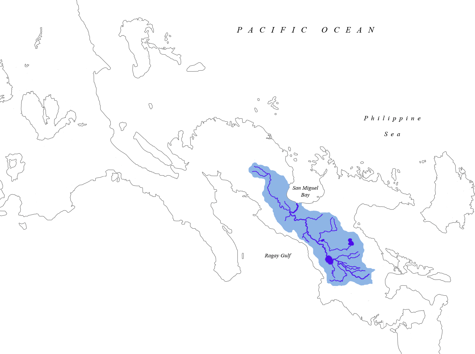
map_caption =Drainage area of Bicol RiverBicol River is the eight largest river in thePhilippines in terms ofwatershed size with an estimated catchment area of 3, 770 km². The river drains the southwestern part of the island of Luzon and passes throughCamarines Sur ,Albay , andCamarines Norte provinces in theBicol Region cite web|url=http://www.rdc5.gov.ph/rdcprograms/rbmpmain.htm|title=Bicol River Basin and Water Management Project|publisher=Regional Development Council - Bicol Region|language=English|accessdate=2008-09-12] .The river starts from
Lake Bato , 6 meters above sea level, and flows 94 kilometers downstream to itsestuarine mouth atSan Miguel Bay . It passes through the alluvial and coastal plains of the vast Bicol Valley, an elongated, northwesterly trending depression in the Bicol Region, which contains alluvial plains to the coastal plain. Average slope within the river's watershed is 0.006%.The basin has an influence area of 10,058 square kilometers including its
watershed . It lies between 13°0 to 14°N and 123°0 and 124°0 E. It is extensively a coastal flood plain.Geography
Geology and Geomorphology
The Bicol River is bounded on the northeast by the
Bicol Cordillera , which consists of a chain of volcanic mountains includingMount Iriga ,Mount Malinao ,Mount Masaraga andMount Mayon . On the southwestern side lie theRagay Hills , which consists of folded and faulted sedimentary formations includinglimestones ,siltstones ,conglomerates andshale . In between these higher areas lies the Bicol plain, which is composed of thickalluvial deposits ofsand silt andclay cite web|url=http://www.itc.nl/library/Papers_2004/msc/ereg/otieno.pdf|title=Scenario Study for Flood Hazard Assessment in the Lower Bicol Floodplain: The Philippines Using a 2D Flood Model|last=Otieno|first=Jennifer A.|date=2004|publisher=International Insitute for Geo-Information Science and Earth Observation|pages=pp 3-10|language=English|accessdate=2008-09-12] .The main geo-morphological features found in the are include the estuarine plain, a river flood plain, the piedmont plain and the valleys of incised creeks. The estuarine plain is level to nearly level and consists of fine fluvial-marine deposits over sandy layers with marine shells. The fluvial marine deposits are usually saline at depths of approximately 1 meter and includes depresses areas along the Bicol River. The river floodplain is made up of mixed alluvium. The piedmont plain on the fringe of the
Ragay Hills consists of fine alluvium clay and reworked colluviums.Climate
The climate is influenced by the Northeast Monsoon winds and the Pacific trade winds. These
Monsoon winds create thelow pressure area in the Pacific Ocean, resulting intropical cyclones that affect the area in November and December.Rainfall occurs throughout the year with low rainfall between January to May and high rainfall between June and December. In the lower basin, mean annual rainfall ranges between 1,850-2,300 mm. The main factors influencing rainfall are the air streams, the inter-tropical convergence zone and topography.The mean temperatures are high throughout the year with the daily mean temperatures in the range of 24.1°C to 28.1°C and an annual mean temperature of 27°C.
References
Wikimedia Foundation. 2010.