- Başkale
Infobox Settlement
settlement_type = District
subdivision_type = Country
subdivision_name = TUR
timezone=EET
utc_offset=+2
map_caption =Location of Başkale within Turkey.
timezone_DST=EEST
utc_offset_DST=+3official_name = Başkale
image_caption =
image_blank_emblem =
blank_emblem_type =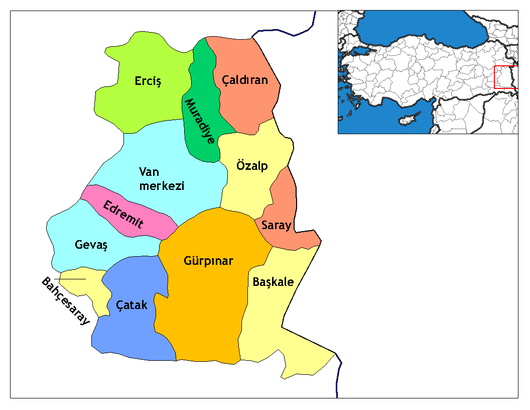
subdivision_type1=Region
subdivision_name1 = East Anatolia
subdivision_type2=Province
subdivision_name2 = Van| population_total = 55563|population_footnotes=
population_as_of =| 2000
population_footnotes = http://www.baskale.gov.tr
population_density_km2 =
area_total_km2 = 2599|elevation_m = 2460|postal_code_type=Postal code
postal_code = 65x xx
blank_info = 65|blank_name=Licence plate
area_code = (0090)+ 432
leader_title=Mayor
leader_name = Ejder Yağızer Justice and Development Party
website = [http://www.yerelnet.org.tr/baskale www.yerelnet.org.tr/baskale]
leader_title1=Governor
leader_name1 = Ali ARSLANTAŞ
gwebsite = [http://www.baskale.gov.tr www.baskale.gov.tr]Başkale (Kurdish: Elbak, Armenian: Albayrak, and alternatively rendered as Bashkala or Pashgala) is a town and district located in south-eastern
Turkey inVan Province . Başkale was formerly called Elbak and was the capital town of Elbakkaza of Hakkarisanjak in the Ottoman Vilayet of Van. [Kamusü’l Alam] After the constitution of the republic ofTurkey in 1923, its name was changed as "Başkale" and it became a part ofVan Province ."Başkale" means "head fortress" (head meaning "located at the head of the valley") in Turkish.
There is one municipality in the Başkale district, the town centre, which was established 1937. The neighbourhoods of the town of Başkale are:
Tepebaşı ,Yeni mahalle ,Camii-Kebir ,Samandöken ,Cevkan , Kale,Hafiziye ,Tarım andYakınyol .Geography
Başkale is situated convert|20|km|mi|0|abbr=on west of the Turkey-Iran border. convert|138|km|mi|0|abbr=on of the national border is on the east and north-east of the Başkale district. Başkale shares district borders with
Yüksekova district ofHakkari Province to the south,Saray andÖzalp districts ofVan Province to the north, andGürpınar district ofVan Province to the west.Başkale is situated 2460 metres above sea level, in the valley of the Great Zab River, and the town stands on the eastern slope of the south eastern
Taurus Mountains . The majority of the convert|2599|km2|sqmi|0|abbr=on Başkale district is mountainous. The agricultural portion is only convert|355|km2|sqmi|0|abbr=on, approximately 14% of the total area. Başkale is enclosed by Mount (Yiğit)/Haravil (3468 m) in the east, Mount Başkale/İspiriz (3668 m) in the west, and Mount Gökdağ (3604 m) in the south-east. The mountains of Mor, Haravil, Mengene and Çekvan are in district of Başkale. Other geographical features in Başkale include the the Zapsuyu and Karasu rivers, and the plateaus of Nebirnav, Kevçikan, Hanasor, Çekvan, Aşkitan (Ülya), Perihan, Meydan, Harinan, Terazın, Sülav, Medgezeren, Pistekan, Herevil-Şirez, Derevan, Derik, Bağarük, Düava and Mengen.History
The city of Başkale was first settled by
Parthia ns as a border city in the first century AD. Armenian King Tigranes took control of the area for a short period. Control of the area alternated betweenParthia and theRoman Empire . In the third century theSassanid Empire took control of area from theRoman Empire . After the division of theRoman Empire , theByzantine Empire took control in the sixth century.In 645
Arab s took control of the Başkale area for a short period and control returned to theByzantine Empire via theVaspurakan lords. After theBattle of Malazgirt in 1071, control passed toSeljuk Empire . After 1100,Ahlatshah beylik (Sökmenoğulları) controlled the area. After a short period of Ayyubid control and theMongol attack of 1245, the region was controlled byAnatolian Seljuks , İlhanlılar, andTimur . After the overthrow ofTimur in 1386 by Kara Koyunlu federation of Turkoman tribes, theSafavids took control at the beginning of the sixteenth century. When theYavuz Sultan Selim defeated theSafavids in theBattle of Çaldıran , Van and surrounding area was included inOttoman Empire , but control returned to theSafavids several times after theBattle of Çaldıran . In 1548, during the period of Kanuni Sultan Süleyman, theOttoman Empire finally took full control of the area.One of many events in the string of tensions prior to
World War I was a massacre of approximately fifty GawarnaiAssyrians by Muslims on30 October 1914 at Başkale in the local government centre.Fact|date=June 2007 Armenians of Başkale were later deported and massacred by Turks and Kurds during theArmenian genocide . [cite web|url=http://www.lib.byu.edu/~rdh/wwi/1915/bryce/a04.htm|title=The Treatment of Armenians in the Ottoman Empire: 1915-1916|author=Viscount Bryce|year=1916|publisher=Crown of United Kingdom Refer to section III. Vilayet of Bitlis; General description #21.]City features
Başkale is best known historically for being a military station. Its now ruined fortress was once occupied by a Kurdish
bey (chieftain)Fact|date=June 2007 and lies a short distance uphill from the township. The fortress is a good example of Urartian architecture.Fact|date=June 2007Demography and population
The population of the town of Başkale was 14,114, and of the district was 55,563 (2000 census). Approximately 80% of the district speaks a Kurdish dialect. [cite web|url=http://www.baskale.gov.tr|title=Başkale District Government Office|accessdate=2007-06-12 tr icon] The population structure shows a tribal construction, with the breakdown of ethnic groups given as follows [cite web|url=http://www.baskale.gov.tr|title=Başkale District Government Office|accessdate=2007-06-12 tr icon] :
Health services
There is one hospital and 5 clinics at Başkale district, with a total; 21 doctors and 36 health officers(midwife, nurse, health technician) in charge of health service in district.
*Başkale Hospital; in Başkale town
*Başkale center clinic; in Başkale town
*Albayrak village clinic; is in Albayrak village
*Çaldıran village clinic;is in Çaldıran village
*Eşmepınar village clinic; in Eşmepınar villageEconomy
Stock-breeding is dominant in the economy of Başkale district.Smuggling also is a widespread activity in border areas.There is no industrial activities except small workshops. There was a
Marble production plant at Koçdağı village, but in 2001 was closed after some test production.Distribution of the population according to their economical activity;:*Stock-breeding; 80%:*Agriculture; 10%:*in different crafts; 8%:*trade; 2%Agriculture
tock-breeding
Culture
There is one local radio station Pınar FM in Başkale.
Education
In Başkale district; ratio of educated people to total population is; 65% (November 2006) [http://baskale.meb.gov.tr/ Başkale National Education Directorate] . Due to the demographic and traditional conditions, in the past,; majority of women and girls are not sent to schools. Educated people level among women is dramatically low.
In Başkale district;(November 2006) [http://baskale.meb.gov.tr/ Başkale National Education Directorate] :*total number of teachers ; 402::*Total number of girls in schools; 5,384::*Total number of boys in schools; 7,437::*Total number of students in village schools; 8,424::*Total number of students in town schools; 4,404:*Number of total students; 12,828
port
Başkale has a football team named as "Başkale Spor" in amateur league."Vali Abdülkadir SARI Football Stadium" was opened in 1999 which has 1,500 seats.Başkale has also a gymnasium also finished at 1999.
Cuisine
Otlu peynir (a kind of cheese which include natural vegetables which differs with region) is a well known product of Başkale.Otlu peynir of Başkale includes these local natural vegetables; Devin, Mendi, Spi pancar, Pinger, Çatır, Nane, Handekuk, Spilinge, Kaşım, Kurat, Sirik, Gunbizin, Sılkuke, Sinameki, Mendi, Sirmo.Başkale has many local varieties like as;
Ayranaşı ,Pancarlı Pilav ,Keledoş ,Keşkeş ,Roasted Pancar ,Pokin soup ,Grara aki soup ,Şoğra ,Şeleke ,Vireke ,Tahinik Tourism and places to see
Başkale has two hotels with a total 51 beds. There are many restaurants which serve local dishes.
Historical places
* Albayrak church
* Yanal church
* Erek church
* Örenkale(Başkal) castle
* Örenkale(Başkal) Seljuk medrese and dome
* Başkale castle
* St. Bartholomeus church
* Soradir church
* Castle Mosque
* Hüsrev Paşa MedreseNatural places
*Yavuzlar village fairy chimneys (locally called as "Vanadocia" referring to
Cappadocia
*Çamlık (kolegom) hot springs and picnic area
*Akçalı village limestone and travertine formation like asPamukkale Entombed saints
*Dereiçi village; Adil Kabul
*Köprüağzı village; Hejde Kev
*Esenyamaç village ; Kepenereş and Şah Şıh
*Öncüler village; Kelasinci Hevat
*Yavuzlar village; Mollahıdır Firendi
*Zap basında; Mehmet Çavuş yatırı
*Başkale ; Seyyid İsmail Hokan yatırı
*Güroluk village ; Şah İsmail Kutbeddinin and Şeyh İsmail Hakkari
*Çaldıran village; Şeyh Sucu
*Öncüler village ; Uzun Şehid
*Ilıcak village ; Pir
*Örencik village; Arafat ArabiExternal links
*" [http://www.baskale.gov.tr/ www.baskale.gov.tr District government official web] "
References
Wikimedia Foundation. 2010.