- Guayrá
-
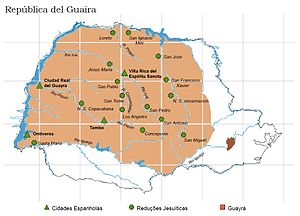
 Map the modern Brazilian state of Paraná showing the Guayrá region in brown, Jesuit misions are marked with crosses and Spaniahs cities with triangles.
Guayrá was a former region of the Spanish Empire in what is now modern Paraguay and Brazil. It was named after a cacique of the region whose name was Guayrá or Guayracá.
The limits of Guayrá were the Iguazu River on the south, the Paraná River on the west, the Tiete (or Añemby) River to the north, and the line of the Treaty of Tordesillas to the east. The Tiete also marked the boundary between the Tupi and Guarani Indians.
Aleixo Garcia crossed the region in 1522. In 1542, Alvar Nunez Cabeza de Vaca travelled through its southern reaches on his way to Asunción from Santa Catarina Island.
The town of Ontiveros was founded by Captain Garcia Rodriguez de Vergara on orders from Domingo Martínez de Irala in 1554. It was located on the left bank of the Paraná, between the Iguazu and Pipiri-Guazu, about 50 kilometers north of Salto del Guairá, in the territory of the cacique Canendiyu, and was intended to serve as a connection to Portuguese Brazil.
Ciudad Real del Guayrá (also referred to simply as Guayrá) was founded by Captain Ruy Diaz Melgarejo, on the left bank of the Parana at the confluence of the Pipiry-Guazu, in 1556.
Guayrá was covered with dense forest and many rivers, and by 1600, it had become a place of refuge for the Guarani from the encomenderos of Paraguay and the esclavistas of Brazil. It was the main region occupied by the Jesuit reductions.
Categories:- Geography of Brazil
- Geography of Paraguay
- Paraguay geography stubs
- Brazil geography stubs
Wikimedia Foundation. 2010.
