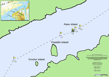
Crozier Island

Crozier Island
Crozier Island

Nares strait border (Kennedy channel)
Geography
Coordinates 80°30′N 67°05′W / 80.5°N 67.083°W / 80.5; -67.083
Highest elevation 60 m (200 ft)
Country

Crozier Island (Danish: Crozier Ø) is one of three islands located in Kennedy Channel of Nares Strait in the high Arctic, and is part of Greenland. Its two sister islands are Franklin Island and Hans Island. The former is also part of Greenland, whilst the latter's ownership is disputed between Greenland and Canada.

It is the southernmost island in Kennedy Channel. It fronts Lafayette Bugt and is reported to be easily identified. The cliffs at its southwest side rise to a height of 60 m (200 ft).

It is named after the Irish-born, British naval officer Francis Rawdon Moira Crozier second-in-command (and commander after Franklin's death) of John Franklin's ill-fated Naval Northwest Passage Expedition, 1845–1848, by Elisha Kent Kane between 1854 and 1855 during his second Grinnell Expedition, after it was sighted by Hans Hendrik and the American William Morton in June 1854.

Coordinates: 80°30′N 67°05′W / 80.5°N 67.083°W / 80.5; -67.083

See also

  • List of islands of Greenland

References


External links


Wikimedia Foundation. 2010.

Игры ⚽ Нужно сделать НИР?

Look at other dictionaries:

  • Crozier Strait — is a natural waterway in Qikiqtaaluk, Nunavut, Canada. It separates Bathurst Island s Gregory Peninsula to the west from Milne Island and Little Cornwallis Island to the east.[1] The strait, an arm of the Arctic Ocean, connects Queens Channel to… …   Wikipedia

  • Crozier Channel — The Crozier Channel (76°0′N 119°0′W / 76°N 119°W / 76; 119Coordinates …   Wikipedia

  • Francis Crozier — Infobox Military Person name= Francis Rawdon Moira Crozier born=September 1796 died=1848 placeofbirth=Banbridge, Kingdom of Ireland placeofdeath= caption= Francis Rawdon Moira Crozier nickname= allegiance= flagicon|United Kingdom United Kingdom… …   Wikipedia

  • Hans Island — Infobox Islands name = Hans Island Hans Ø Île Hans image caption = Map of part of Kennedy Channel, with the disputed Island. image size = locator map custom = native name = Tartupaluk native name link = Inuktitut nickname = location = In the… …   Wikipedia

  • Houston Stewart Island — Infobox Islands name = Houston Stewart Island image caption = image size = locator map custom = native name = native name link = Inuktikut nickname = location = Northern Canada coordinates = coord|75|44|0|N|95|28|0|W|type:isle region:CA… …   Wikipedia

  • Franklin Island — ( da. Franklin Ø) is one of three islands located in Kennedy Channel of Nares Strait in the high Arctic, and is part of Greenland. Its two sister islands are Crozier Island and Hans Island. The former is also part of Greenland, whilst the latter… …   Wikipedia

  • Dauphin Island Sea Lab — Logo The Dauphin Island Sea Lab (DISL) is Alabama s primary marine education and research center. DISL is the home site of the Marine Environmental Sciences Consortium and was founded by an act of the Alabama State Legislature in 1971. It also… …   Wikipedia

  • Francis Crozier — Francis Rawdon Moira Crozier (* 16. August[1] 1796 in Banbridge, County Down, Irland; † Winter 1848 in der Nähe der King William Insel, Kanada) war ein irischstämmiger Offizier der britischen Royal Navy, der an mehreren Expeditionen in Arktis und …   Deutsch Wikipedia

  • Cape Crozier — is the most easterly point of Ross Island in Antarctica, at coord|77|30|S|169|20|E. It was discovered in 1841 during James Clark Ross s expedition with HMS Erebus and HMS Terror , and was named after Francis Crozier, captain of HMS Terror. The… …   Wikipedia

  • Coulman Island — DMS …   Deutsch Wikipedia

Share the article and excerpts

Direct link
Do a right-click on the link above
and select “Copy Link”