- Mount Tammany
-
Mount Tammany 
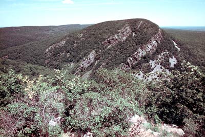
Mount Tammany 's south face, November 2008Elevation 1,527 ft (465 m) Location Location of Mount Tammany in New Jersey
 Mount Tammany
Location Delaware Water Gap, Warren County, New Jersey, USA Range Kittatinny Mountains Coordinates 40°58′09″N 75°06′41″W / 40.96917°N 75.11139°WCoordinates: 40°58′09″N 75°06′41″W / 40.96917°N 75.11139°W[1] Topo map USGS Portland [1] Climbing Easiest route Mount Tammany Trail ascending the western slopes from the Dunnfield Creek trailhead (hike) Mount Tammany is the southernmost peak of the Kittatinny Mountains in Warren County, New Jersey. It is 1,526 feet (465 m) tall, and forms the east side of the Delaware Water Gap. Across the Gap is Mount Minsi, on the Pennsylvania side of the river. The mountain is named after the Lenni Lenape chief Tamanend.[2] It lies along the Appalachian Trail in Worthington State Forest. The summit can be hiked by the Mount Tammany Trail ascending the western slopes. This trail head is accessible from Interstate 80.
References
- ^ a b "Mount Tammany". Geographic Names Information System, U.S. Geological Survey. 1979-09-08. http://geonames.usgs.gov/pls/gnispublic/f?p=gnispq:3:::NO::P3_FID:881083. Retrieved 2009-05-04.
- ^ (Scofield, 38)
External links
Categories:- Mountains of New Jersey
- Place names in New Jersey of Native American origin
- Geography of Warren County, New Jersey
- New Jersey geography stubs


Wikimedia Foundation. 2010.