- Dundas Valley Conservation Area
-
Dundas Valley Conservation Area 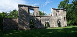
Ruins of the HermitageLocation Canada Nearest city Hamilton, Ontario Coordinates 43°14′15″N 79°59′38″W / 43.2375°N 79.99389°WCoordinates: 43°14′15″N 79°59′38″W / 43.2375°N 79.99389°W Area 1200 ha Established 1970 Governing body Hamilton Conservation Authority Dundas Valley Conservation Area is located on the Niagara Escarpment in Dundas, Ontario, a constituent community of Hamilton, Ontario, and is owned and operated by the Hamilton Conservation Authority. Its 40-kilometre trail system provides a connection to the Bruce Trail.[1] The area contains a trailhead of the Hamilton-Brantford-Cambridge Trails, Canada's first fully developed interurban multi-use trail system, which is a part of the Trans Canada Trail.[2]
Contents
Landform
The origins of the Dundas Valley, the main feature of the area, date back to the pre-glacial times, when the Niagara Escarpment was deeply incised by erosion.[3] The Wisconsin Glaciation furthered the erosion processes and resulted in deposition of glacial and glaciolacustrine sediments, forming the hummocky kame and kettle topography of the present.[4]
Cultural heritage
Sulphur Springs Hotel
A sulphurous spring found in the area was the site of the Sulphur Springs Hotel built during the late 1880s. As sulphur was believed to possess wondrous curative powers, the hotel's mineral spa was a very popular summertime destination.[5] The hotel closed down in 1910 after it was ravaged by two fires. The spring flows from a fountain first built in 1820 from cast iron. In 1850, it was replaced by a cement fountain. Having crumbled, it was restored in 1972.
The Hermitage
Further information: The Hermitage (Ontario)A magnificent stone mansion was built in 1855 by George Gordon Browne Leith, an immigrant from Scotland. Construction materials were obtained locally. Bricks originated from the Dundas Valley clay; limestone was quarried at the Credit River valley.[5] The Hermitage burned down in 1934. After that, Leith's daughter built a much smaller house among the ruins and lived there until her death in 1942. To prevent further deterioration, the ruins were stabilized using wooden braces.
Trail Centre
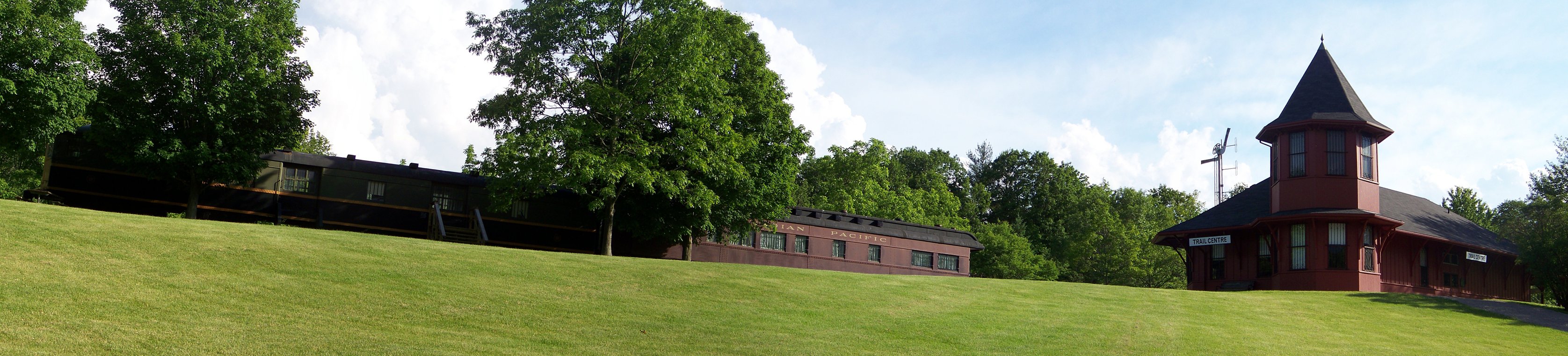
 The Trail Centre.
A modern replica of a Victorian railway station serves as the area's Trail Centre. Adjacent to it is a remnant of the Toronto, Hamilton and Buffalo Railway track with a 1929 executive coach car and a 1931 baggage car donated by the Canadian Pacific Railway. The track was converted into an interurban rail trail, having been abandoned in 1988.
References
- ^ "Dundas Valley Conservation Area Brochure". Hamilton Conservation Authority. http://www.conservationhamilton.ca/Asset/iu_files/DundasValleyBrochure04.pdf. Retrieved 2008-08-10.[dead link]
- ^ "Rail Trail Link Brochure". Hamilton Conservation Authority. http://www.conservationhamilton.ca/Asset/iu_files/RailTrailBrochure.pdf. Retrieved 2008-08-10.
- ^ "Dundas Valley". Carolinian Canada. http://www.carolinian.org/CarolinianSites_Dundas.htm. Retrieved 2008-08-10.
- ^ "Natural Areas Report: DUNDAS VALLEY FORESTS". Ontario Ministry of Natural Resources. 2008-06-27. http://nhic.mnr.gov.on.ca/areas/areas_report.cfm?areaid=3. Retrieved 2008-08-10.[dead link]
- ^ a b "Dundas Valley Conservation Area - Main loop Trail Guide". Hamilton Conservation Authority. http://www.conservationhamilton.ca/Asset/iu_files/MainLoopTrailGuide04.pdf. Retrieved 2008-08-10.[dead link]
External links
Categories:- Conservation areas in Ontario
- Niagara Escarpment

Wikimedia Foundation. 2010.