Chestnut and The Embarcadero Station

Chestnut and The Embarcadero Station
Chestnut and The Embarcadero
Muni heritage railway
Chestnut and The Embarcadero.JPG
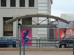
Station statistics
Address The Embarcadero at Chestnut and Sansome Streets
San Francisco, California
Lines

Muni

Platforms Two side platforms
Other information
Accessible Handicapped/disabled access
Services
Preceding station   Muni heritage railway   Following station
F Market & Wharves
toward 17th and Castro

Chestnut and The Embarcadero Station is a light rail station in San Francisco, California, serving the San Francisco Municipal Railway's F Market & Wharves heritage railway line. It is located on The Embarcadero at Chestnut and Sansome Streets.

Coordinates: 37°48′18.44″N 122°24′11.55″W / 37.8051222°N 122.4032083°W / 37.8051222; -122.4032083


Wikimedia Foundation. 2010.

Игры ⚽ Поможем написать курсовую

Look at other dictionaries:

  • F Market & Wharves — Infobox rail line name = F Market Wharves color = f0e68c image width = 250px caption = Car 130 at Jones Street Terminal. type = Heritage streetcar system = San Francisco Municipal Railway status = locale = San Francisco, California start = Jones… …   Wikipedia

  • List of defunct San Francisco Municipal Railway lines — This is a list of defunct San Francisco Municipal Railway bus, streetcar/light rail, and cable car routes. Contents 1 Defunct bus routes 2 Defunct streetcar routes 2.1 A Geary 10th Avenue …   Wikipedia

  • Street running — This article is about railways in towns. For the physical activity, see Parkour. For the long distance sport, see road running. Darjeeling Toy train in Kurseong, India On street running or street running is when a railroad track or tramway track… …   Wikipedia

  • National Register of Historic Places listings in Alameda County, California — Map of all coordinates from Google Map of all coordinates from Bing …   Wikipedia

Share the article and excerpts

Direct link
Do a right-click on the link above
and select “Copy Link”