- Conover Beacon
-
Conover Beacon 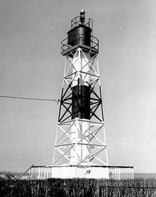
the present tower (USCG) Location Leonardo, New Jersey Coordinates 40°25′17″N 74°03′20″W / 40.4213°N 74.0556°WCoordinates: 40°25′17″N 74°03′20″W / 40.4213°N 74.0556°W Year first lit 1856 (orig.)
1941 (current)Deactivated 1988 Construction Wood (orig.)
Steel (current)Tower shape hexagonal (orig.)
skeletal w/cylinder (current)Height 55 ft (orig.)
45 ft (current)The Conover Beacon is a lighthouse in Leonardo, New Jersey that functioned as the front light of the now-discontinued Chapel Hill Range.
History
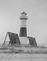 the original tower
The Chapel Hill Channel provides a north-south connection between the Ambrose Channel (the main channel into the Narrows) and Sandy Hook Channel, which continues west into Raritan Bay. This channel was marked, beginning in 1856, by range lights, named after the hill on which the original rear light stands. The original front beacon was a hexagonal wooden tower built at the edge of the beach in Leonardo, New Jersey. The land on which the light stood was purchased from Rulif Conover, who thus lent his name to the finished beacon.
The original tower stood until 1941, though the light was discontinued for several months in 1923, only to be restored after protests. In 1941 the front range tower from the Waackaack Range was moved to a spot adjacent to the old tower, and it served as the front light for the range until discontinuance in 1988. This skeletal tower with a central shaft remains in place, and is managed by Middletown Township, New Jersey. Both the old and the new towers used the same daymark: a red band on a white tower.
See also
References
- "Historic Light Station Information and Photography: New Jersey". United States Coast Guard Historian's Office. http://www.uscg.mil/history/weblighthouses/LHNJ.asp. Retrieved 2008-07-13.
- "Conover Beacon Lighthouse". Lighthousefriends.com. http://www.lighthousefriends.com/light.asp?ID=377. Retrieved 2008-07-13.
- NOAA Office of Coast Survey (1988). Chart 12401: New York Lower Bay (Southern Part) (Map). 1:15,000. http://historicalcharts.noaa.gov/tiled_jpgs_done/zoomifyURLDrivenWebPage.htm?zoomifyImagePath=12401-6-1988. Retrieved 2008-07-13.
- "Inventory of Historic Light Stations: New Jersey Lighthouses: Conover Beacon (Chapel Hill Front Range)". National Park Service. http://www.nps.gov/history/Maritime/light/conover.htm. Retrieved 2008-07-13.
- "Conover Beacon - Leonardo, NJ". New Jersey Lighthouse Society. http://www.njlhs.org/njlight/conover.html. Retrieved 2008-07-13.
Lighthouses of New Jersey Absecon Light • Barnegat Lighthouse • Brandywine Shoal Light • Brigantine Lighthouse • Cape May Light • Chapel Hill Rear Range Light • Conover Beacon • Cross Ledge Light • East Point Light • Elbow of Cross Ledge Light • Finns Point Range Light • Great Beds Light • Hereford Inlet Light • Ludlam's Beach Light • Miah Maull Shoal Light • Navesink Twin Lights • Robbins Reef Light • Romer Shoal Light • Sandy Hook Light • Sea Girt Light • Ship John Shoal Light • Tinicum Island Rear Range Light Categories:
- Lighthouses in New Jersey
- Buildings and structures in Monmouth County, New Jersey
- Buildings and structures completed in 1941
- 1856 establishments in the United States
- Middletown Township, New Jersey
Wikimedia Foundation. 2010.