- Cape May Light
Infobox Lighthouse
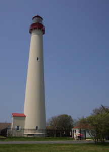
caption = Cape May Lighthouse
location =Cape May Point, New Jersey
coordinates = coord|38|55|59|N|74|57|37|W|region:US_type:landmark
yearlit = 1859
automated = 1946
yeardeactivated = Active
foundation = Surface rock
construction = Brick, White tower, red cupola
shape = Conical
height = 157 feet (48 m) (165 ft above sea level)
lens =Fresnel lens
range = 24 nm (44 km)
characteristic = White, Flashes every 15 secThe Cape May Lighthouse is a
lighthouse located inNew Jersey at the tip ofCape May , inCape May Point State Park , located in the town of Cape May Point. It was built in1859 , was automated in 1946, and continues operation to this day. It is the third fully documented lighthouse to be built at Cape May Point. The first was built in 1823; the second in 1847. The exact locations of the first two lighthouses are now underwater due to erosion. There are 199 steps to the top of the Lighthouse. The view from the top extends to Cape May City and Wildwood to the north, Cape May Point to the south, and, on a clear day,Cape Henlopen , Delaware, to the west.The lighthouse is owned by the
United States Coast Guard , which maintains it as an active aid to maritime navigation. The Coast Guard leases the structure and the grounds (but not the navigation equipment) to the State of New Jersey which, in turn, sub-leases the structure and grounds to the Mid-Atlantic Center for the Arts (MAC). MAC raises funds for the restoration and upkeep of the structure and allows visitors to climb to the top. On the way, MAC has placed interpretive exhibits about the lighthouse's history, the lives of the former keepers, and other maritime history of the Jersey Cape.The tower is 157 feet 6 inches tall, from the ground to the tower's cast iron spiral staircase. There are 217 steps from the ground to the top, with 199 steps in the tower's cast iron spiral staircase. The lighthouse has two separate walls. The outside wall is cone-shaped, and is 3 feet 10 inches thick at the bottom, and 1 foot 6 inches thick at the top. The inside wall is cylinder with 8.5-inch thick walls which support the spiral staircase. The walls were designed to withstand winds several times above hurricane force.
External links
* [http://www.cr.nps.gov/maritime/light/capemay.htm National Park Service] - Inventory of Historic Light Stations
* [http://www.capemaymac.org/Lighthouse/this-week-in-cape-may-lighthouse.htm Mid-Atlantic Center for the Arts]
* [http://www.lighthousefriends.com/light.asp?ID=389 Lighthousefriends.com]Gallery
Wikimedia Foundation. 2010.