- Cobija
-
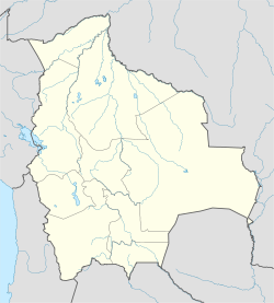
Cobija Location in Bolivia Coordinates: 11°02′S 68°44′W / 11.033°S 68.733°W Country  Bolivia
Department  Pando Department
Province Nicolás Suárez Founded 1906 Government - Mayor Luís Adolfo Flores Roberts Elevation 919 ft (280 m) Population - Total 25,000 (est) Time zone UTC-4 Website http://www.gmcobija.gob.bo/ The Bolivian city of Cobija is located about 600 km (373 mi.) north of La Paz in the Amazon Basin on the border of Brazil and Peru. Cobija lies on banks of the Rio Acre across from the Brazilian city Brasiléia. Cobija lies at an elevation of ca. 280 m (920 ft.) above sea level and has a tropical and rainy climate.
Cobija has approximately 25,000 inhabitants, is the seat of a university and capital of the Bolivian Pando Department. Cobija has two airports and is connected by one road to El Choro in the Beni Department, which is not always passable during the rainy season.
History
Cobija was founded in 1906 by Colonel Enrique Cornejo, originally under the name of Bahía and received its current name in 1908 in commemoration of the former Bolivian seaport Cobija (Lamar) on the Pacific, the site of which is on territory now belonging to Chile since the War of the Pacific. In the early 1900s, Cobija experienced a boom as a India rubber industry center. When the industry collapsed, a major source of income being lost, Cobija became impoverished and its population greatly decreased. Currently, the region's primary industry is Brazil nuts.
Climate
The city of Cobija sits on a sharp curve of the Acre river. Located at an altitude of 280 meters above sea level and in the northwestern jungle region – in Brazilian border – Cobija is considered the rainiest region in Bolivia. It is also a very hot spot, with temperatures above 26 degrees Celsius (80 Fahrenheit) most of the time.
External links
Coordinates: 11°02′S 68°44′W / 11.033°S 68.733°W
Categories:- Populated places in the Pando Department
- Populated places established in 1906
- Bolivia–Brazil border crossings
- Bolivia geography stubs
Wikimedia Foundation. 2010.

