- Mines of Spain State Recreation Area and E. B. Lyons Nature Center
-
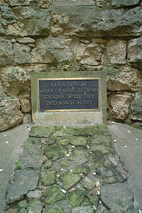
Mines of Spain State Recreation Area and E. B. Lyons Nature Center Iowa State Park Julien Dubuque's monumentNamed for: Julien Dubuque's Mines Country  United States
State  Iowa
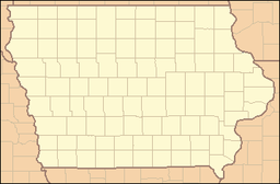
IowaCounty Dubuque Location Dubuque - elevation 751 ft (229 m) [1] - coordinates 42°27′45″N 90°39′45″W / 42.4625°N 90.6625°W Area 1,380 acres (558 ha) Founded 1981 Management Iowa Department of Natural Resources The Mines of Spain State Recreation Area and E. B. Lyons Nature Center is a state park in Dubuque County, Iowa, USA. It is near Dubuque, the eighth-largest city in the state. The park features picnic areas, 15 miles (24 km) of walking/hiking trails, 4 miles (6.4 km) of ski trails, and the Betty Hauptli Bird and Butterfly Garden.
Contents
History
Meskwaki Indians were believed to be the first people in the area, residing in the area for up to 8000 years previous to discovery by Julien Dubuque, believed to be the first European to set foot in Iowa. The Meskwaki had been trading furs with French Voyageurs, as well as mining lead in the area. The Governor of Spain gave Dubuque a grant to work Spanish-owned land, naming the 1,380-acre (560 ha) area The Mines of Spain. Mining would continue by the Meskwaki, then by European settlers until 1914.
Unique features
From a horseshoe-shaped area, Horseshoe Bluff, the geology of the area is visible. Ordovician dolomite is evident, and two trails lead to a blind.
References
- ^ "Mines of Spain State Park". Geographic Names Information System. United States Geological Survey. 2000-01-01. http://geonames.usgs.gov/pls/gnispublic/f?p=gnispq:3:::NO::P3_FID:463773. Retrieved 2011-02-27.
External links
- Mines of Spain State Recreation Area and E. B. Lyons Nature Center
- Friends of The Mines of Spain - Nature center information
Protected Areas of Iowa Federal DeSoto • Driftless Area • Neal Smith • Northern Tallgrass Prairie • Port Louisa • Union Slough • Upper Mississippi River
State Ambrose A. Call • Backbone • Badger Creek • Banner Lakes at Summerset • Beed's Lake • Bellevue • Big Creek • Black Hawk • Brushy Creek • Cedar Rock • Clear Lake • Dolliver Memorial • Elk Rock • Elinor Bedell • Emerson Bay • Fairport • Fort Defiance • Geode • George Wyth Memorial • Green Valley • Gull Point • Honey Creek • Lacey-Keosauqua • Lake Ahquabi • Lake Anita • Lake Darling • Lake Keomah • Lake MacBride • Lake Manawa • Lake of Three Fires • Lake Wapello • Ledges • Lewis and Clark • Maquoketa Caves • Marble Beach • McIntosh Woods • Mines of Spain & E.B. Lyons • Mini-Wakan • Nine Eagles • Okamanpedan • Palisades-Kepler • Pikes Peak • Pikes Point • Pilot Knob • Pine Lake • Pleasant Creek • Prairie Rose • Preparation Canyon • Red Haw • Rice Lake • Rock Creek • Springbrook • Stone • Templar • Trapper's Bay • Twin Lakes • Union Grove • Viking Lake • Volga River • Walnut Woods • Wapsipinicon • Waubonsie • Wildcat Den • Wilson Island
Backbone • Barkley • Gifford • Holst • Loess Hills • Pilot Mound • Shimek • Stephens • White Pine Hollow • Yellow River
A.F. Miller • Ames High Prairie • Anderson Prairie • Behrens Pond and Woodlands • Berry Woods • Bird Hill • Bixby • Bluffton Fir Stand • Brush Creek Canyon • Brushy Creek • Cameron Woods • Casey's Paha • Catfish Creek • Cayler Prairie • Cedar Bluffs • Cedar Hills Sand Prairie • Cheever Lake • Clay Prairie • Claybanks Forest • Cold Water Spring • Crossman Prairie • Decorah Ice Cave • Dinesen Prairie • Doolittle Prairie • Fallen Rock • Fish Farm Mounds • Five Ridge Prairie • Fleming Woods • Fort Atkinson • Freda Haffner Kettlehole • Gitchie Manitou • Hanging Bog • Hardin City Woodland • Hartley Fort • Hayden Prairie • Hoffman Prairie • Indian Bluffs Primitive Area • Indian Fish Trap • Iowa's State Preserves System • Kalsow • Kish-Ke-Kosh Prairie • Lamson Woods • Liska-Stanek Prairie • Little Maquoketa • Malanaphy Springs • Malchow Mounds • Manikowski Prairie • Mann Wilderness Area • Marietta Sand Prairie • Mericle Woods • Merrill A. Stainbrook • Merritt Forest • Montauk • Mossy Glen • Mount Pisgah Cemetery • Mount Talbot • Nestor Stiles Prairie • Ocheyedan Mound • Old State Quarry • Palisades-Downs • Pecan Grove • Pellett Woods • Pilot Grove • Pilot Knob • Retz Woods • Roberts Creek • Rock Creek Island • Rock Island • Roggman Boreal Slopes • Rolling Thunder Prairie • Saint James Lutheran Church • Savage Woods • Searryl's Cave • Sheeder Prairie • Silver Lake Fen • Silvers-Smith Woods • Slinde Mounds • Starr's Cave • Steele Prairie • Stinson Prairie • Strasser Woods • Sylvan Runkel • Toolesboro Mounds • Turin Loess Hills • Turkey River Mounds • White Pine Hollow • Williams Prairie • Wittrock Indian Village • Woodland Mounds • Woodman Hollow • Woodthrush •
County State Parks
(Leased)Bobwhite • Cold Springs • Crystal Lake • Eagle Lake • Echo Valley • Frank A. Gotch • Heery Woods • Lake Cornelia • Lake Icaria • Kearny • Margo Frankel • Mill Creek • Oak Grove • Oakland Mills • Pammel • Sharon Bluffs • Spring Lake • Swan Lake • Three Mile Lake
Categories:- Iowa state parks
- Nature centers in Iowa
- Protected areas on the Mississippi River
- Protected areas established in 1981
- Protected areas of Dubuque County, Iowa
Wikimedia Foundation. 2010.


