Granite Dells

Granite Dells
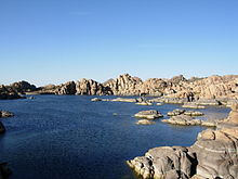
Watson Lake in the Granite Dells
Dells Granite showing spheroidal weathering.

The Granite Dells is a geological feature north of Prescott, Arizona. The Dells consist of exposed bedrock and large boulders of granite that have eroded into an unusual lumpy, rippled appearance. Watson Lake and Willow Lake are small man-made reservoirs in this formation; these, combined with numerous hiking & biking trails and rockclimbing routes, make it a popular outdoor recreation area in the region.

The Peavine National Recreation Trail follows the old railbed of the Santa Fe, Prescott and Phoenix Railway through the Granite Dells. This winding portion of the railroad was known as the "Peavine" because its twisting curves resembled that of a pea vine. [1]It connects to the Iron King Trail [2], which follows the route of the old Prescott and Eastern Railroad through the eastern Granite Dells. Both are rail to trail conversions.

Geology

The Dells Granite has been dated at 1.4 billion years old. Its pluton was intruded at a depth of around one or two miles (1.6 to 3.2 km). These cover rocks have since been eroded away. Weathering along joints produced the rounded boulders and other unusual rock formations that characterize the Granite Dells. This process is called spheroidal weathering, and is common in granitic terrains. [3]

The Dells Granite has an unusually high uranium content, and thus homes built over the granite should be checked for radon leaking from the granite. [3]

References

  1. ^ Peavine Trail
  2. ^ Iron King trail
  3. ^ a b Prescott Area Geological Field Guide, 1999, prepared for Earth Science Week. Copy available at Yavapai College library.

External links


Wikimedia Foundation. 2010.

Игры ⚽ Поможем решить контрольную работу

Look at other dictionaries:

  • List of mountain ranges of Arizona — There are 194 named mountain ranges in Arizona. The extra items listed may include::Mingus Mountain, the high, NW section of the Black Hills:Shiprock:Sierra Madre Occidental (of W continental Mexico) The list*Agua Caliente Mountains ndash;Yuma… …   Wikipedia

  • Watson Lake (Arizona) — Infobox lake lake name = Watson Lake image lake = Watson Lake 2.jpg caption lake = The diversion dam can be see on the left. image bathymetry = caption bathymetry = location = Yavapai County, Arizona coords =… …   Wikipedia

  • Prescott, Arizona — Infobox Settlement official name = Prescott, Arizona settlement type = City image caption = Prescott Gurley Street in 1940s imagesize = 250x250px image image caption = Prescott Gurley Street in 1940s imagesize = 250x250px image mapsize =… …   Wikipedia

  • Kartchner Caverns State Park — (coord|31|50|164|N|110|20|929|W) is an Arizona state park, located nine miles (14 km) south of the town of Benson (near Tucson) and is considered by many to be the crown jewel of Arizona s state park system.The park encompasses most of a down… …   Wikipedia

  • Raw Spirit Festival — Infobox festival festival name = Raw Spirit Festival logo = caption = location = Sedona, Arizona years active = 2005 present dates = genre = website = http://www.rawspirit.com/Raw Spirit Festival, Inc. is a 501c3 non profit educational,… …   Wikipedia

  • Kartchner Caverns State Park — Die Höhle Big Room in den Kartchner Caverns. Der Kartchner Caverns State Park ist ein State Park im US Bundesstaat Arizona. Er liegt 14 km südlich des Ortes Benson beziehungsweise rund 90 km südöstlich der Stadt Tucson und gilt als… …   Deutsch Wikipedia

  • Leave Her to Heaven — Filmdaten Deutscher Titel: Todsünde Originaltitel: Leave Her to Heaven Produktionsland: USA Erscheinungsjahr: 1945 Länge: ca. 105 Minuten Originalsprache: Englisch …   Deutsch Wikipedia

  • Todsünde (Film) — Filmdaten Deutscher Titel: Todsünde Originaltitel: Leave Her to Heaven Produktionsland: USA Erscheinungsjahr: 1945 Länge: ca. 105 Minuten Originalsprache: Englisch …   Deutsch Wikipedia

  • Todsünde (1945) — Filmdaten Deutscher Titel Todsünde Originaltitel Leave Her to Heaven Produ …   Deutsch Wikipedia

  • List of reservoirs and dams in the United States — There are an estimated 75,000 dams in the United States, blocking 600,000 miles (960,000 km) of river or about 17% of rivers in the nation . [cite web|url=http://www.pcffa.org/dams.htm |title=Dams and salmon |accessdate=2008 02 11] The following… …   Wikipedia

Share the article and excerpts

Direct link
Do a right-click on the link above
and select “Copy Link”