- Plaridel, Quezon
-
Plaridel — Municipality — Map of Quezon showing the location of Plaridel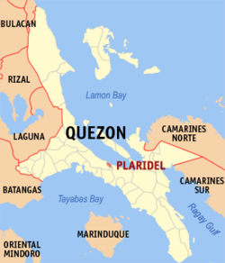 Location in the Philippines
 Plaridel
Coordinates: 13°57′4″N 122°1′13″E / 13.95111°N 122.02028°ECoordinates: 13°57′4″N 122°1′13″E / 13.95111°N 122.02028°E Country  Philippines
Region CALABARZON (Region IV) Province Quezon District 4th distrinct of Quezon Founded Barangays 9 Government – Mayor Wilfredo M. Magbuhos Jr. Area – Total 33.05 km2 (12.8 sq mi) Population (2007) – Total 10,069 – Density 304.7/km2 (789.1/sq mi) Time zone PST (UTC+8) ZIP code Income class 5th class; partially urban Plaridel is a 5th class municipality in the province of Quezon, Philippines. According to the 2007 census, it has a population of 10,069 people[1].
Contents
Geography and Demography
The smallest municipality in the province of Quezon, Plaridel has an area of 33 square kilometers comprising nine barangays - four of which are poblaciones - and its population is around 11, 000. It lies between the towns of Atimonan and Gumaca, hugging the coastline of the Province alongside Maharlika Highway. Its inhabitants are occupied primarily with fishing. Those engaged inAgriculture plant mostly coconut and rice. A visitor this town must taste and savor its local version of Suman.
Government
Municipal Officials
- Mayor: Hon. Wilfredo M. Magbuhos Jr.
- Vice Mayor: Hon. Bernard V. Tumagay
- Councilors:
- Hon. Robert L. Magbuhos
- Hon. Sixto A. Alva
- Hon. Nemesio A. Alvarez
- Hon. Medel V. Pensona
- Hon. Romeo A. Jaravata
- Hon. Razel V. Espos
- Hon. Carlos L. Campomanes
- Hon. Sofia A. Capayas
Barangays
Plaridel is politically subdivided into 9 barangays.
- Concepcion
- Duhat
- Ilaya
- Ilosong
- Tanauan
- Central (Pob.)
- Paang Bundok (Pob.)
- Paaralan or Pampaaralan (Pob.)
- M. L. Tumagay (Pob.)
Barangays Duhat, Ilaya, and Ilosong are south of the Poblacion, and are accessed by a paved road which connects with the National Maharlika Highway at Brgy. Pampaaralan (also called Paaralan). This road is also the main access to Brgy. Kulawit, part of the Municipality of Atimonan to the west.
Notes
- ^ "2007 Census of Population". Philippine National Statistics Office. http://www.census.gov.ph/data/census2007/index.html. Retrieved 2008-10-04.
External links
- An Act Creating the Municipality of Plaridel in the Province of Quezon
- Philippine Standard Geographic Code
- 2000 Philippine Census Information
- http://erintanada.com/quezondistrict.html
Municipalities - Agdangan
- Alabat
- Atimonan
- Buenavista
- Burdeos
- Calauag
- Candelaria
- Catanauan
- Dolores
- General Luna
- General Nakar
- Guinayangan
- Gumaca
- Infanta
- Jomalig
- Lopez
- Lucban
- Macalelon
- Mauban
- Mulanay
- Padre Burgos
- Pagbilao
- Panukulan
- Patnanungan
- Perez
- Pitogo
- Plaridel
- Polillo
- Quezon
- Real
- Sampaloc
- San Andres
- San Antonio
- San Francisco
- San Narciso
- Sariaya
- Tagkawayan
- Tiaong
- Unisan
Component city Highly urbanized city - Lucena
Categories:- Municipalities of Quezon


Wikimedia Foundation. 2010.