- 2008 Peloponnese earthquake
Earthquake
title=2008 Peloponnese earthquake
date=June 8 ,2008 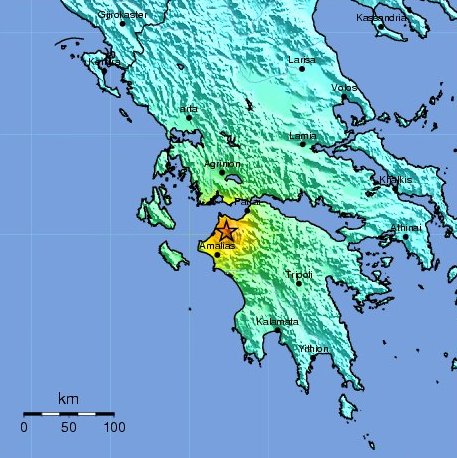
magnitude = 6.5 Mw
depth=6.2 miles (10 km)
location=38.029°N, 21.464°E
countries affected = Flag|Greece
intensity = VIII - Destructive [ [http://earthquake.usgs.gov/eqcenter/pager/events/us/2008taaw/index.html M 6.3 - SOUTHERN GREECE ] ]
casualties = 2 dead; 227 injuredThe 2008 Peloponnese earthquake was a deadlyearthquake that killed two people, injured more than 220 and left at least 2,000 people homeless in north westernPeloponese onJune 8 ,2008 . The earthquake hit the area at 1525 EET (1325 UTC), with a moment magnitude of 6.5, according to the Athens Geodynamic Institute. It was strongly felt as far away as inAthens and in parts of southernItaly . [cite web
title = Quake fears force Greek villages to evacuate
work =
publisher =CNN
date =2008-06-09
url =http://edition.cnn.com/2008/WORLD/europe/06/09/greece.quake.ap/
accessdate =2008-06-09 ] TheUS Geological Survey reported that the quake had a magnitude of 6.3. [http://earthquake.usgs.gov/eqcenter/recenteqsww/Quakes/us2008taaw.php "Magnitude 6.3 - Greece"] Earthquake Hazards Program, United States Geological Survey] The epicenter of the tremor was located about 15 miles (32 km) southwest of the Greek port city ofPatras , at a depth of 10 km. Interior MinisterProkopis Pavlopoulos dispatched rescue and recovery teams (including members of five government agencies), theRed Cross and units of the army in order to assess the damage and the needs of survivors in the earthquake affected areas. [cite web
title = Strong earthquake jolts Greece
work =
publisher =CNN
date =2008-06-08
url =http://www.cnn.com/2008/WORLD/europe/06/08/greece.quake/index.html
accessdate =2008-06-08 ] [cite web
title = Two killed by large Greek quake
work =
publisher =BBC
date =2008-06-08
url =http://news.bbc.co.uk/1/hi/world/europe/7442705.stm
accessdate =2008-06-08 ]Tectonic summary
According to the USGS: [ [http://earthquake.usgs.gov/eqcenter/eqinthenews/2008/us2008taaw/#summary Magnitude 6.3 - GREECE ] ]
The earth's crust and lithosphere in the eastern Mediterranean constitute a broad boundary region between three major tectonic plates, the Eurasia, Africa, and Arabia plates. The motions of these major plates drive smaller microplates, and it is the shapes and motions of these smaller plates that determine the locations and focal mechanisms of most intraplate earthquakes in the region.
The earthquake of June 8, 2008, was generated by stresses resulting from the motion of the small Aegean Sea plate southwest with respect to the Eurasia plate with a velocity of about 30 mm/y. The boundary between the Aegean plate and the Eurasia plate in central Greece is diffuse. Seismicity is concentrated in east-trending and northeast-trending zones of deformation. The east-trending zones are characterized by predominantly normal faulting. The northeast-trending zones are characterized by predominately strike-slip faulting earthquakes. The focal-mechanism of the earthquake of June 8 is consistent with the shock having been caused by strike-slip faulting similar to that occurring within the northeast-trending zones. Since the beginning of the twentieth century, the largest crustal earthquakes of central Greece have had magnitudes of about 7.2.
References
ee also
*
2006 Southern Greece earthquake
*2008 Dodecanese earthquake
Wikimedia Foundation. 2010.