- Cuenca, Batangas
-
Cuenca
Bayan ng Cuenca
Munisipalidad ng Cuenca
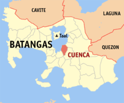
pueblo de Cuenca— Municipality — Nickname(s): Home of the Bakers Map of Batangas showing the location of Cuenca. Location in the Philippines Coordinates: 13°55′00″N 121°02′41″E / 13.9166667°N 121.04472°ECoordinates: 13°55′00″N 121°02′41″E / 13.9166667°N 121.04472°E Country Region CALABARZON (Region IV-A) Province Batangas District 3rd District Founded 1877 Barangays 21 Government - Mayor Edmund Remo Area - Total 58.18 km2 (22.5 sq mi) Population (2007) - Total 28,581 - Density 491.3/km2 (1,272.3/sq mi) Demonym Cuencano/Cuencana/taga-Cuenca Time zone PST (UTC+8) ZIP code 4222 Income class 4th class Population Census of Cuenca Census Pop. Rate 1995 22,758 — 2000 25,642 2.59% 2007 28,581 1.51% Cuenca is a 4th class municipality in the province of Batangas, Philippines. According to the latest census, it has a population of 28,581 people in 5,222 households.
Once a part of San Jose it became an independent town under the name of "Cuenca" in 1876. Its famous tourist attraction Mt. Maculot (600 m or 1968 ft.).
The Patron of Cuenca is Saint Isidore the Laborer, the patron of farmers celebrates his feast day during May. 15
Contents
History
Cuenca was founded in 1875 by the decree of the Superior Gobierno issued on August 11, 1875. Another document states the barrios of Maculot, Dita, Ibabao, Labac, Bungahan and Dalipit be constituted into one civil and independent town due to its distance from the town of San Jose.
In 1896, Cuenca had a population of 5,660, which increased to 6,938 in 1898. The town also played a role during World War II. Mt. Maculot became the strong hold of the Japanese forces in Batangas. They also built tunnels in some parts of Barangay Dita. During the Liberation, Cuenca was badly bombed which cause the deforestation of the slopes of the mountain. Rehabilitation was needed in order for the town to rise up from the ruins of the war. Local Filipino troops and officers of the 4th, 42nd and 45th Infantry Division of the Philippine Commonwealth Army and 4th Infantry Regiment of the Philippine Constabulary enters the liberated in Cuenca in 1944 to 1945 and helpul the local guerrilla resistance fighters and American liberation forces against the Japanese. Combined Filipino-American ground forces helped the town by rebuilding schools and bridges. A marker in Cuenca Central Elem. School shows the effort they did. Cuenca Institute was founded in 1947 in order to give secondary education and it is the oldest secondary institution in Cuenca. Back then, students who graduated elementary used to go to Batangas City or Manila and parents who could not afford to send their children to those places failed to give them a high school education. Cuenca became popular not only because of the mountain but to its number of bakers. In Manila, over 90% of all bakers come and started here, making Cuenca as "The Home Of The Bakers". Annually, festivals are made in honor of San Isidro Labrador.
Barangays
Cuenca is politically subdivided into 21 barangays. Don Juan was constituted as a barrio in 1954 from the sitios of Lungos ng Parang, Kulit, Lumampao, Pisa, Napapanayam and Lagundian.[1]
- Balagbag
- Bungahan
- Calumayin
- Dalipit East
- Dalipit West
- Dita
- Don Juan
- Emmanuel
- Ibabao
- Labac
- Pinagkaisahan
- San Felipe
- San Isidro
- Barangay 1 (Pob.)
- Barangay 2 (Pob.)
- Barangay 3 (Pob.)
- Barangay 4 (Pob.)
- Barangay 5 (Pob.)
- Barangay 6 (Pob.)
- Barangay 7 (Pob.)
- Barangay 8 (Pob.)
Gallery
References
External links
- Philippine Standard Geographic Code
- 1995 Philippine Census Information
- 2000 Philippine Census Information
- 2007 Philippine Census Information

Taal Lake Balete, Batangas Mataas na Kahoy, Batangas 
Taal Lake 
San José, Batangas  Cuenca, Batangas

Taal Lake Alitagtag Bauan, Batangas Municipalities Agoncillo • Alitagtag • Balayan • Balete • Bauan • Calaca • Calatagan • Cuenca • Ibaan • Laurel • Lemery • Lian • Lobo • Mabini • Malvar • Mataas na Kahoy • Nasugbu • Padre Garcia • Rosario • San Jose • San Juan • San Luis • San Nicolas • San Pascual • Santa Teresita • Santo Tomas • Taal • Talisay • Taysan • Tingloy • TuyComponent cities Categories:- Municipalities of Batangas
- Philippines geography stubs
Wikimedia Foundation. 2010.


