- Makilala, Cotabato
-
Makilala — Municipality — Municipality of Makilala, Cotabato Map of Cotabato showing the location of Makilala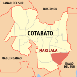 Location in the Philippines
 Makilala
Coordinates: 6°57′N 125°03′E / 6.95°N 125.05°ECoordinates: 6°57′N 125°03′E / 6.95°N 125.05°E Country Philippines Region SOCCSKSARGEN (Region XII) Province Cotabato Districts 2nd District of Cotabato Barangays 38 Incorporated (Town) September 8, 1954 Government – Type Mayor-Council – District Representative Nancy A. Catamco – Mayor CAOAGDAN, Rudy S. (2010-present) – Vice Mayor CUA, Ricky A. (2010-present) – Municipal Council CouncilorsArea – Total 343.5653 km2 (132.7 sq mi) Elevation 240 m (787.4 ft) Population (2009) – Total 71,543 – Density 208.2/km2 (539.3/sq mi) Demonym Cotabateños Time zone PST (UTC+8) – Summer (DST) +8 (UTC+8) ZIP Code 9401 Language(s) Manobo (official) Income class 1st Class[1] Makilala is a 1st class municipality in the province of Cotabato, Philippines. According LGPMS (as of 2009)[2], it has a population of 71,543 people in 14,592 households.
Contents
Geographical Location
The municipality of Makilala is located on the south-east portion of Cotabato Province and the last town going to Davao City. It is bounded by the municipality of Kidapawan in the North, Municipality of M’lang in the west, Province of Davao Del Sur in the south and the Municipality of Tulunan in the south-east.
It is 129 kilometers from Cotabato City, 100 kilometers from Davao City and 114 kilometers from General Santos City.
Barangays
Makilala is politically subdivided into 38 barangays.
- Batasan
- Bato
- Biangan
- Buena Vida
- Buhay
- Bulakanon
- Cabilao
- Concepcion
- Dagupan
- Garsika
- Guangan
- Indangan
- Jose Rizal
- Katipunan II
- Kawayanon
- Kisante
- Leboce
- Libertad
- Luayon
- Luna Norte
- Luna Sur
- Malabuan
- Malasila
- Malungon
- New Baguio
- New Bulatukan
- New Cebu
- Old Bulatukan
- Poblacion
- Rodero
- Saguing
- San Vicente
- Santa Felomina
- Santo Niño
- Sinkatulan
- Taluntalunan
- Villaflores
- New Israel
Climate
Makilala's climatic condition is characterized by rainfall evenly distributed throughout the year, thus, keeps springs flowing, rivers alive and farms productive. Presence of Mt. Apo, Mt. Libadan, Mt. Gap and Mt. Niponggis serves as rain generators that provide reliable rainfall pattern and cool climate.
Natural Resources
Their agricultural land mostly planted with rubber, rice, coconut, coffee, bananan, vegetables and famous fruits such as durian, marang, rambutan and mangosteen.
Industries
Industries in Makilala are Rubber Industry, Woodworks and Agri-industrial products.
Major firms are STANFILCO-DOLE , engaged in cavendish production and rubber processing companies like STANDECO, FARMA, MRDI, PIONEER, LASRI, MRI, and DAVCO. Major wood processing company is RNF Summit.Also Makilala has First Community Radio Fm station Freedom Radio Makilala 107.9 fm
Tourist Attraction
- New Israel situated on the periphery of Mt. Apo National Park at an elevation of 1,600 feet above sea level. A barangay in Makilala which is well known for its numerous monkeys. This mountain village is home to a religious sect called the Moncadista.
- Flortam Hot Spring located at Makilala, Cotabato which is 5 kilometers from the national highway. A major tourist attraction and dubbed as *Fountain of Youth because of its healing power, thus, popular among old folks who have arthritis and rheumatism.
- Le Reve Resort located at National Highway, Makilala, Cotabato. An inland resort equipped with cottages, a restaurant, three (3) swimming pools with free flowing spring water from the foot of Mt. Apo.
- Sanga Ngawan Falls located at Batasan-Biangan, Makilala. A hot spring blessed with 2 natural pools.
- New Israel Eco-Tourism Park and Mini Zoo located at New Israel. It is surrounded by mountain ridges and blessed with natural grown trees and wild animals.
- Makalangit Camp located at New Israel, Makilala. Tourism adventure, holding camp to Mt. Apo via New Israel trail.
- Batasan-Biangan Hotspring Resort located at Batasan-Biangan, Makilala. Adventure tourism, swimming and trekking.
- Don Bosco Diocesan Youth Center located at Batasan, Makilala. Camping and picnic.
- Camps Cajelo and Aurora located at Makilala. Jamboree site/training center.
- Beauville Resort located in the municipality of Makilala. Lust over the wonders of cool water, indulge in the luxury of soaking in the pool covered by sun rays.
- Pool lake Located at Indongan, makilala- adventure,inland fishing.
History
The Municipality of Makilala which is a First Class municipality and formerly a baranggay with a name of “Lamitan”[3] was created by virtue of Executive Order No. 63 issued on September 8, 1954 by then President of the Philippines, Ramon Magsaysay.
Makilala is a Tagalog word meaning “To be Known” which is derived from the combination of the first syllables of the three big barrios of the area. These are Malasila, Kisante and Lamitan and an additional “la” was added to attain its Tagalog term.
References
External links
Municipalities Component city - Kidapawan
Categories:- Municipalities of Cotabato
- Philippines geography stubs


Wikimedia Foundation. 2010.