- Magpet, Cotabato
-
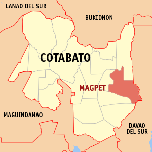
Magpet — Municipality — Municipality of Magpet, Cotabato Map of Cotabato showing the location of Magpet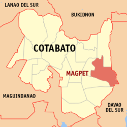 Location in the Philippines
 Magpet
Coordinates: 7°07′N 125°07′E / 7.117°N 125.117°ECoordinates: 7°07′N 125°07′E / 7.117°N 125.117°E Country Philippines Region SOCCSKSARGEN (Region XII) Province Cotabato Districts 2nd District of Cotabato Barangays 32 Incorporated (Town) June 22, 1963 Government - Type Mayor-Council - District Representative Nancy A. Catamco - Mayor PIÑOL, Efren F. (2010–present) - Vice Mayor VILLASOR, Florentino R. (2010–present) - Municipal Council CouncilorsArea - Total 755.36 km2 (291.6 sq mi) Elevation 300 m (984 ft) Population (2009) - Total 44,372 - Density 58.7/km2 (152.1/sq mi) Demonym Cotabateños
MagpeteñosTime zone PST (UTC+8) - Summer (DST) +8 (UTC+8) ZIP Code 9404 Language(s) Manobo (official) Income class 1st[1] Magpet is a 1st class municipality in the province of Cotabato, Philippines. According LGMPS[2] (as of 2009), it has a population of 44,372 people in 9,200 households.
Contents
Geography
Magpet is located in the eastern part of Cotabato province and in the foothills of Mt Apo with generally slopping and mountainous terrain. It is bordered in the south by Kidapawan City and on the north by the Municipality of Arakan.
Barangays
Magpet is politically subdivided into 32 barangays.
- Alibayon
- Bagumbayan
- Bangkal
- Bantac
- Basak
- Binay
- Bongolanon
- Datu Celo
- Del Pilar
- Doles
- Gubatan
- Ilian
- Inac
- Kamada
- Kauswagan
- Kisandal
- Magcaalam
- Mahongcog
- Manobo
- Noa
- Owas
- Pangao-an
- Poblacion
- Sallab
- Tagbac
- Temporan
- Amabel
- Balete
- Don Panaca
- Imamaling
- Kinarum
- Manobisa
Natural resources
Water
Several rivers located in Magpet are being tapped for irrigation development and potential for hydro power plants. Others are the major tributaries to Kabacan River, which flows to many barangays of Magpet, to the Municipalities of Pres. Roxas, Matalam, Kabacan, Carmen and connects with Pulangi River. As a major source of water supply, it served for irrigation purposes, servicing thousands of hectares of rice fields not only in the Municipality of Magpet, but also in the various areas of the Province as well. Magpet is serviced with public water system (Level III) by the Metro Kidapawan Water District. Under this system, 1,242 households were connected with individual faucet. The Barangay Water Sanitation, or BAWASA, has a communal faucet (Level II) connected to 2,381 households. 2,978 households draw their water from developed springs (Level I).
Minerals
Mineral products found in the municipality of Magpet include non-metallic like limestone, sand and gravel which are the basic good materials for constructions while the red and white clay, considered as among the best in the country, are good materials for ceramic production. These can be found particularly in the barangays of Doles, Inca and Noa. Metallic minerals include gold, nickel and silver.
Tourist attractions
- Towsuvan Falls located at the foothills of Mt. Apo in the town of Magpet. Crystal-clear water that offer a cool respite to a trek through lush forests, with more or less 20–30 meters drop of water with a natural pool. Its temperature reached up to 6 °C at night.
- Kirongdong Falls and Rainforests located at Kinarum, Magpet. More or less 70–80 meters drop of water surrounded by mountain ranges and cliffs.
- Mabu Falls and Rainforest located at Manobo, Magpet. More or less 400 ft high waterfalls and blessed with bed of flowers and century Cinnamon and Almaciga trees in the surroundings.
- Grace Tropical Resort located at Pangao-an, Magpet. A 3-hectare orchard.
- Manobo Tribal Village locatec at Manobo, Magpet. It is one of the entry point to Mt. Apo via Lake Venado.
- Dallag Tribal Village located at Manobo, Magpet. It has an area of 400 has. and nestled at about 400 above sea level and it is inhabited with indigenous Manobo tribes.
History
Magpet derived its name from the word “Malotpot”[3] which means “a place where people gather in fellowship to partake of their packed lunch wrapped in banana leaves”.
An anonymous lexicographer inadvertently shortened the word “Linoppot” to “Maupot”. Much later and further spelled into “MAGPET” by a certain forester in his survey report. Consequently, the word “Magpet” stuck not only to mean the place but also the stream of the cool, fresh and clean water. By the present connotation, Magpet means “the verdant lands of countless waters”.
The life of the early year’s settlers and inhabitants of Magpet was a tale of survival and fortitude. Their lives were always in danger. Bloodthirsty malarial mosquito’s attacked them. Grandparents often told their grandchildren the stories “about eating their meals inside the mosquito nets” because “mosquitoes were as big as bees”.
Yet, all the hardships and suffering, and even death of the early settlers only served to strengthen their decision to stay and utilize the vast natural resources of Magpet. The land was very fertile and varieties of fishes were found in the rivers and streams, and on the woodlands, wild pigs, deer and birds are plentiful. Food was not a problem during that period, but rather, marketing of production surplus and purchase of basic commodities. They traveled for days and weeks in order to sell their crops to the nearest trading centers and they needed salt, sugar, matches and soap for daily needs.
References
External links
- Philippine Standard Geographic Code
- 2000 Philippine Census Information
- Local Governance Performance Management System
Municipalities Component city KidapawanCategories:- Municipalities of Cotabato
- Philippines geography stubs

Wikimedia Foundation. 2010.