- Orgreave, Staffordshire
-
Coordinates: 52°44′32″N 1°46′56″W / 52.74233°N 1.78222°W
Orgreave 
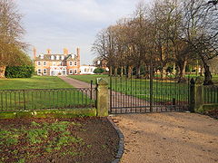
Orgreave Hall
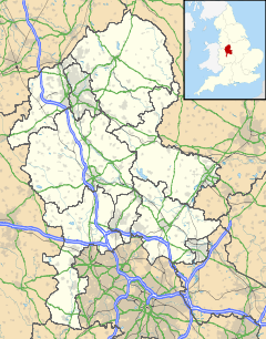
 Orgreave shown within Staffordshire
OS grid reference SK148161 Parish Alrewas District Lichfield Shire county Staffordshire Region West Midlands Country England Sovereign state United Kingdom Post town BURTON-ON-TRENT Postcode district DE13 Dialling code 01283 Police Staffordshire Fire Staffordshire Ambulance West Midlands EU Parliament West Midlands UK Parliament Lichfield [1] List of places: UK • England • Staffordshire Orgreave is a hamlet in the English county of Staffordshire. It lies in the Trent Valley some 61⁄2 miles (10 km) north-east of the city of Lichfield, the A513 road runs to the south of the hamlet.
Historically Orgreave was a township of Alrewas and included the hamlet of Overley[2] which is located between them at grid reference SK160156. Orgreave remains in the civil parish of Alrewas which, in turn, forms part of Lichfield District; until 2009 it was in the parish of Alrewas and Fradley[3].
Orgreave Hall, formerly a seat of the Viscounts Anson, is a residential care home.
References
- ^ "United Kingdom Parliament". http://www.parliament.uk/. Retrieved 18 September 2009.
- ^ "GENUKI". http://www.genuki.org.uk/big/eng/STS/Alrewas/index.html. Retrieved 21 September 2009.
- ^ "Register of Electors 2009: Lichfield District (Parish Order)". http://www.lichfielddc.gov.uk/downloads/EURO_POLLING_STATIONS_1_.pdf. Retrieved 20 September 2009.
External links
- Map sources for Orgreave, Staffordshire
Categories:- Staffordshire geography stubs
- Lichfield
- Hamlets in Staffordshire
Wikimedia Foundation. 2010.

