Lowell Locks and Canals Historic District
- Lowell Locks and Canals Historic District
Infobox_nrhp | name =Lowell Locks and Canals Historic District
nrhp_type = nhld
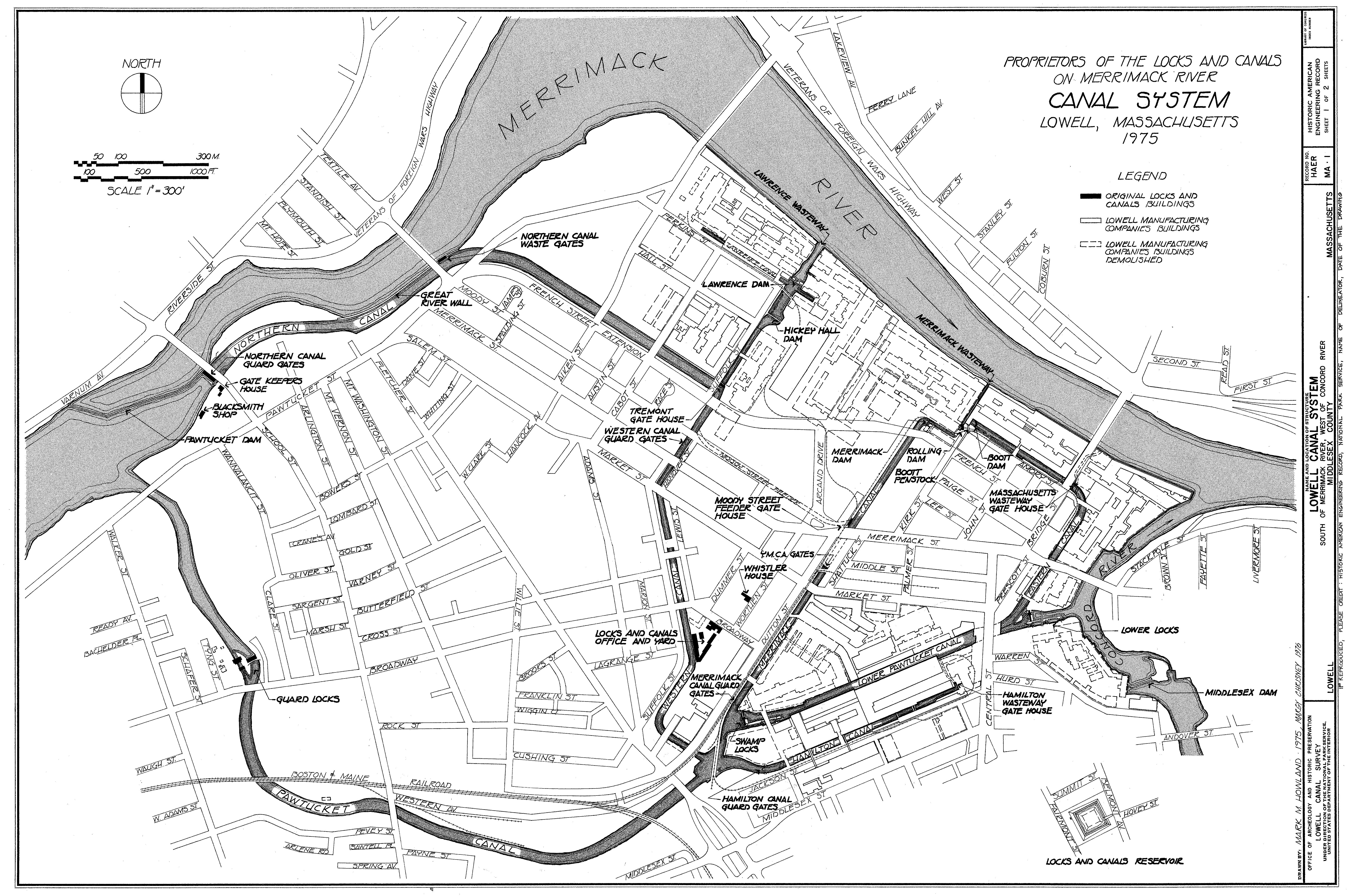
caption = 1975 Map
location= Lowell, Massachusetts
lat_degrees = 42
lat_minutes = 38
lat_seconds = 44
lat_direction = N
long_degrees = 71
long_minutes = 19
long_seconds = 12
long_direction = W
locmapin = Massachusetts
area =
built =1821
architect= Appleton,Nathan; Boott,Kirk
architecture= No Style Listed
designated=December 22, 1977
added = August 13, 1976
governing_body = National Park Service
refnum=76001972[cite web|url=http://www.nr.nps.gov/|title=National Register Information System|date=2008-04-15|work=National Register of Historic Places|publisher=National Park Service] ]
Lowell Locks and Canals Historic District is a National Historic Landmark District between Middlesex Street and the Merrimack River in Lowell, Massachusetts.
The lock and canals were largely built in 1821 by Nathan Appleton and Kirk Boott for early industrial use. The site was added to the National Historic Register in 1976.[cite web|url=http://www.nr.nps.gov/|title=National Register Information System|date=2008-04-15|work=National Register of Historic Places|publisher=National Park Service] [ [http://tps.cr.nps.gov/nhl/detail.cfm?ResourceId=1675&ResourceType=District NPS NHL Listing info] ] ]
References
Wikimedia Foundation.
2010.
Look at other dictionaries:
National Historic Landmark — Historic Landmark auf Pearl Harbor National Historic Landmarks (NHL) sind Stätten in den Vereinigten Staaten, die vom Innenministerium als besonders bedeutend eingestuft wurden, weil sie Ort eines wichtigen Ereignisses der amerikanischen… … Deutsch Wikipedia
National Register of Historic Places listings in Lowell, Massachusetts — Map of all coordinates from Google Map of all coordinates from Bing … Wikipedia
History of Lowell, Massachusetts — Lowell, Massachusetts is considered the Cradle of the American Industrial Revolution, as it was the first large scale factory town in America. Situated along the Merrimack River in northeastern Massachusetts, Lowell was founded to take advantage… … Wikipedia
Lowell National Historical Park — Infobox Protected area name = Lowell National Historical Park iucn category = caption = locator x = 264 locator y = 50 location = Lowell, Massachusetts, USA nearest city = Lowell, Massachusetts lat degrees = 42 lat minutes = 38 lat seconds = 48… … Wikipedia
United States — a republic in the N Western Hemisphere comprising 48 conterminous states, the District of Columbia, and Alaska in North America, and Hawaii in the N Pacific. 267,954,767; conterminous United States, 3,022,387 sq. mi. (7,827,982 sq. km); with… … Universalium
Middlesex Canal — Shawsheen River Aqueduct, Middlesex Canal, Billerica/Wilmington Town Line, Massachusetts … Wikipedia
Lewiston, Maine — Infobox Settlement official name = Lewiston, Maine settlement type = City imagesize = 250x200px image caption = The city of Lewiston to the right, with the twin city of Auburn on the left. The Androscoggin River separates the cities. image… … Wikipedia