- Batac City, Ilocos Norte
Infobox Settlement
official_name = City of Batac
native_name = Ciudad ti Batac
another native_name = Lungsod ng Batac
nickname = Home of Great Leaders,
City of My Dreams
settlement_type =
motto = Aramid Pakakitaan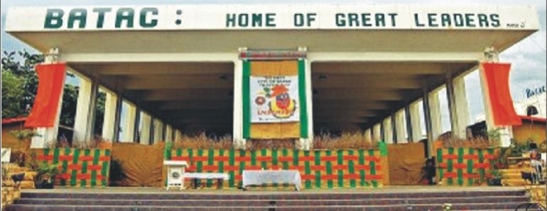
imagesize =
image_caption =
flag_size =
image_
seal_size = 175px
image_shield =
shield_size =
city_logo =
citylogo_size =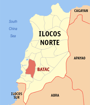
mapsize = 200px
map_caption = Province of Ilocos Norte Map locating the City of Batac
mapsize1 =
map_caption1 =
image_dot_
dot_mapsize =
dot_map_caption =
dot_x = |dot_y =
pushpin_
pushpin_label_position =
pushpin_map_caption =Location in the Philippines
pushpin_mapsize =140
subdivision_type = Country
subdivision_name =Philippines
subdivision_type1 = Region
subdivision_name1 =Ilocos Region
subdivision_type2 = Province
subdivision_name2 =Ilocos Norte
subdivision_type3 =District
subdivision_name3 = 2nd District, Ilocos Norte
subdivision_type4 =Barangay s
subdivision_name4 = 43
government_footnotes =
government_type =
leader_title = Mayor
leader_name = Jeffrey Jubal C. Nalupta (Elect)
leader_title1 = Vice Mayor
leader_name1 = Ronald Allan M. Nalupta (Elect)
leader_title2 =
leader_name2 =
leader_title3 =
leader_name3 =
leader_title4 =
leader_name4 =
established_title = Cityhood
established_date =June 23 ,2007
established_title2 =
established_date2 =
established_title3 =
established_date3 =
established_title3 =
established_date3 =
area_magnitude =
unit_pref =
area_footnotes =
area_total_km2 = 161.01
area_land_km2 =
area_water_km2 =
area_total_sq_mi =
area_land_sq_mi =
area_water_sq_mi =
area_water_percent =
area_urban_km2 =
area_urban_sq_mi =
area_metro_km2 =
area_metro_sq_mi =
population_as_of = August 1, 2007
population_footnotes =
population_note =
population_total = 50,675
population_density_km2 =
population_density_sq_mi =
population_metro =
population_density_metro_km2 =
population_density_metro_sq_mi =
population_urban =
population_density_urban_km2 =
population_density_urban_sq_mi =
population_blank1_title =
population_blank1 =
population_density_blank1_km2 =
population_density_blank1_sq_mi =
timezone = PST
utc_offset = +8
timezone_DST =
utc_offset_DST =
latd = 18 | latm=03| lats= | latNS=N
longd = 120 | longm=34| longs= | longEW=E
elevation_footnotes =
elevation_m =
elevation_ft =
postal_code_type =Postal Code
postal_code = 2906
area_code = 77
blank_name =Languages
blank_info = Ilokano, Tagalog, English
blank1_name =
blank1_info =
website =
footnotes =Batac City is a city in the province of Ilocos Norte,
Philippines . The city is located in the northwest corner of the large island ofLuzon , about 11.2 km from the eastern shore of the South China Sea.According to the
2007 census, it has a population of 50,675.Batac City, known as the "Home of Great Leaders", as it is the home town of many significant figures in the history of the Philippines. Among these is the former Philippine president
Ferdinand Marcos . It is also the birthplace ofGregorio Aglipay , the founder of thePhilippine Independent Church , better known as the Aglipayan Church, and Gen.Artemio Ricarte , the "Father of thePhilippine Army ".Batac City is well-known for being the home of the
Mariano Marcos State University (MMSU), a high-degree granting university that has several branches throughout the province.History
Batac is one of the oldest towns in Ilocos Norte. It was founded by the conqiustador
Juan de Salcedo in 1577, shortly after he had consolidated Spanish rule inVigan ,Ilocos Sur .fix|link=Wikipedia:Contents|text=citation neededIn the early 1867, the first site of the town of Batac was San Josef, now Brgy. Palpalicong. Two separate communities existed at the time. One was a Christian community headed by a chief called Captain Bazar, and the other a non-Christian community called "Itneg", headed by Captain Tagley, at Sitio Nagalisan, now a part of Brgy. Payao.fix|link=Wikipedia:Contents|text=citation needed
As Spain pushed further into the hinterlands, the non-Christian converted and assimilated into the growing Christians community. The united communities grew into the town of Batac.fix|link=Wikipedia:Contents|text=citation needed
In 1998, Municipality of Batac qualified to become a city. Nine years later, Republic Act 9407, the law that converted the Municipality of Batac into a component city in the Province of Ilocos Norte, to be known as the City of Batac, was overwhelmingly ratified by the people in a plebiscite conducted on June 23, 2007.fix|link=Wikipedia:Contents|text=citation needed
Origin of the City's Name
The word "Batac" in a local dialect translates as "pull". More loosely, it refers to "the people's pulling their efforts together."fix|link=Wikipedia:Contents|text=citation needed
Batac has an interesting colloquial origin of its name. According to a legend, set in pre-settlement Batac, a man fell into a deep hole while he was digging for the root crop "camangeg". He struggled to get out but could not despite his best efforts. He cried for help but nobody was around. He waited for hours and had given up hope of being saved. Fortunately, two men from the neighboring town of Paoay happened to pass by. They heard the man shouting and traced it to where he was trapped. Upon seeing him, they heared the man said "Bataquennac! Bataquennac!" The two men did not understand until the man explained that he was saying, "Pull me up! Pull me up!" They did just that. When the two men reached their hometown, they told their story to their friends. Since then, the town has been called "Batac," which is derived from the word "bataquennac."fix|link=Wikipedia:Contents|text=citation needed
Geography
Batac is located in the mid southwestern portion of the province of Ilocos Norte. It lies approximately within altitude 17º17’ north and longitude 120º28’ east. Its boundaries include the Municipality of San Nicolas on the north; Municipality of Sarrat on the northeast; Municipality of Marcos on the east-northeast; Municipality of Banna on the east; Municipality of Pinili on the southeast; Municipality of Currimao on the southwest; and the Municipality of Paoay on the west. It is about 472 kilometers north of Metro Manila, about 18 km. south of
Laoag City , the capital of the province; 275 km. north ofSan Fernando City , the regional center of Ilocos Region and 11.2 km east of the eastern shore of South China Sea.Travel time by motor vehicle at this time is very convenient because of well paved roads and is 15 – 20 minutes to Laoag City and 8 – 9 hours to
Metro Manila .Batac City has a total land area of 16, 101 hectares. The terrain of the city ranges from flat to rolling and hilly and to very steep. The broad valleys are mostly located in poblacions with a slope of 0-8%. All the rural barangays except those in the eastern part have a slope of 0 -30%. There are various soil types that are poorly drained due to the heavy texture of most of the subsoil. There are two rivers that cut across the city of Batac, the Quiaoit River (Pagdanuman) and the Garasgas River.
Batac City lies within the tropical rain forest climate zone (Köppenzone "Af"), and experiences two distinct seasons. From the later part of May to October is the wet season, with an annual average rainfall of 114.07 inches (PAG-ASA, 2000). The dry season lasts from November to April.
Barangays
The City of Batac is politically subdivided into 43
barangay s, 14 of which constitute thepoblacion .External links
* [http://www.cityofbatac.org/ Official website of the City of Batac]
* [http://www.batac.com/ Official Bataqueños Portal]List of Great Leaders on Batac City
*
Gregorio Aglipay
*Ferdinand E. Marcos
*Artemio Ricarte

Wikimedia Foundation. 2010.