- Salvador Benedicto, Negros Occidental
-
Salvador Benedicto — Municipality — 
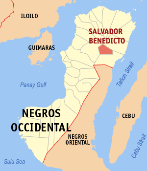
SealMap of Negros Occidental showing the location of Salvador Benedicto. Location in the Philippines
 Salvador Benedicto
Coordinates: 10°33′2″N 123°14′11″E / 10.55056°N 123.23639°ECoordinates: 10°33′2″N 123°14′11″E / 10.55056°N 123.23639°E Country  Philippines
Region Western Visayas Province Negros Occidental District 1st District of Negros Occidental Founded February 9, 1983 Barangays 7 Government – 1st District of Negros Occidental Representative Julio A. Ledesma, IV – Mayor Lawrence Marxlen J. Dela Cruz – Vice Mayor Cynthia J. Dela Cruz Area – Total 170.56 km2 (65.9 sq mi) Population (2000) – Total 17,259 – Density 101.2/km2 (262.1/sq mi) Time zone PST (UTC+8) ZIP code Income class 4th class; partially urban Website elgu.ncc.gov.ph Salvador Benedicto (also known as Don Salvador Benedicto) is a 4th class municipality in the province of Negros Occidental, Philippines. According to the 2000 census, it has a population of 17,259 people in 3,456 households.
The municipality is also dubbed as "The Summer Capital of Negros Occidental".
Barangays
Salvador Benedicto is politically subdivided into 7 barangays.
- Bago (Lalung)
- Bagong Silang (Marcelo)
- Bunga
- Igmaya-an
- Kumaliskis
- Pandanon
- Pinowayan (Prosperidad)
External links
Municipalities Component cities - Bago
- Cadiz
- Escalante
- Himamaylan
- Kabankalan
- La Carlota
- Sagay
- San Carlos
- Silay
- Sipalay
- Talisay
- Victorias
Highly urbanized city (Administratively independent from the province, but grouped under Negros Occidental by the National Statistics Office)Categories:- Municipalities of Negros Occidental

Wikimedia Foundation. 2010.