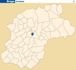
- Cividade
-
Cividade — Parish — Location in the municipality of Braga Country Portugal Municipality Braga Area – Total 0.28 km2 (0.1 sq mi) Population – Total 1,884 – Density 6,728.6/km2 (17,426.9/sq mi) Cividade is a Portuguese parish, located in the municipality of Braga. It has a population of 1 884 inhabitants and a total area of 0.28 km².
Adaúfe • Arcos • Arentim • Aveleda • Cabreiros • Celeirós • Cividade • Crespos • Cunha • Dume • Escudeiros • Espinho • Esporões • Ferreiros • Figueiredo • Fradelos • Fraião • Frossos • Gondizalves • Gualtar • Guisande • Lamaçães • Lamas • Lomar • Maximinos • Mire de Tibães • Morreira • Navarra • Nogueira • Nogueiró • Padim da Graça • Palmeira • Panóias • Parada de Tibães • Pedralva • Pousada • Priscos • Real • Ruilhe • Santa Lucrécia de Algeriz • Santo Estêvão do Penso • São João do Souto • São José de São Lázaro • São Julião dos Passos • São Mamede de Este • Merelim São Paio • São Pedro de Este • São Pedro de Merelim • São Pedro de Oliveira • São Vicente • São Vicente do Penso • São Vítor • Sé • Semelhe • Sequeira • Sobreposta • Tadim • Tebosa • Tenões • Trandeiras • Vilaça • Vimieiro
Coordinates: 41°32′46″N 8°25′05″W / 41.546°N 8.418°W
Categories:- Parishes of Braga
- Braga geography stubs
Wikimedia Foundation. 2010.

