- Hurricane Lester (1998)
Infobox Hurricane
Name=Hurricane Lester
Type=Hurricane
Year=1998
Basin=EPac
Image location=Hurricane Lester (1998) GOES.jpg
Puerto Angel, Oaxaca
Formed=October 15, 1998
Dissipated=October 26, 1998
1-min winds=100
Pressure=965
Da
Fatalities=2
Areas=Mexico
Hurricane season=1998 Pacific hurricane season Hurricane Lester was the 15th
tropical cyclone , 12th named storm and eighth hurricane of the1998 Pacific hurricane season . Lester originated from atropical wave that emerged off the coast ofAfrica on September 29. Under favorable conditions, the storm was classified as a tropical depression on October 15. The depression was upgraded to a tropical storm later that day and a hurricane on October 16. After undergoing fluctuations in intensity, Lester reached peak winds of convert|115|mph|km/h|abbr=on|lk=on, a Category 3 hurricane on theSaffir-Simpson Hurricane Scale . After several days, it degenerated into a tropical storm on October 26, and dissipated shortly after. The hurricane made its closest approach to land on October 18, producing moderate winds and heavy rainfall. Amudslide triggered by the precipitation killed two children, although damage is unknown.Meteorological history
A
tropical wave moved off the coast ofAfrica on September 29, 1998 and on October 5, an area of convection along the wave developed into Atlantic Hurricane Lisa. The wave axis continued westward, and after crossingCentral America a low-level circulation developed on October 13, about 170 miles (275 km) south of the border betweenEl Salvador andGuatemala . The system drifted northwestward, and as convection increased around the center a banding featured began to develop. At 0000 UTC on October 15, theNational Hurricane Center designated it as Tropical Depression Fourteen-E.cite web|author=Miles B. Lawrence|year=1998|title=Hurricane Lester Preliminary Report|publisher=National Hurricane Center|accessdate=2007-02-11|url=http://www.nhc.noaa.gov/1998lester.html] The depression contained a large envelope of convective activity, and under favorable conditions including warm water, low vertical wind shear and good outflow, it gradually began to intensify. [cite web|author=Guiney|title=Tropical Depression Fourteen-E Dicussion Number 1|year=1998|publisher=National Hurricane Center|accessdate=2008-04-28|url=http://www.nhc.noaa.gov/archive/dis/NEP1498.001] Initially, the exact direction of forward movement was somewhat uncertain, although a northwestward track was predicted. [cite web|author=Pasch|title=Tropical Depression Fourteen-E Discussion Number 2|year=1998|publisher=National Hurricane Center|accessdate=2008-04-28|url=http://www.nhc.noaa.gov/archive/dis/NEP1498.002] On the morning of October 15, visible satellite imagery suggested that the center of circulation was located northeast of the previous estimates. [Cite web|author=Rappaport|title=Tropical Depression Fourteen-E Dicussion Number 3|year=1998|publisher=National Hurricane Center|accessdate=2008-04-28|url=http://www.nhc.noaa.gov/archive/dis/NEP1498.003] Thunderstorm activity organized close to the center by 1400 UTC, [Cite web|author=Rappaport|title=Tropical Depression Fourteen-E Discussion Number 4|year=1998|publisher=National Hurricane Center|accessdate=2008-04-28|url=http://www.nhc.noaa.gov/archive/dis/NEP1498.004] and by 1800 UTC the depression was upgraded to Tropical Storm Lester.Shortly thereafter, the storm took a slight jog to the west, [Cite web|author=Guiney|title=Tropical Storm Lester Discussion Number 5|year=1998|publisher=National Hurricane Center|accessdate=2008-04-28|url=http://www.nhc.noaa.gov/archive/dis/NEP1498.005] and at the same time outflow became restricted to the southwest of the circulation. [Cite web|author=Avila|title=Tropical Storm Lester Discussion Number 6|year=1998|publisher=National Hurricane Center|accessdate=2008-04-28|url=http://www.nhc.noaa.gov/archive/dis/NEP1498.006] At 1400 UTC on October 16, data from a Reconnaissance Aircraft confirmed that the storm had attained hurricane intensity with a minimum central pressure of 992 mb. [Cite web|author=Rappaport|title=Hurricane Lester Discussion Number 8|year=1998|publisher=National Hurricane Center|accessdate=2008-04-28|url=http://www.nhc.noaa.gov/archive/dis/NEP1498.008] The first signs of an eye began to appear embedded within a ring of deep convection by early on October 17, while moving west-northwest at about convert|6|mph|km/h|abbr=on. [Cite web|author=Avila|title=Hurricane Lester Discussion Number 10|year=1998|publisher=National Hurricane Center|accessdate=2008-04-29|url=http://www.nhc.noaa.gov/archive/dis/NEP1498.010] Shortly after, the hurricane became nearly stationary due to a shortwave which passed north of the system, shortly before reaching Category 2 status on the Saffir-Simpson Hurricane Scale. [Cite web|author=Rappaport|title=Hurricane Lester Discussion Number 11|year=1998|publisher=National Hurricane Center|accessdate=2008-04-29|url=http://www.nhc.noaa.gov/archive/dis/NEP1498.011] Early on October 18, the eye began to wobble slightly and the ring of cold cloud tops were showing signs of disorganization, slowing further intensification for several hours. [cite web|author=Pasch|title=Hurricane Lester Discussion Number 14|year=1998|publisher=National Hurricane Center|accessdate=2008-04-29|url=http://www.nhc.noaa.gov/archive/dis/NEP1498.014] At 1400 UTC, Lester's winds increased to convert|100|mph|km/h|abbr=on and the storm made its closest approach to land on October 18, about 70 miles (110 km) south of
Puerto Angel, Oaxaca . Later that day, it weakened to Category 1 status, [cite web|author=Pasch|title=Hurricane Lester Discussion Number 18|year=1998|publisher=National Hurricane Center|accessdate=2008-04-29|url=http://www.nhc.noaa.gov/archive/dis/NEP1498.018] although quickly re-intensified. [cite web|author=Guiney|title=Hurricane Lester Discussion Number 19|year=1998|publisher=National Hurricane Center|accessdate=2008-04-29|url=http://www.nhc.noaa.gov/archive/dis/NEP1498.019] Verticalwind shear associated with a mid-to-upper-level low pressure system developed and began to affect the storm's circulation on October 19, thus weakening it slightly. [cite web|author=Guiney|title=Hurricane Lester Discussion Number 20|year=1998|publisher=National Hurricane Center|accessdate=2008-04-29|url=http://www.nhc.noaa.gov/archive/dis/NEP1498.020] However, early on October 20 the hurricane regained organization and once again intensified. Lester strengthened to reach a peak intensity of 115 mph (185 km/h) on October 22, about 355 miles (570 km) southwest ofManzanillo, Colima . Coinciding with its peak intensity, a short-wave trough caused Lester to stall before turning to the southwest and weakening. At 0200 UTC on October 23 Lester rapidly lost deep convection, and weakened to Category 1 status. Later that morning, the storm was downgraded to a tropical storm while tracking southwest. [Cite web|author=Avila|title=Tropical Storm Lester Discussion Number 35|year=1998|publisher=National Hurricane Center|accessdate=2008-04-29|url=http://www.nhc.noaa.gov/archive/dis/NEP1498.035] By October 24, the low-level center of circulation became exposed from the cloud structure, [Cite web|author=Jarivnen|title=Tropical Storm Lester Discussion Number 41|year=1998|publisher=National Hurricane Center|accessdate=2008-04-29|url=http://www.nhc.noaa.gov/archive/dis/NEP1498.041] and at 0000 UTC on October 16, Lester had degenerated into a tropical depression, about 500 miles (805 km) southwest of the southern tip ofBaja California Peninsula , shortly before dissipating.Preparations and impact
[
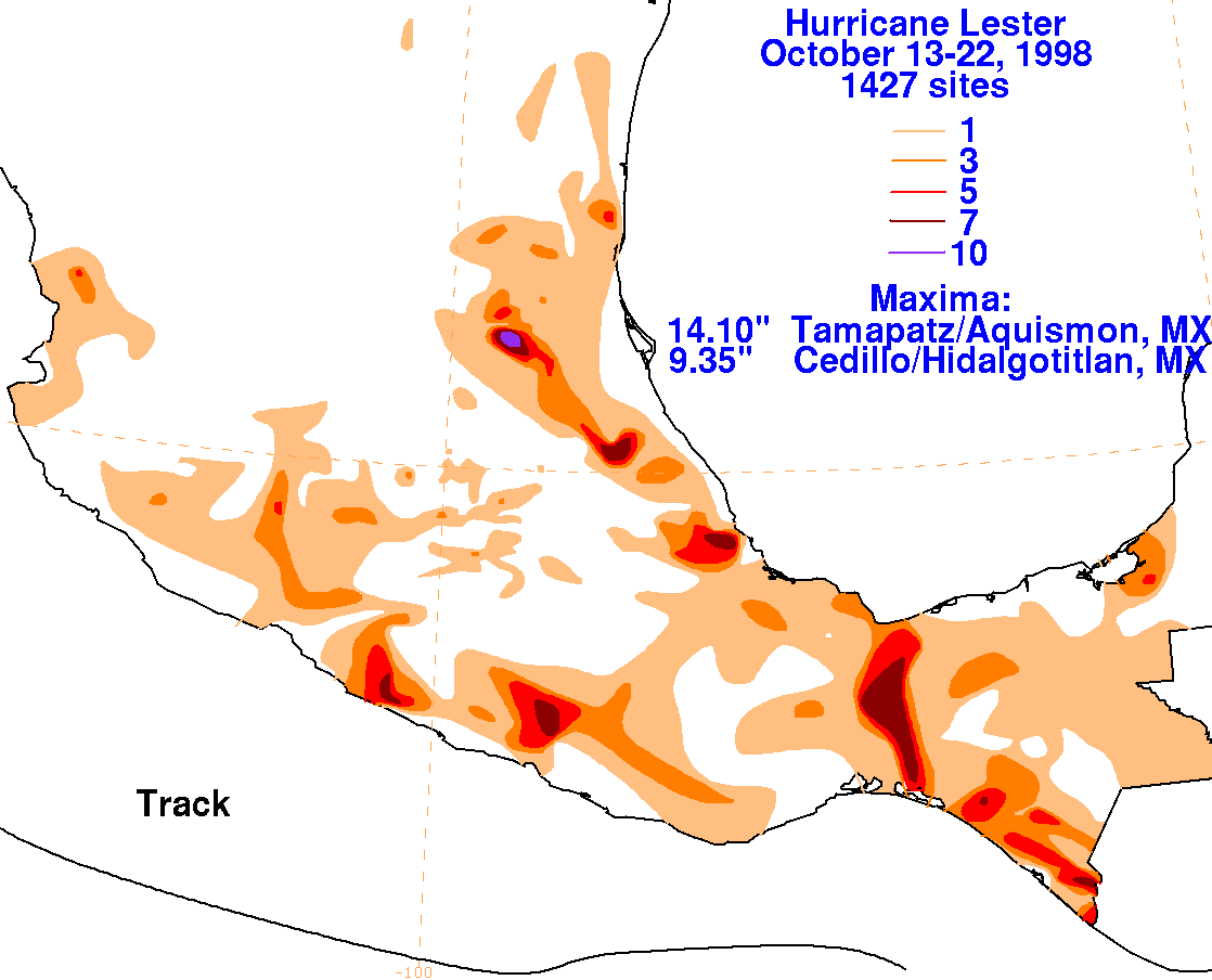
right|210px|thumb|Rainfall_totals_provided_by_the_Hydrometeorological Prediction Center ] In anticipation of the storm, the government ofMexico issued a hurricane warning from Puerto Arista to Punta Maldonaldo and later fromSalina Cruz toAcapulco . A tropical storm warning was also issued fromSipacate , Guatemala to Puerto Arista, Mexico. The threat of the hurricane prompted officials to order the evacuation of 3,000 people along the southern coast of Mexico to 500 emergency shelters.cite news|author=Associated Press|date=1998-10-18|title=Thousands flee Mexico coast as Hurricane Lester nears|accessdate=2007-02-11]The storm dropped heavy rainfall across southwestern
Guatemala . Up to 9 inches (228 mm) of rainfall was reported in localized areas along the Pacific coast of the country. Moisture brought around the northeast periphery of theSierra Madre Occidental led to a narrow band of heavy rainfall along the upslope side of the mountain range, with a local precipitation maximum exceeding 14 inches (360 mm). [Hydrometeorological Prediction Center (2007). [http://www.hpc.ncep.noaa.gov/tropical/rain/lester1998.html Hurricane Lester.] Retrieved on2007-02-12 .] It is reported that tropical-storm-force winds occurred along coastal areas of southern Mexico. The rainfall destroyed some houses and killed numerous livestock, and triggered a mudslide which killed two children.cite news|author=Calgary Herald|date=1998-10-17|title=Weather Kills Two in Guatemala|accessdate=2007-02-11] [cite news|author=Associated Press|title=Hurricane kills two, heads for Mexican coast leaves flooding in Guatemala|year=1998|publisher="San Jose Mercury News"|accessdate=2008-05-05] [Cite news|author=Accosiated Press|title=Storm kills two in Guatemala, roars toward southern Mexico|year=1998|publisher="Fort Worth Star-Telegram"|accessdate=2008-05-05] InHonduras , rainfall from the Lester destroyed a bridge which affected transportation for about 1,000 people.cite news|author=Xinhua News Agency|date=1998-10-17|title=Heavy Rains Bring Bridge Down in Honduras|accessdate=2007-02-11] Heavy rainfall was reported inChiapas , causing moderate river flooding though no reported damage.ee also
*Other tropical cyclones name Lester
*List of Pacific hurricanes References
External links
* [http://www.nhc.noaa.gov/1998lester.html National Hurricane Center's Tropical Cyclone Report]
_south_of_)
Wikimedia Foundation. 2010.