- Yelpin
-
Yelpin
ԵլփինView from the highway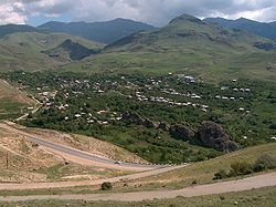
 Yelpin
ԵլփինCoordinates: 39°48′21″N 45°06′37″E / 39.80583°N 45.11028°E Country Armenia Marz (Province) Vayots Dzor Established 1828 Population (2008) – Total 1,418 Time zone (UTC+4) – Summer (DST) (UTC+5) Coordinates: 39°48′21″N 45°06′37″E / 39.80583°N 45.11028°E Yelpin (
 /jɛlˈpiːn/; Armenian: Ելփին; also Romanized as Yelp’in and Elpin) is a village community located in the South-West of Armenia in Vayots Dzor province (marz). It is located 97 km away from Yerevan and 27 km away from provincial center Yeghegnadzor. It borders with Autonomous Republic of Nakhijevan (Azerbaijan) in South, with lands of Zangakatun community (Ararat province) in West, with Chivagyugh community (Vayots Dzor province) in South-West. Community lands stretch from 1400 to 2800m, whereas the settlement itself is located at 1545m above the sea level. Number of households -378, houses- 273, families- 200 (as of 2007). Main occupations of the community members are gardening, land cultivation, animal husbandry, poultry farming and bee-keeping.
Contents
History
Yelpin community was established in 1828, after Russo-Persian War (1826-1828). The founders (ethnic Armenians) fled from Persian regions of Khoy and Salmast. The community was founded in the place of Nrbuyn village, and inherited its name, which gradually transformed- Nrbuyn, Nrbin, Irpin and finally Yelpin. Famous Armenian historian Stepanos Orbelian, in his book Patmutyun Sisakan, (History of Sis) mentions Adopen, Khndzorut, Kechut, Chochanak, Chavadzor, Mokhrot and other historical places to be located in the administrative territory of Yelpin. However, the territory of Yelpin was inhabited since the Stone Age, evidence of which can be found in numerous caves in the vicinity. The Bronze Age is the best represented and archaeological expeditions are very active in the area. Here were found numerous artifacts, such as stone and metal instruments, arms, pottery and many others, which are kept in the Yeghegnadzor ethnographic museum.
Culture
 New church built in 2005
The community is surrounded by monasteries and structures having cultural value. To the North-West from the village, remnants of medieval fortress can be found, 10 km away there are numerous ancient decorated gravestones. Following the old way to Aghavnadzor, remnants of Geshin settlement can be found, which has a famous cave in the nearby․ To the South-East of the village, there is a 14th century sanctuary of Toukh Manuk and medieval Didivan monastery in Gndasar, preserved from the times of Bagratuni dynasty. Not far away from the community there is a Noravank monastic complex (XII c), which is also a UNESCO heritage site. In 2005 a new church was built in the village center.
Nature
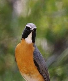
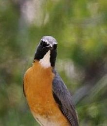 Irania gutturalis
Flora
The flora of the area is quite rich. The vicinities of Yelpin have always been known for their abundance of alpine herbs and officinal plants. In the ancient times there was an alpine settlement of seyids (medicine people), who practiced phytotherapy and traditional medicine. The most common used were mentha, rosa canina, Armenian ginseng and many others. There are numerous endemic and endangered plants registered in the national Red Book, such as Pragnos lophoptera, Seseli leptocladium (endemic), Cephalorrinhus Kirpicznikovii, Hieracium pannosum, Steptorhamphus Czerepanovii, Acanthophyllum pungens, Astragalus karakuschensis, Vicia cappadocica, Hipericum formosissimum, Crocus speciosus. Gladiolus atroviolaceus, Iris caucasicus, Iris pseudocaucasica, Juglans regia, Salvia grossheimii, Allium akkaka, Asphodeline dendroides, Secale Vavilovii, Triticum boeoticum.
Fauna
The vicinities of the Yelpin community are known for its fauna, especially birds. The Red Book animals and birds are the following: Ursus arctos syriacus, Capra aegarus aegarus, Accipiter brevipes, Ciraetus gallicus gallicus, Lanius senator niloticus, Silvia hortensis crassirostris, Luscinia svecica accidentalis, Irania gutturalis, Sitta tephronota obscura, Tichodroma muraria, Carposiza brachidactyla, Eumeces schnederi, Mabuya aurata, Vipera raddei.
Geography
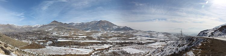
Panorama of Yelpin in winter References
- REC Caucasus. 2008. Sustainable Development of Mountain Communities in the Caucasus. Local Agenda 21. Report.
- Yelpin at GEOnet Names Server
- World Gazeteer: Armenia – World-Gazetteer.com
- Report of the results of the 2001 Armenian Census, National Statistical Service of the Republic of Armenia
Related links
Capital: YeghegnadzorVayk 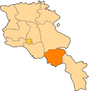
Jermuk Yeghegnadzor Agarakadzor · Aghavnadzor · Aghnjadzor · Areni · Arpi · Artabuynk · Chiva · Getap · Gladzor · Gnishik · Goghtanik · Hermon · Horbategh · Hors · Karaglukh · Khachik · Malishka · Rind · Salli · Shatin · Taratumb · Vardahovit · Vernashen · Yeghegis · Yeghegnadzor · YelpinCategories:- Populated places in Vayots Dzor
- Populated places established in 1828


Wikimedia Foundation. 2010.