- Copdock
-
Coordinates: 52°01′50″N 1°04′54″E / 52.030687°N 1.081595°E
Copdock 
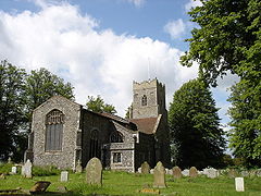
St. Peter's, Copdock
 Copdock shown within Suffolk
OS grid reference TM1141 Shire county Suffolk Region East Country England Sovereign state United Kingdom Post town IPSWICH Postcode district IP8 Police Suffolk Fire Suffolk Ambulance East of England EU Parliament East of England List of places: UK • England • Suffolk Copdock is a small settlement in Suffolk, England. It is 4.8 kilometres (3 mi) southwest of Ipswich. It is located on the former A12 road (now designated C475) which was blocked off at White's Corner after the construction of the Copdock Interchange and the A14 road Ipswich bypass.
The local authority for the area is Babergh District Council.
The village has joined up with the neighbouring village of Washbrook to form the Copdock & Washbrook Parish Council.
It has a local primary school called Copdock Primary School[1].
The local church is called St. Peter's Copdock and is C of E.
The local village hall is located on the old A12. It was built in 1991 and is available to take bookings for functions. It has ample parking, and is situated within the grounds of the local playing fields.
Various sports clubs use the venues playing fields and is home to a thriving cricket team, Copdock & Old Ipswichian CC - [2]
Places to stay in Copdock include the Copdock Elizabeth Hotel which is located opposite the village hall.
External links
[3] - Copdock Primary School [4] - Official Village Web Site
Categories:- Villages in Suffolk
- Suffolk geography stubs
Wikimedia Foundation. 2010.

