- Chiriaco Summit Airport
-
Chiriaco Summit Airport 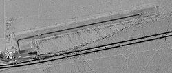
USGS aerial image, 4 June 2002 IATA: none – ICAO: none – FAA LID: L77 Summary Airport type Public Owner County of Riverside Serves Chiriaco Summit, California Elevation AMSL 1,713 ft / 522 m Coordinates 33°39′54″N 115°42′36″W / 33.665°N 115.71°W Runways Direction Length Surface ft m 6/24 4,600 1,402 Asphalt Statistics (2006) Aircraft operations 6,000 Source: Federal Aviation Administration[1] Chiriaco Summit Airport (FAA LID: L77) is a county-owned public-use airport located one nautical mile (1.85 km) northeast of the central business district of Chiriaco Summit, in Riverside County, California, United States.[1]
The airport is maintained as a functioning airport for emergency purposes and recreational VFR use by the Riverside County government. Some west coast aero clubs use the airport (and nearby restaurant) as a "destination" site for annual week-end competitions.
Contents
History
The airport was opened in April 1943 as Shavers Summit Army Airfield and was used by the United States Army Air Forces Fourth Air Force as a training base during World War II. At the end of the war the airfield was determined to be excess by the military and turned over to the local government for civil use.[2]
Facilities and aircraft
Chiriaco Summit Airport covers an area of 570 acres (230 ha) at an elevation of 1,713 feet (522 m) above mean sea level. It has one runway designated 6/24 with an asphalt surface measuring 4,600 by 50 feet (1,402 x 15 m). For the 12-month period ending November 30, 2006, the airport had 6,000 general aviation aircraft operations, an average of 16 per day.[1]
See also
References
- ^ a b c FAA Airport Master Record for L77 (Form 5010 PDF). Federal Aviation Administration. Effective 3 June 2010.
- ^ Thole, Lou (1999), Forgotten Fields of America : World War II Bases and Training, Then and Now - Vol. 2. Publisher: Pictorial Histories Pub, ISBN 1575100517
External links
- George S. Patton Memorial Museum and Chiriaco Summit, CA Airport
- Resources for this airport:
- AirNav airport information for L77
- FlightAware airport information and live flight tracker
- SkyVector aeronautical chart for L77
Categories:- Airfields of the United States Army Air Forces in California
- Airports in Riverside County, California

Wikimedia Foundation. 2010.