Morgantown Lock and Dam

Morgantown Lock and Dam
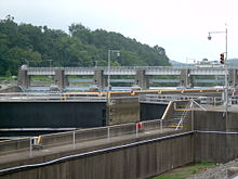
Location Morgantown, West Virginia
Coordinates 39°37′10″N 79°58′03″W / 39.61944°N 79.9675°W / 39.61944; -79.9675Coordinates: 39°37′10″N 79°58′03″W / 39.61944°N 79.9675°W / 39.61944; -79.9675
Construction began 1948
Opening date 1950

Morgantown Lock and Dam is a navigational lock and gated dam on the Monongahela River at Morgantown, West Virginia. It is part of a series of dams that canalizes the Monongahela to a depth of at least 9 feet (2.7 m) for its entire length from Fairmont, West Virginia to Pittsburgh, Pennsylvania. It is maintained by the U.S. Army Corps of Engineers, Pittsburgh District.

Morgantown has a single lock chamber located on the left-descending river bank. The dam's upper pool extends 6.0 miles (9.7 km) upstream to Hildebrand Lock and Dam, with its 11.2-mile (18.0 km) downstream pool being formed by Point Marion Lock and Dam.

Contents

History

Construction on Morgantown Lock and Dam began in 1948 and was completed in 1950.[1]. It replaced old Locks 10 and 11, timber crib structures installed in 1897-1903.

See also

References

External links


Wikimedia Foundation. 2010.

Игры ⚽ Поможем решить контрольную работу

Look at other dictionaries:

  • Hildebrand Lock and Dam — Infobox Dam dam name= Hildebrand Lock and Dam caption= official name= crosses= reservoir= locale= Hilderbrand, West Virginia maint= U.S. Army Corps of Engineers, Pittsburgh District length= height= width= began= 1950 open= 1960 closed= cost=… …   Wikipedia

  • Morgantown, West Virginia — For other uses of Morgantown , see Morgantown. City of Morgantown, West Virginia   City   Downtown Morgantown from North High Street …   Wikipedia

  • List of dams and reservoirs in the United States — This list is incomplete; you can help by expanding it. The following is a partial list of dams and reservoirs in the United States. There are an estimated 75,000 dams in the United States, impounding 600,000 mi (970,000 km) of river or about 17%… …   Wikipedia

  • List of reservoirs and dams in the United States — There are an estimated 75,000 dams in the United States, blocking 600,000 miles (960,000 km) of river or about 17% of rivers in the nation . [cite web|url=http://www.pcffa.org/dams.htm |title=Dams and salmon |accessdate=2008 02 11] The following… …   Wikipedia

  • Chesapeake and Ohio Canal — Map of the path of the C O Canal. The Chesapeake and Ohio Canal, abbreviated as the C O Canal, and occasionally referred to as the Grand Old Ditch, [ …   Wikipedia

  • Transportation in West Virginia — Transportation in West VirginiaRoadsInterstate highwaysU.S. HighwaysWest Virginia State HighwaysAirports*Beckley Raleigh County Memorial Airport *Eastern West Virginia Regional Airport *Elkins Randolph County Airport *Greater Cumberland Regional… …   Wikipedia

  • Butler County, Kentucky — Infobox U.S. County county = Butler County state = Kentucky founded year = 1810 founded date = seat wl = Morgantown area total sq mi = 432 area total km2 = 1118 area land sq mi = 428 area land km2 = 1109 area water sq mi = 3 area water km2 = 9… …   Wikipedia

  • Star City Bridge — Infobox Bridge bridge name= Star City Bridge caption= Viewing the Star City Bridge from upstream in March 2008. official name= Edith Barill Bridge also known as= carries= 5 lanes (4 through plus 1 turn) crosses= Monongahela River locale= Star… …   Wikipedia

  • West Virginia Waterways — finds its source at the highland watersheds of the Allegheny Mountains. These watersheds supply drainage to the creeks often passing through deep and narrow hollows. From the hollows, rushing highland streams collect in bottom land brooks and… …   Wikipedia

  • Louisville, Kentucky — Louisville redirects here. For other uses, see Louisville (disambiguation). Louisville   Consolidated city county   Louisville Jefferson County Metro Government …   Wikipedia

Share the article and excerpts

Direct link
Do a right-click on the link above
and select “Copy Link”