- Okahandja
-
Okahandja 
SealMotto: Semper Prorsum Location in Namibia
 Okahandja
Coordinates: 21°59′S 16°55′E / 21.983°S 16.917°E Country  Namibia
Region Otjozondjupa Region Population (2001)[1] - Total 14,039 Time zone South African Standard Time (UTC+1) Okahandja is a town of 14,000 inhabitants in Otjozondjupa Region, central Namibia, and the district capital of the Okahandja electoral constituency. It is known as the Garden Town of Namibia. It is located 70km north of Windhoek on the B1 road. It was founded around 1800, by two local groups, the Herero and the Nama.[2]
Contents
History
Okahandja means the place where two rivers flow into each other to form one wide one in Otjiherero.[2]
A German pastor, Heinrich Schmelen, became the first European to visit the town in 1827.[3] In 1844, two missionaries were permanently assigned to the town, and a church dates from this period. A military post was established in Okahandja in 1894, and it is this date that is officially recognized as the town's founding.[4]
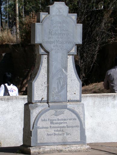
Maharero and his sons, Jan Jonker Afrikaner, Hosea Kutako and Clemens Kapuuo are buried in the town.
Economy
The National Institute for Educational Development (NIED) is today situated in Okahandja. NIED was created after independence as the institute from where a new national system of education was created, replacing the previous racist system of apartheid.
Von Bach Dam is situated outside of Okahandja. It provides most the water for Windhoek.
An open-air curio market attracts tourists, and the town serves as the administrative centre for the Herero people.
Transport
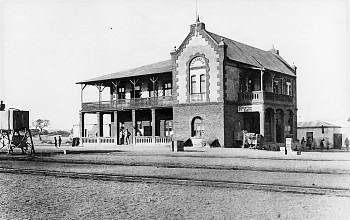
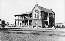 Okahandja train station, 1903
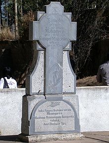 Monument to Maherero in Okahandja
A station on the Trans-Namib Railway was built in 1909, which led to further growth and development in the area.
Education
In the 1870s Rhenish missionaries established the first school. The Augustineum School was reopened at Okahandja on 9 November 1905; it was later moved to Windhoek. Today[update] Okahandja has six primary schools and two high schools. Namwater Vocational, situated outside the main town, is the only institute of higher education in Okahandja.
Politics
Local authority results, 2010
In the 2010 local authority election in Okahandja, SWAPO won with approximately 62% of the vote. Of the five other parties seeking votes in the election, RDP received approximately 13% of the vote, followed by the UDF (8%), the UPM (7%), NUDO (6%) and DTA (2%).[5]
Sport
In the 1970s, Okahandja Soccer Club had a competitive football team that won several competitions.[6]
See also
References
- ^ Republic of Namibia 2001 Population and Housing Census (Basic Analysis with Highlights ed.). Windhoek: Central Bureau of Statistics, National Planning Commission. July 2003. p. 21. ISBN 0869766147.
- ^ a b "Okahandja, a town in Namibia". The Cardbord Box. http://www.namibian.org/travel/namibia/okahandja.html. Retrieved 25 October 2010.
- ^ Dierks, Klaus. "Biographies of Namibian Personalities, R-Z". http://www.klausdierks.com/Biographies/Biographies_3.htm. Retrieved 27 March 2011.
- ^ History of Okahandja Okahandja.net
- ^ Local Authority Election Results for Okahandja
- ^ Kambaekwa, Carlos (20 August 2010). "Alcino ‘Shorty’ da Costa - The Portuguese dynamo". New Era. http://www.newera.com/article.php?artcileid=12581.
Coordinates: 21°59′S 16°55′E / 21.983°S 16.917°E
Categories:- Otjozondjupa Region
- Otjiherero words and phrases
- Okahandja
- Cities in Namibia
- Namibia geography stubs


Wikimedia Foundation. 2010.