- Lages
Infobox City
official_name = Lages
native_name =
nickname = "Princesa da Serra" (Princess of the Serra)
motto =
imagesize =
image_caption = View of the Catedral Diocesana
image_
mapsize =
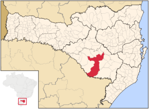
map_caption = Location in the state of Santa Catarina andBrazil
subdivision_type = Country
subdivision_name =Brazil
subdivision_type1 = Region
subdivision_name1 = South
subdivision_type2 = State
subdivision_name2 = Santa Catarina
leader_title =Mayor
leader_name = Renato Nunes de Oliveira
established_title = Founded
established_date =November 22 1776
area_magnitude =
area_total_km2 = 2.644.313
area_total_sq_mi =
area_land_km2 =
area_land_sq_mi =
area_water_km2 =
area_water_sq_mi =
area_water_percent =
area_urban_km2 =
area_urban_sq_mi =
area_metro_km2 =
area_metro_sq_mi =
population_as_of = 2006
population_note =
population_total = 159,604
population_footnotes = [http://www.ibge.gov.br/home/estatistica/populacao/estimativa2006/POP_2006_DOU.pdf]
population_density_km2 = 63.7
population_density_sq_mi =
population_metro =
population_density_metro_km2 =
population_density_metro_sq_mi =
population_urban =
timezone =UTC-3
utc_offset = -3
timezone_DST =UTC-2
utc_offset_DST = -2
latd= 27|latm= 48|lats= 57|latNS=S
longd= 50|longm= 19|longs= 33|longEW=W
elevation_m = 916
elevation_ft =
postal_code_type =
postal_code =
website = [http://www.lages.sc.gov.br/ Lages City Hall]
footnotes =Lages, formerly Lajens, is a
Brazil iantown located in the central part of the state of Santa Catarina, in the region known in Portuguese as "Planalto Serrano".It is located in the
mountain region of the state. It is the maincity of this region, and borders the towns ofOtacílio Costa ,São Joaquim , andCorreia Pinto . The main course of urban water isCarahá River .Lages hosts an annual festival called "
Festa do Pinhão ", that is famous throughout the country.Economically, the city is known for its strong cattle breeding and wood processing factories.
History
In the beginning of the 17th century, the arrival of the first Europeans established the town. The growing of the "
Campos de Lajens " was due to the opening of roads to reach the fields of the stateRio Grande do Sul . The people ofSão Paulo andMinas Gerais were attracted to this region due to the cattle-breeding business with the "gauchos ".Very primitive documents mention Lajens as a stop for horse riders that were traveling from
Sorocaba orSão Paulo , transporting mules, horses and cattle.Correia Pinto , the founder, was a horse rider, and ran cattle groups from Lajens toSão Paulo .On
November 22 ,1766 , Lajens was promoted to state from village. In 1820 it detached itself fromSão Paulo to be part of the state of Santa Catarina. OnMay 25 ,1860 , it was elevated to city status. In 1960 the city's name was changed toLages with a "g" wrongly inserted.Gallery
References
External links
* [http://www.lages.sc.gov.br/ Lages City Hall]
* [http://www.festadopinhao.com Festa do Pinhão official site]


Wikimedia Foundation. 2010.