- Otley railway station
-
Otley Location Place Otley Area City of Leeds Coordinates 53°54′04″N 1°41′29″W / 53.90099°N 1.69138°WCoordinates: 53°54′04″N 1°41′29″W / 53.90099°N 1.69138°W Grid reference SE203450 Operations Pre-grouping North Eastern Railway and Midland Railway (joint) History 1865 Opened 1965 Closed Disused railway stations in the United Kingdom Closed railway stations in Britain
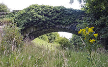
A B C D–F G H–J K–L M–O P–R S T–V W–Z An abandoned stone bridge spans the former track bed.
Otley railway station was a railway station serving the town of Otley in West Yorkshire, England. It was opened as a joint venture on the Otley and Ilkley Joint Railway, constructed by the North Eastern Railway and the Midland Railway, on 1 February 1865. The station was closed on 22 March 1965. The Otley branch line joined Arthington, in the east, to Ilkley and Menston in the west via a junction known as Milnerwood. The length of the line was about six miles[1] and spanned a range of terrain at the foot of The Chevin with a substantial cutting through a sandstone ridge near Milnerwood which can still be seen today by walking the footpath along the old track bed.[2]
Preceding station Disused railways Following station Pool-in-Wharfedale Midland Railway Burley-in-Wharfedale
or MenstonReferences
- ^ "The Midland railway, its rise and progress, a narrative of modern enterprise". Frederick Williams, 1888. http://www.archive.org/stream/midlandrailwayit00willuoft/midlandrailwayit00willuoft_djvu.txt. Retrieved 2009-09-05.
- ^ "Remains of Otley Railway". 2009 photograph by T.J. Blackwell & 1888 source quote. http://www.flickr.com/photos/tjblackwell/3444585467/. Retrieved 2009-09-05.
External links
- Information and pictures about Otley Station
- Otley station on navigable 1947 O. S. map
- Railway junction diagram showing the Otley branch line in 1914
Categories:- Disused railway stations in Leeds
- Former Otley and Ilkley Joint Railway stations
- Railway stations opened in 1865
- Railway stations closed in 1965
- Beeching closures in England
- Yorkshire and the Humber railway station stubs
Wikimedia Foundation. 2010.
