- Dee Road (Metra)
-
Dee Road

Station statistics Address 881 North Dee Road
Park Ridge, Illinois 60068Coordinates 42°01′27″N 87°51′22″W / 42.0241°N 87.8562°WCoordinates: 42°01′27″N 87°51′22″W / 42.0241°N 87.8562°W Lines Union Pacific/NorthwestConnections Pace Buses Platforms 1 Side platform
1 Island platformTracks 3 Parking Yes Other information Opened 1967 Rebuilt June 1, 2006[1] Accessible 
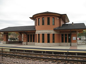
Fare zone C Services Preceding station Metra Following station Union Pacific/Northwest toward OgilvieDee Road is one of two commuter railroad stations on Metra's Union Pacific/Northwest line in the City of Park Ridge, Illinois. It is officially located at 881 North Dee Road, and lies 14.6 miles (23.5 km) from the Ogilvie Transportation Center in Chicago.[2] In Metra's zone-based fare system, Dee Road is in zone C.
Dee Road Station was rebuilt in 2006 as a replacement for the former Dee Road Station on the opposite side of Dee Road, by the Chicago and North Western Railway in 1967.
The smaller parking area between Dee Road and Rowe Avenue, where the old station used to be was recommended by Metra, as well as parking at nearby Park Ridge Station. Bus connections are provided by Pace.
Pace Bus connections
- 209: Busse Highway.
- 226: Oakton Street.
- 240: Dee Road.
References
External links
- Metra - Dee Road Station
- Dee Road Station (Homer L. Chastain & Associates)
- Station from Dee Road from Google Maps Street View
- Station from Oakton Street from Google Maps Street View
Categories:- Metra stations
- Park Ridge, Illinois
- Stations along Chicago and North Western Railway lines
- Railway stations opened in 1967
- Illinois railway station stubs

Wikimedia Foundation. 2010.