- Wettern House
Infobox Modern building
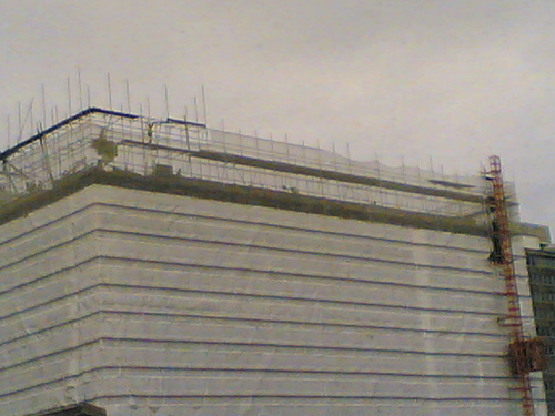
caption = Wettern House during demolison
name = Wettern House
location_town = East Croydon,London
location_country = ENG
coordinates =
architect =
client = Croydon Corporation
engineer =
construction_start_date= 1963
completion_date =
date_demolished = November 2005
cost =
structural_system =
style = |Wettern House was a former high rise building next to
East Croydon station inCroydon . Originally built in 1963, two years before theCounty Borough of Croydon disbanded into theLondon Borough of Croydon , it was demolished in November 2005 to make way forRuskin Square andCroydon Gateway . Before demolition, the building had 12 floors and a structural height of 38 m (124 ft). It's demolition was part of theCroydon Vision 2020 regeneration planning for a new generation of buildings.Progress of Gateway site
Throughout September to November 2005, Wettern House was the last office block located on the site to be slowly demolished under a protective wrapper to protect the rail infrastructure and surrounding buildings.
Between February and April 2006, the site was cleared of all occupiers (car parks and car rental, etc.) with the exception of the
Warehouse Theatre , with new hoardings now marking the boundaries of the main site. Stanhope Schroders now own large parcels of land to the north of the main site as well as office blocks in Croydon's central business district.July and August 2007 saw the company [http://www.mace.co.uk/ Mace] appointed as site managers by Stanhope. Further clearance works (enabling works) are now underway. Final designs of all buildings are being worked up by Foster + partners prior to foundations being dug this Autumn.
During September 2007, a new branding for the development took shape and all hoardings were brought up to standard ready for the commencement of works. Meanwhile, Croydon Council was under significant pressure to agree the final 'technical' planning conditions (such as the lighting scheme, drainage etc) to enable the Stanhope Scheme to commence its construction phase. On
12 September 2007 , Stanhope announced that the scheme would be renamed Ruskin Square.In October 2007, Croydon council continued to sit on the release of the final planning obligations on the Ruskin Square development. It is not known if the delay was connected to the public inquiry or the Arrowcroft issue.
On
June 2 2006 , Stanhope and Schroders were granted formal planning permission for their proposed Gateway scheme. MsRuth Kelly ,Secretary of State for Communities and Local Government endorsed the report of the local planning inspector and granted permission. The planning inspector Keith Durrant said of the scheme:See also
*
Croydon Tower
*Croydon Gateway External links
* [http://www.emporis.com/en/wm/bu/?id=wetternhouse-london-unitedkingdom Wettern House at Emporis]
Wikimedia Foundation. 2010.