- Pchery
Geobox | Settlement
name = Pchery
other_name =
other_name1 =
category = Village
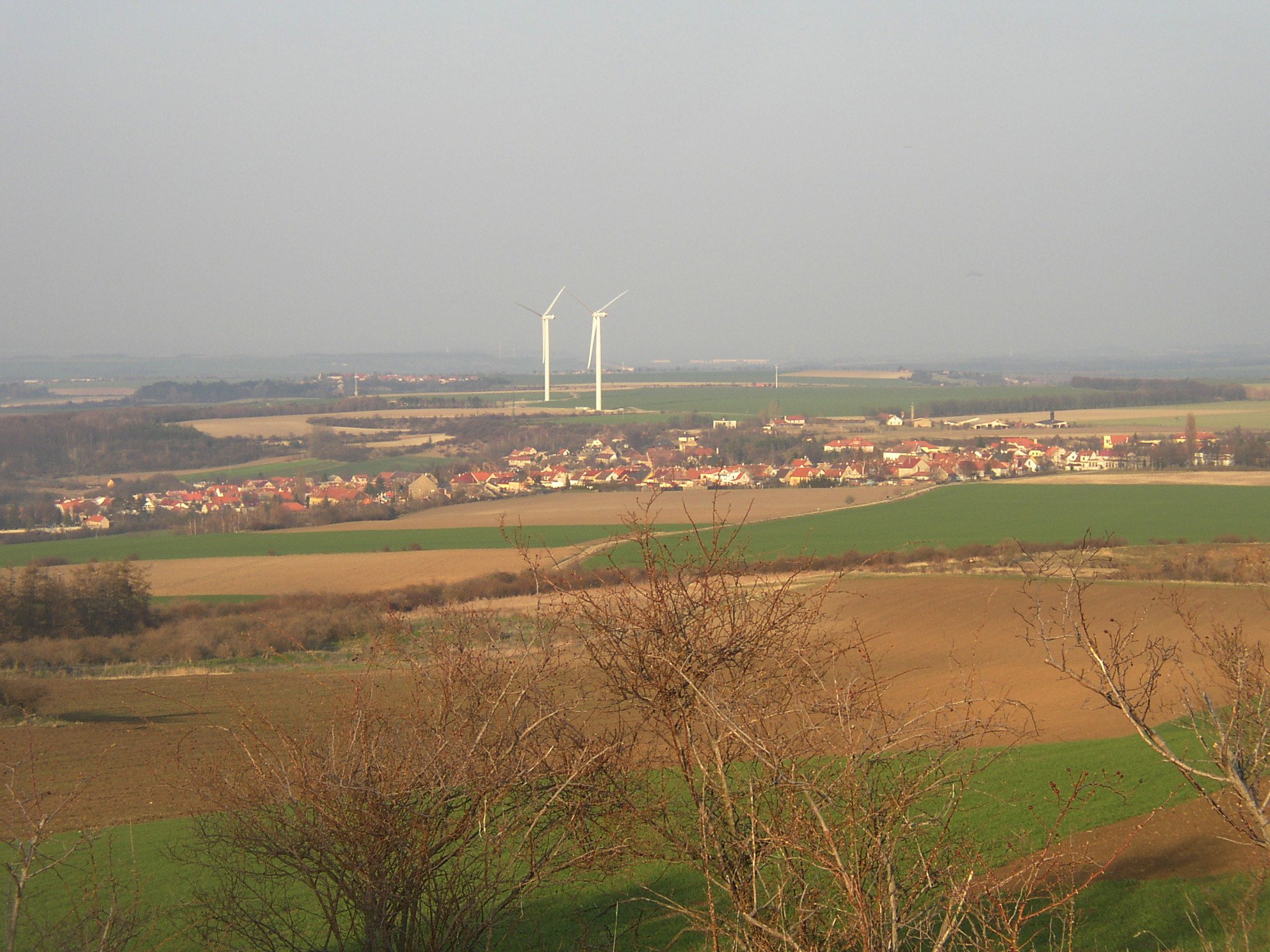
image_caption = Pchery from summit of theVinařická hora hill
symbol = Pchery CZ CoA.jpg
etymology =
official_name =
motto =
nickname =
country = Czech Republic
country_
state =
region = Central Bohemian
region_type = Region
district = Kladno
district_type = District
commune = Kladno
municipality =
part =
river =
location =
elevation = 324
lat_d = 50
lat_m = 11
lat_s = 29
lat_NS = N
long_d = 14
long_m = 06
long_s = 51
long_EW = E
highest =
highest_elevation = 364
highest_lat_d =
highest_long_d =
lowest =
lowest_elevation = 247
lowest_lat_d =
lowest_long_d =
area = 6.74
area_round = 2
population = 1806
population_date = 2006
population_density = auto
established = 1127
established_type = First mention
mayor = František Dufek
timezone = CET
utc_offset = +1
timezone_DST = CEST
utc_offset_DST = +2
postal_code = 273 08
area_code =
code =
free =

map_background = Czechia - background map.png
map_locator = Czechia
commons = Pchery
statistics = [http://www.statnisprava.cz/ebe/ciselniky.nsf/i/532720 statnisprava.cz]
website = [http://www.obecpchery.cz/ www.obecpchery.cz]
footnotes =Pchery (pronounced|ˈpxɛrɪ) is a village in
Central Bohemian Region of theCzech Republic . It is located about 5 km north of Kladno and has a population of 1,806 (2006). The village occupies an upper part of right slope of broad valley of theKnovízský potok stream, just on northwestern edge of large elevated plateau called "Rovina" ("The Plains" ). Pchery proper consist of two formerly distinct villages of Pchery and Humny, which today form one built-up area. Village of Theodor, once a late 19th century miners' settlement in vicinity of former colliery of the same name, located about 1.5 km to the southeast, also forms an administrative part of Pchery.The first mention of the village dates back to 12th century. In a document from about 1127–1128 it was stated to be in property of the
Saint George Cloister ofPrague Castle .Parish church of St. Stephen in Pchery was first attested intithe registry in 1352. It was enlarged from one to threenave s in Baroque style in 1706. Above the church there stands abelfry built around half of 18th century.A wind power plant, the most powerful in the Czech Republic as of 2008, has been operating on a field about 1 km northest of Pchery since April 1, 2008. It consists of two towers of 88 m in height, each equipped with a 3MW
wind turbine supplied by Finnish manufacturerWinWinD .Oldřich Duras , Czech chess Grandmaster was born in local part of Humny in 1882.Gallery
Pchery
Theodor
Wind power plant
External links
* [http://www.obecpchery.cz/ Municipal website] cs icon
* [http://www.vtepchery.cz/ Wind power plant Pchery] cs icon__NOTOC__


Wikimedia Foundation. 2010.