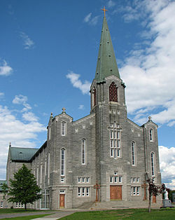
- Montmagny, Quebec
-
Ville de Montmagny — City — Saint Thomas Church Country Canada Province Quebec MRC Montmagny Established 1966 Government - Type City - Mayor Jean-Guy Desrosiers - Governing Body - MP - MNA Area - Total 126.07 km2 (48.7 sq mi) Population (2006)[1] - Total 11,353 Time zone EST (UTC-5) - Summer (DST) EDT (UTC-4) Montmagny is a city in the Montmagny Regional County Municipality within the Chaudière-Appalaches region of Quebec. It is the county seat. The city is located on the south shore of the Saint Lawrence River east of Quebec City and was founded more than 350 years ago. It is Canada's Snow Goose Capital.
Festivals include the International Accordion Festival in September and the Festival of the Snow Geese in October.
The city was named after Charles Jacques Huault de Montmagny, the first governor of New France. Samuel de Champlain was commander in chief.
According to the Canada 2006 Census:
- Population: 11,353
- % Change (2001–2006): -2.6
- Dwellings: 5,404
- Area (km²): 126.07 km²
- Density (persons per km²): 90.1
Contents
Geographical Location
Montmagny is north west of Notre-Dame mountains, (section of Chaudière-Appalaches), on the Saint-Lawrence river. The city is separated by the South River, where a smaller river flows named Bras-Saint-Nicolas. These two rivers cause the flow to become falls, which subsequently flow into the Saint-Lawrence.
Montmagny is the seat of the judicial district of Montmagny.[1]
Economy
The industrial sector is the backbone of the economy. However, the city lost many jobs when Whirlpool closed its activities on May 13, 2004, incurring the lost of 600 jobs. The city has rebounded from that period.
Famous personalities
- Thrulane James Rose, Prized cow Holstein from the farm of Pierre Boulet, World Dairy Expo 2008 Championships.
Climate
Climate data for Montmagny Month Jan Feb Mar Apr May Jun Jul Aug Sep Oct Nov Dec Year Record high °C (°F) 14
(57)13
(55)19
(66)30
(86)32.2
(90.0)35
(95)36
(97)33.3
(91.9)30.5
(86.9)24.5
(76.1)22
(72)21
(70)36
(97)Average high °C (°F) −7.2
(19.0)−5.2
(22.6)0.4
(32.7)7.5
(45.5)16.2
(61.2)21.9
(71.4)24.8
(76.6)23.4
(74.1)17.7
(63.9)10.7
(51.3)3.3
(37.9)−3.8
(25.2)9.1 Daily mean °C (°F) −11.9
(10.6)−10
(14)−4.3
(24.3)3
(37)10.7
(51.3)16.3
(61.3)19.2
(66.6)18
(64)12.9
(55.2)6.5
(43.7)−0.2
(31.6)−8
(18)4.4 Average low °C (°F) −16.5
(2.3)−14.8
(5.4)−8.9
(16.0)−1.5
(29.3)5.1
(41.2)10.7
(51.3)13.6
(56.5)12.6
(54.7)8
(46)2.2
(36.0)−3.7
(25.3)−12.1
(10.2)−0.5 Record low °C (°F) −37
(−35)−31.7
(−25.1)−32
(−26)−19
(−2)−6.1
(21.0)−2.5
(27.5)2
(36)1
(34)−4.5
(23.9)−7.8
(18.0)−20
(−4)−32
(−26)−37
(−35)Precipitation mm (inches) 85.1
(3.35)61.7
(2.429)73.3
(2.886)81.1
(3.193)101.5
(3.996)105.2
(4.142)129.2
(5.087)119.2
(4.693)115.6
(4.551)103.6
(4.079)90.4
(3.559)87.6
(3.449)1,153.5
(45.413)Source: Environment Canada[2] References
- ^ Territorial Division Act. Revised Statutes of Quebec D-11.
- ^ Environment Canada Canadian Climate Normals 1971–2000, accessed 29 April 2010
External links
 Administrative divisions of Chaudière-Appalaches (Region 12)
Regional county municipalities
and equivalent territoriesL'Islet · Montmagny · Bellechasse · Lévis · La Nouvelle-Beauce · Robert-Cliche · Les Etchemins · Beauce-Sartigan · Les Appalaches · Lotbinière
Municipalities Saint-Pamphile · Montmagny · Lévis · Sainte-Marie · Saint-Lambert-de-Lauzon · Beauceville · Saint-Joseph-de-Beauce · Saint-Georges · Disraeli (V) · Thetford Mines
Administrative divisions of Quebec Coordinates: 46°58′N 70°33′W / 46.967°N 70.55°W
Categories:- Incorporated places in Chaudière-Appalaches
- Cities and towns in Quebec
- Chaudière-Appalaches geography stubs
Wikimedia Foundation. 2010.


