- Texas State Highway Loop 13
Infobox TX State Highway
type=Loop
route=13
shields=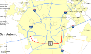
length_mi=21.684
length_ref=TxDOT|SL|13|accessdate=2008-02-22]
length_round=3
formed=Before 1939
dir1=CCW
dir2=CW
from=jct|state=TX|US|90
junction=jct|state=TX|I|35
jct|state=TX|I|37|US|281
jct|state=TX|US|87
jct|state=TX|I|10|US|90
to=jct|state=TX|I|410
previous_type=Loop
previous_route=12
next_type=Loop
next_route=14Loop 13 is a convert|21.684|mi|km|3|sing=on partial
loop route around the city of San Antonio in theU.S. state ofTexas . Prior to Interstate 410 (I-410), Loop 13 served as the primary loop for the city. Loop 13 follows Military Drive from U.S. Highway 90 (US 90) through the south side of the city. It then follows W.W. White road after it turns to the north through the east side of San Antonio before ending at I-410. The road is still a major arterial for the city, providing access toLackland Air Force Base ,Kelly USA , andBrooks City-Base .History
Loop 13 originally ran from the rail overpass near
Kelly Field east through the south side of San Antonio, then turning towards the north to US 81 on the northeast side of the city in 1939. Loop 13 Prior to I-410, Loop 13 served as the primary loop for the city. In 1941, the loop had its western end extended northward to a junction with US 90 on the west side of the city. Another extension on its eastern end convert|2.7|mi|km, brought the loop back to the west to Military Road. In 1949, it was extended further from Military Road to US 281. The loop saw its final extension in 1952, an extension that completed the loop around the city. In the 1960s, the loop began to see its demise at the onset of theInterstate Highway System as it began to be replaced by I-410. In 1960, the section from US 90 on the west side of the city north to I-10 was transferred to I-410 and the section from I-10 eastward to US 81 along the city's northside was renumbered as Loop 410 to keep the numbering of I-410 intact despite this section not meeting Interstate standards at the time. In 1966, the section from I-35, formerly US 81, south to Seale Road became I-410, with the section from Seale Road south to US 90 was removed from the state highway system. But in 1978, this segment would later be readded to the highway bringing Loop 13 to its current alignment.Route description
Loop 13 begins on the west side of San Antonio at US 90 north of
Lackland Air Force Base . The loop heads south along Military Drive, between two sections of Lackland, before turning towards the southeast. It turns towards the east at the intersection withFarm to Market Road 2536 (FM 2536) at Old Pearsall Road, just before a crossing overLeon Creek and aUnion Pacific rail yard . An intersection with Loop 353 (New Laredo Highway), which was the routing of US 81 when it still passed through town, provides access toKelly USA . Loop 13 passes under I-35 as it heads east through the south side of the city. It intersects Spur 536 at Roosevelt Avenue, which provides access toStinson Airport and Mission San Jose. The loop crosses over theSan Antonio River just before a junction with Spur 122 at Presa Street. As it nears I-37, it passes nearbyBrooks City-Base . At Spur 117, Loop 13 turns towards the north and begins following W.W. White Road. It intersects US 87 at Rigsby Avenue as it passes through the east side of San Antonio. It intersects FM 1346 at Houston Street and I-10 before ending at I-410 east ofFort Sam Houston .cite map|publisher=Google Maps |url=http://maps.google.com/maps?f=d&hl=en&geocode=15155009709023561588,29.401260,-98.627660%3B5168128330147143174,29.362045,-98.574631%3B865363212872899702,29.351880,-98.457520%3B11279689809441750572,29.370490,-98.404470%3B11395726621551799193,29.445993,-98.404162&saddr=TX-13-LOOP+S+%4029.401260,+-98.627660&daddr=SW+Military+Dr+%4029.362045,+-98.574631+to:SE+Military+Dr+%4029.351880,+-98.457520+to:S+WW+White+Rd+%4029.370490,+-98.404470+to:29.447222,-98.405056&mra=dme&mrcr=0&mrsp=4&sz=13&via=1,2,3&sll=29.448866,-98.386173&sspn=0.098807,0.159645&ie=UTF8&ll=29.418965,-98.500671&spn=0.197673,0.31929&z=12|title=Overview map of Loop 13|accessdate=2008-02-22]Junction list
References

Wikimedia Foundation. 2010.