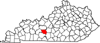
Chalybeate Springs, Kentucky
Look at other dictionaries:
Russell Springs, Kentucky — Infobox Settlement official name = Russell Springs, Kentucky settlement type = City nickname = motto = imagesize = image caption = image mapsize = 250px map caption = Location of Russell Springs, Kentucky mapsize1 = map caption1 = subdivision… … Wikipedia
Chalybeate — The Calybeate Spring Tunbridge Wells Chalybeate waters, also known as ferruginous waters, are mineral spring waters containing salts of iron. Contents 1 … Wikipedia
Edmonson County, Kentucky — Infobox U.S. County county = Edmonson County state = Kentucky founded year = 1826 founded date = seat wl = Brownsville area total sq mi = 308 area total km2 = 798 area land sq mi = 303 area land km2 = 784 area water sq mi = 5 area water km2 = 14… … Wikipedia
National Register of Historic Places listings in Edmonson County, Kentucky — Location of Edmonson County in Kentucky This is a list of the National Register of Historic Places listings in Edmonson County, Kentucky. It is intended to be a complete list of the properties and districts on the National Register of Historic… … Wikipedia
Comté d'Edmonson (Kentucky) — Comté d Edmonson Comté d Edmonson Administration … Wikipédia en Français
Marcellus Formation — Stratigraphic range: Middle Devonian … Wikipedia
National Register of Historic Places listings in Alleghany County, Virginia — Map of all coordinates from Google Map of all coordinates from Bing … Wikipedia
Área metropolitana de Bowling Green — Bowling Green, KY MSA Área metropolitana de los Estados Unidos … Wikipedia Español
Comté d'Edmonson — 37° 13′ N 86° 15′ W / 37.21, 86.25 … Wikipédia en Français
Comté de Edmonson — Comté d Edmonson Comté d Edmonson Administration … Wikipédia en Français