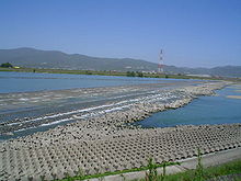
Yoshino River

Yoshino River
Yoshino Daiju Dam

The Yoshino River (吉野川 Yoshino-gawa) is a river on the island of Shikoku, Japan. It is 194 km long and has a watershed of 3,750 km². It is the second longest river in Shikoku (slightly shorter than the Shimanto), and is the only river whose watershed spreads over the four prefectures of the island.

It is regarded as one of the three greatest rivers of Japan along with the Tone and the Chikugo, and is nicknamed Shikoku Saburō (四国三郎; Saburō is a popular given name for a third son).

The Yoshino rises from Mount Kamegamori (瓶ケ森) in Ino, Kochi Prefecture and flows to the east. In Otoyo it turns to the north and crosses the Shikoku Mountains. The gorge, named Ōboke Koboke, is a famous tourist attraction of Shikoku. In Ikeda, Tokushima Prefecture it turns to the east again and pours into the sea at the north of Tokushima city. Its major tributaries include Ananai, Iya, Dōzan, Sadamitsu, and Anabuki.

The river has some "submerged bridges" (潜水橋 Sensuikyō), equivalents of Chinkabashi of the Shimanto, which lack parapets in order not to be washed away by floods. Reconstruction of the Yoshino Daiju Dam (吉野川第十堰 Yoshino-gawa Daijūzeki) near its mouth provoked much controversy among environmentalists.

External links

34°04′43″N 134°36′03″E / 34.078499°N 134.600722°E / 34.078499; 134.600722Coordinates: 34°04′43″N 134°36′03″E / 34.078499°N 134.600722°E / 34.078499; 134.600722 (mouth)


Wikimedia Foundation. 2010.

Игры ⚽ Нужно сделать НИР?

Look at other dictionaries:

  • Yoshino, Nara — Infobox City Japan Name= Yoshino JapaneseName= 吉野町 Map Region= Kansai Prefecture= Nara Prefecture District= Yoshino District Area km2= 95.96 PopDate= September 1, 2007 Population= 9397 Density km2= 97.93 Coords= coord|34|24|N|135|51|E|region:JP… …   Wikipedia

  • Kinokawa River — The nihongo|Kinokawa or redundantly Kinokawa River|紀ノ川 or 紀の川|Kinokawa is a river in Nara and Wakayama Prefecture in Japan. It is called nihongo|Yoshino River|吉野川|Yoshinogawa in Nara. It is 136 km long and has a watershed of 1,660 km².The river… …   Wikipedia

  • Dōzan River — 銅山川 Origin Mount Kanmuri Mouth Yoshino River Basin countries Japan …   Wikipedia

  • Suketo River — Infobox River river name=Suketo River image size = 250px caption = The Suketo River, one of the rivers running through the center of Tokushima City. origin=Runoff from the Shinmachi River river mouth=Shinmachi River river location=Tokushima City… …   Wikipedia

  • Tone River — The nihongo|Tone River|利根川|Tonegawa is a river in the Kantō region of Japan. It is 322 km in length (the second longest in Japan after the Shinano) and has a drainage area of 16,840 km² (largest in Japan). It is nicknamed nihongo|Bando… …   Wikipedia

  • Battle of the Yalu River (1894) — Infobox Military Conflict conflict=Battle of Yalu River (1894) caption=The French built Matsushima , flagship of the Imperial Japanese Navy, during the battle of the Yalu River partof=the First Sino Japanese War date=September 17, 1894… …   Wikipedia

  • Ohashi Dam — Location Kōchi Prefecture, Japan Ohashi Dam (Japanese: 大橋ダム) is a dam built on the Yoshino River in Agawa District, Kōchi Prefectur …   Wikipedia

  • Tokushima Prefecture — Infobox Prefecture Japan Name = Tokushima JapaneseName = 徳島県 Rōmaji = Tokushima ken Symbol = PrefSymbol Tokushima.png Capital = Tokushima (city) Region = Shikoku Island = Shikoku TotalArea = 4,144.95 AreaRank = 36th PCWater = 1.5 PopDate =… …   Wikipedia

  • Mima, Tokushima — Mima 美馬市   City   Location of Mima in Tokushima …   Wikipedia

  • Motoyama, Kōchi — For the area in Chikusa ku, Nagoya, see Motoyama. Motoyama 本山町   Town   …   Wikipedia

Share the article and excerpts

Direct link
Do a right-click on the link above
and select “Copy Link”