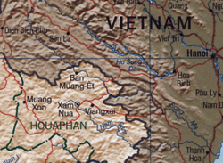
Nam Sam River

Nam Sam River
Nam Sam River on map

Chu River (name in Vietnam, Vietnamese: Sông Chu) or Nam Sam River (name in Laos) is the largest tributary of Ma River. It originates from Houa peak at 2062 m near Sam Neua town, Houaphan Province in Eastern Laos and travels eastern to meander through Nghe An and Thanh Hoa Provinces of Vietnam. It joins Ma River on the left in Thieu Hoa.

The river is 325 km long (165 km in Laos and 160 km in Vietnam) with a drainage area of about 7,580 km² (4,570 km² in Laos and 3,010 km² in Vietnam).


Wikimedia Foundation. 2010.

Игры ⚽ Поможем написать реферат

Look at other dictionaries:

  • Nam Phong District — Nam Phong น้ำพอง   Amphoe   Amphoe location in Khon Kaen Province …   Wikipedia

  • River trekking — or river tracing is a form of hiking or outdoor adventure activity, particularly popular in Hong Kong and Taiwan, and, in some ways, similar to canyoning or canyoneering. River trekking is a combination of trekking and climbing and sometimes… …   Wikipedia

  • Sam Phran — สามพราน Provinz: Nakhon Pathom Fläche: 249,3 km² Einwohner: 171.562 (2007) Bev.dichte: 688 E./km² PLZ: 73110 …   Deutsch Wikipedia

  • Chu River — Coordinates: 44°59′N 67°43′E / 44.983°N 67.717°E / 44.983; 67.717 …   Wikipedia

  • Ma River — Mã River in Thanh Hoa city, Vietnam. Mã River. The Ma River (Vietname …   Wikipedia

  • Nam Yuen District — Nam Yuen น้ำยืน   Amphoe   Amphoe location in Ubon Ratchathani Province …   Wikipedia

  • Nam Nao National Park — is located in Nam Nao District, Phetchabun Province in northern Thailand. It is situated 50 kilometres (31 mi) west of Amphoe Lom Sak. The park is a large forest still in its original state. It is filled with pineries, grasslands and virgin… …   Wikipedia

  • Nam Koong Won — This is a Korean name; the family name is Nam Koong. Nam Koong Won Born August 1, 1934(1934 08 01) Seoul, South Korea Occupation Actor Years active 1959–present …   Wikipedia

  • River Systems of Thailand — The two principal river systems of Thailand are the Chao Phraya and the Mekong. Together, these rivers support the irrigation for Thailand s agricultural economy. In addition to these two large systems, there are a number of other river systems… …   Wikipedia

  • Wang Thong River — Infobox River river name = Wang Thong River caption = Wang Thong River in Wang Thong origin = Phetchabun Mountains in the Khao Kho District, Thailand mouth = Nan River at coord|16|31|06|N|100|19|36|E|type:landmark region:TH basin countries =… …   Wikipedia

Share the article and excerpts

Direct link
Do a right-click on the link above
and select “Copy Link”