Mbinda

Mbinda
Mbinda
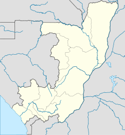
Mbinda is located in Republic of the Congo
Mbinda
Location in the Republic of the Congo
Coordinates: 2°06′S 12°52′E / 2.1°S 12.867°E / -2.1; 12.867
Country Flag of the Republic of the Congo.svg Republic of the Congo
Region Niari Region
District Mayoko District

Mbinda is a town in the Republic of Congo, lying on the border with Gabon. It is a transport hub and lies at the end of a railway line to Brazzaville.

The town prospered as the southern end of the 75 km COMILOG Cableway from Moanda in Gabon, exporting manganese via Brazzaville, but this closed in 1986 when the Trans-Gabon Railway was completed. However, a rail link from Franceville to Brazzaville, probably via the town, is regularly proposed.

See also

References

Coordinates: 2°06′S 12°52′E / 2.1°S 12.867°E / -2.1; 12.867


Wikimedia Foundation. 2010.

Игры ⚽ Поможем написать курсовую

Look at other dictionaries:

  • Mossendjo — Mossendjo …   Wikipedia

  • COMILOG Cableway — The COMILOG Cableway was one of the longest cableways in the world, until its closure in 1986.[1] The ropeway conveyor ran for 76 km from Moanda in the Haut Ogooué Province of south eastern Gabon to Mbinda in the Republic of Congo. In 1954, the… …   Wikipedia

  • Transport in the Republic of the Congo — Railways = total: 795 km (includes 285 km private track) Congo Ocean Railway connects Brazzaville and Pointe Noire. narrow gauge: 795 km 1.067 m gauge (1995 est.) Railway links to adjacent countries * Democratic Republic of the Congo (Cabinda) no …   Wikipedia

  • Moanda — This article is about the town in Gabon. For the village in the Democratic Republic of Congo, see Muanda. Not to be confused with Moande. Moanda …   Wikipedia

  • Railway stations in Congo — include: Maps * [http://www.un.org/Depts/Cartographic/map/profile/congo.pdf UN Map] * [http://www.reliefweb.int/rw/RWB.NSF/db900LargeMaps/SKAR 64GDLY?OpenDocument cc=cog rc=1] * [http://www.reliefweb.int/rw/fullMaps… …   Wikipedia

  • Congo–Ocean Railway — The Congo–Ocean Railway (COR; French: Chemin de fer Congo Océan, CFCO) links the Atlantic port of Pointe Noire (now in the Republic of Congo) with Brazzaville, a distance of 502 kilometres. It bypasses the rapids on the lower Congo River; from… …   Wikipedia

  • COMILOG-Materialseilbahn — Die COMILOG Materialseilbahn war eine der längsten Seilbahnen der Welt. Sie transportierte von 1957 bis 1986 Manganerz von Moanda in der Provinz Haut Ogooué im Osten von Gabun über 76 Kilometer nach Mbinda in der Republik Kongo. Die Compagnie… …   Deutsch Wikipedia

  • Chemin de fer Congo-Océan — Die Kongo Ozean Bahn (CFCO, von französisch: Chemin de fer Congo Océan) ist eine 510 km lange Eisenbahn in der Republik Kongo, welche den Hafen von Pointe Noire am Atlantischen Ozean mit Brazzaville am Kongo verbindet …   Deutsch Wikipedia

  • Empire Kongo — Pour les articles homonymes, voir Kongo. L’empire Kongo était un empire de l Afrique du sud ouest, situé dans des territoires du nord de l Angola, de Cabinda, de la République du Congo, l extrémité occidentale de la République démocratique du… …   Wikipédia en Français

  • Kongo (royaume) — Empire Kongo Pour les articles homonymes, voir Kongo. L’empire Kongo était un empire de l Afrique du sud ouest, situé dans des territoires du nord de l Angola, de Cabinda, de la République du Congo, l extrémité occidentale de la République… …   Wikipédia en Français

Share the article and excerpts

Direct link
Do a right-click on the link above
and select “Copy Link”