- Lang, Saskatchewan
Infobox Settlement
official_name = Village of Lang
other_name =
native_name =
nickname =
settlement_type =
motto =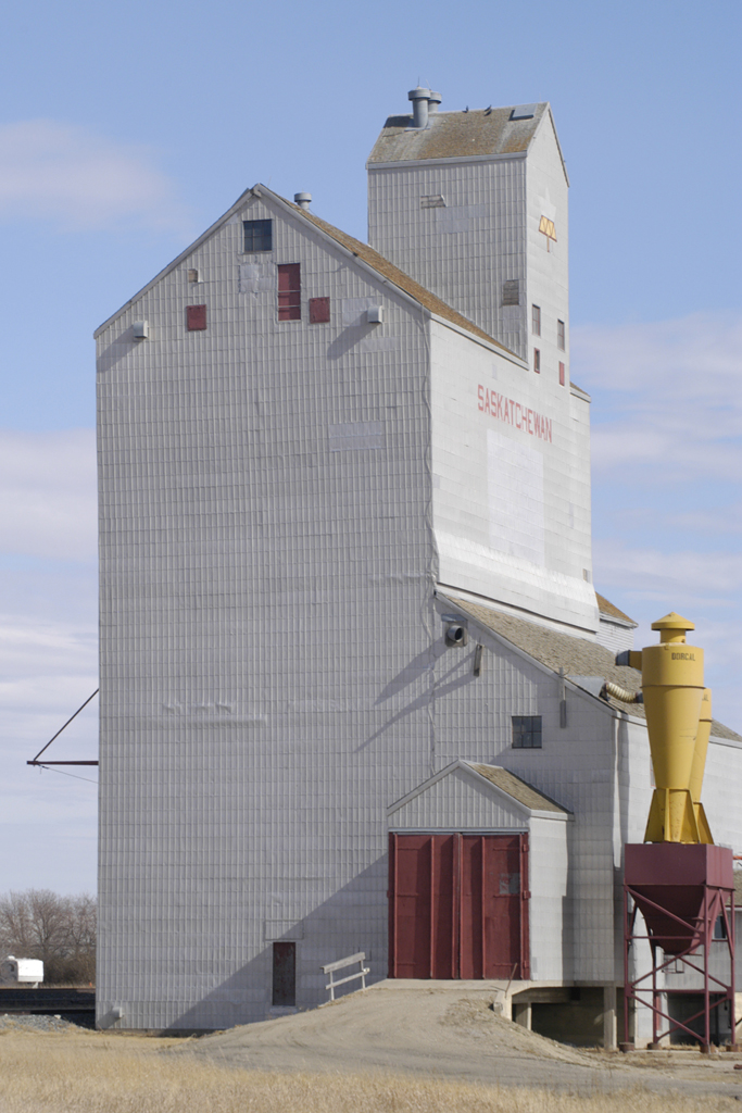
imagesize = 270px
image_caption = Grain elevator in Lang
flag_size =
image_
seal_size =
image_shield =
shield_size =
city_logo =
citylogo_size =
mapsize =
map_caption =
mapsize1 =
map_caption1 =
image_dot_
dot_mapsize =
dot_map_caption =
dot_x = |dot_y =
pushpin_
pushpin_label_position = none
pushpin_map_caption = Lang inSaskatchewan
pushpin_mapsize = 180
subdivision_type =Country
subdivision_name = CAN
subdivision_type1 = Province
subdivision_name1 = SK
subdivision_type2 = Region
subdivision_name2 =Saskatchewan
subdivision_type3 = Census division
subdivision_name3 = 2
subdivision_type4 = Rural Municipality
subdivision_name4 = Scott
government_footnotes =
government_type =
leader_title =Mayor
leader_name = Al Broderick
leader_title1 =Administrator
leader_name1 = Audette Ernest
leader_title2 = Governing body
leader_name2 = Lang Village Council
leader_title3 =
leader_name3 =
leader_title4 =
leader_name4 =
established_title = Post office Founded
established_date =N/A
established_title2 = Incorporated (Village)
established_date2 =N/A
established_title3 = Incorporated (Town)
established_date3 =N/A
area_magnitude =
unit_pref =
area_footnotes =
area_total_km2 = 0.64
area_land_km2 =
area_water_km2 =
area_total_sq_mi =
area_land_sq_mi =
area_water_sq_mi =
area_water_percent =
area_urban_km2 =
area_urban_sq_mi =
area_metro_km2 =
area_metro_sq_mi =
population_as_of = 2001
population_footnotes =
population_note =
population_total = 189
population_density_km2 = 293.8
population_density_sq_mi =
population_metro =
population_density_metro_km2 =
population_density_metro_sq_mi =
population_urban =
population_density_urban_km2 =
population_density_urban_sq_mi =
population_blank1_title = National Population Rank
population_blank1 =
population_density_blank1_km2 = |population_density_blank1_sq_mi =
timezone = CST
utc_offset =
timezone_DST =
utc_offset_DST =
latd=49.91853
longd=-104.37282
elevation_footnotes =
elevation_m =
elevation_ft =
postal_code_type =Postal code
postal_code = S0G 2W0
area_code = 306
blank_name = Highways
blank_info = Highway 39
blank1_name = Waterways
blank1_info =
website = http://www.langsk.com/
|footnotes = [Citation
last =National Archives
first =Archivia Net
author-link =
last2 =
first2 =
author2-link =
title =Post Offices and Postmasters
date =
year =
url =http://www.collectionscanada.ca/archivianet/post-offices/001001-100.01-e.php
accessdate = ] [Citation
last =Government of Saskatchewan
first =MRD Home
author-link =
last2 =
first2 =
author2-link =
title = Municipal Directory System
date =
year =
url =http://www.municipal.gov.sk.ca/index.html
accessdate = ] [Citation
last =Canadian Textiles Institute.
first =
author-link =
last2 =
first2 =
author2-link =
title =CTI Determine your provincial constituency
date =
year =2005
url =http://www.textiles.ca/eng/nonAuthProg/redirect.cfm?path=IssPolContacts§ionID=7601.cfm
accessdate = ] [Citation
last =Commissioner of Canada Elections
first =Chief Electoral Officer of Canada
author-link =
last2 =
first2 =
author2-link =
title =Elections Canada On-line | Home
date =
year =2005
url =http://www.elections.ca/home.asp
accessdate = ]Lang is a
village in the Canadianprovince ofSaskatchewan .Demographics
Canada_CP_2001|pop=189|popDelta=0.0
landArea=0.64|popDensity=293.8|medianAge=44.1|medianAgeM=44.3|medianAgeF=44.0
privateDwell=89|medianHHIncome=NAEducation
Students from Lang attend school in Milestone, of the [http://www.saskschools.ca/~pvsdmile/ Prairie Valley School Division] .
See also
*
List of communities in Saskatchewan
*Villages of Saskatchewan Canadian City Geographic Location (8-way)
Northwest =
External links
* [http://www.langsk.com/ Village of Lang]
* [http://www.becquet.com/director/maps/index.htm Saskatchewan City & Town Maps]
* [http://www.rootsweb.com/~cansk/school/ Saskatchewan Gen Web - One Room School Project ]
* [http://www.collectionscanada.ca/archivianet/post-offices/001001-100.01-e.php Post Offices and Postmasters - ArchiviaNet - Library and Archives Canada]
* [http://www.rootsweb.com/~cansk Saskatchewan Gen Web Region]
* [http://www.rootsweb.com/~canmaps/index.html Online Historical Map Digitization Project]
* [http://geonames.nrcan.gc.ca/search/search_e.php GeoNames Query ]
* [http://www12.statcan.ca/english/census06/data/profiles/community/Index.cfm?Lang=E 2006 Community Profiles]Footnotes


Wikimedia Foundation. 2010.