- Negro Bill Canyon
-
Coordinates: 38°36′26″N 109°31′52″W / 38.60722°N 109.53111°W
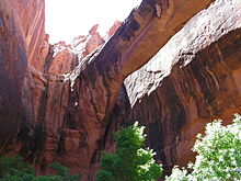
Negro Bill Canyon (formerly called Nigger Bill Canyon[1]) is a canyon in southeast Utah. It is part of the Colorado River watershed. Its stream flows directly into the main channel of the Colorado River within Moab Canyon.
A trailhead which gives hiking access into the canyon is located directly adjacent to Utah State Route 128. The trailhead is located about 3 miles (5 km) east of the junction of Route 128 and US Route 191. The Morning Glory Arch/Natural Bridge is located about 2.5 miles (4 km) from the trailhead and has a girth of 243 feet (74m).
The canyon was named after William Granstaff, a mixed-race cowboy, who prospected and ran cattle in the desert canyon in the late 1870s with a Canadian trapper named "Frenchie". They took joint possession of the abandoned Elk Mountain Mission fort near Moab after 1877, and each controlled part of the Spanish Valley. Granstaff fled the area in 1881 after being charged with bootlegging whiskey to the Indians.[1]
In 1979 the canyon was the scene of a dispute over public vehicle access, sometimes called the Sagebrush Rebellion.
See also
References
- ^ a b Van Cott, John W. (1990). Utah Place Names. Salt Lake City, Utah: University of Utah Press. pp. 271–272. ISBN 0-87480-345-4.
External links
- Negro Bill Canyon Trail - Bureau of Land Management
- Excerpts from Utah's Favorite Hiking Trails
Categories:- Canyons and gorges of Utah
- Landforms of Grand County, Utah
- Protected areas of Grand County, Utah
- Bureau of Land Management areas in Utah
- Utah geography stubs
Wikimedia Foundation. 2010.


