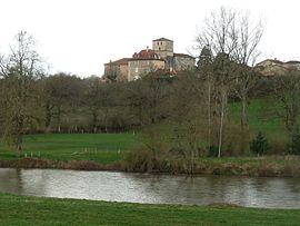
- Manot, Charente
-
Manot

 ManotLocation within Poitou-Charentes region
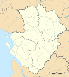 Manot
ManotAdministration Country France Region Poitou-Charentes Department Charente Arrondissement Confolens Canton Confolens-Nord Intercommunality Confolentais Mayor Jean-Luc Dedieu
(2008–2014)Statistics Elevation 132–231 m (433–758 ft)
(avg. 191 m/627 ft)Land area1 20.34 km2 (7.85 sq mi) Population2 594 (2008) - Density 29 /km2 (75 /sq mi) INSEE/Postal code 16205/ 16500 1 French Land Register data, which excludes lakes, ponds, glaciers > 1 km² (0.386 sq mi or 247 acres) and river estuaries. 2 Population without double counting: residents of multiple communes (e.g., students and military personnel) only counted once. Coordinates: 45°56′37″N 0°38′17″E / 45.9436111111°N 0.638055555556°E
Manot is a commune in the Charente department in southwestern France.
Population
Historical population of Manot, Charente 1793 1800 1806 1821 1831 1841 1846 1851 1856 1861 1048 1214 1079 1282 1298 1320 1340 1353 1345 1196 1866 1872 1876 1881 1886 1891 1896 1901 1906 1911 1164 1124 1240 1513 1269 1275 1212 1160 1161 1009 1921 1926 1931 1936 1946 1954 1962 1968 1975 1982 885 821 802 770 684 687 708 681 672 590 1990 1999 2008 584 577 594 See also
References
Categories:- Communes of Charente
- Charente geography stubs


Wikimedia Foundation. 2010.