- Monthermé
-
Monthermé

Administration Country France Region Champagne-Ardenne Department Ardennes Arrondissement Charleville-Mézières Canton Monthermé Intercommunality Meuse et Semoy Mayor Alain Bernard
(2008–2014)Statistics Elevation 156 m (512 ft) avg. Land area1 32.33 km2 (12.48 sq mi) Population2 2,498 (2008) - Density 77 /km2 (200 /sq mi) INSEE/Postal code 08302/ 08800 1 French Land Register data, which excludes lakes, ponds, glaciers > 1 km² (0.386 sq mi or 247 acres) and river estuaries. 2 Population without double counting: residents of multiple communes (e.g., students and military personnel) only counted once. Coordinates: 49°53′11″N 4°43′56″E / 49.8863888889°N 4.73222222222°E
Monthermé is a commune in the Ardennes department in northern France.
Contents
Geography
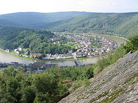
The river Semois (or Semoy) joins the river Meuse in Monthermé.
Population
Historical population of Monthermé 1793 1800 1806 1821 1831 1836 1841 1846 1851 1866 1520 1396 1425 1379 1660 1620 1976 2126 2299 2550 1872 1876 1881 1886 1891 1896 1901 1906 1911 1921 2599 3024 3383 3699 3870 4150 4272 4170 4456 3621 1926 1931 1936 1946 1954 1962 1968 1975 1982 1990 3842 3889 3705 3018 3468 3589 3212 3299 3103 2866 1999 2008 2791 2498 See also
References
Categories:- Communes of Ardennes
- Ardennes geography stubs
Wikimedia Foundation. 2010.


